Table of Contents
Sea of Okhotsk
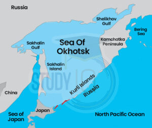
A small sea in the western Pacific Ocean, the Sea of Okhotsk is situated between the Japanese island of Hokkaido on the south, the Kamchatka Peninsula of Russia on the east, the Kuril Islands on the southeast, the island of Sakhalin on the west, and a section of the eastern Siberian coast on the west and north. It covers about 1,583,000 square kilometers and has an average depth of around 859 meters, with a maximum depth of 3372 meters.
Read More: Sea of Azov
Sea of Okhotsk Map
Here is a Map of the Sea of Okhotsk for a better understanding of the geographical region:
Read More: East China Sea
Sea of Okhotsk Location/Bordering Countries
The Sea of Okhotsk, or Okhotskoye More in Russian is a part of the northwest Pacific Ocean.
- The Sea of Okhotsk is bordered by Asia’s east coast on the west and north.
- To the east and southeast it is bordered by the Kuril Islands and Kamchatka Peninsula.
- The northern coast of Hokkaido in Japan is to the south.
- Sakhalin Island lies to the southwest.
- The sea is mostly surrounded by Russian land, except for a small area near Hokkaido.
- It covers about 1,583,000 square kilometers.
- The average depth of the sea is around 859 meters.
Read More: Mediterranean Sea
Sea of Okhotsk Physical Features
The major rivers that flow through the continent’s rocky shorelines include the
- Amur,
- Tugur,
- Uda,
- Okhota,
- Gizhiga, and
- Penzhina.
The beaches of Hokkaido and Sakhalin Island are lower. The southeast coast of Sakhalin has the Gulf of Aniva and Terpeniya. Only Ion Island is in open water; the other islands, like Shantar, Zavyalov, Spafaryev, Yam, and Tyuleny, are mostly near the shore. The Sea of Okhotsk was shaped by glaciation over the last two million years. The seafloor slopes from north to south, with a continental shelf that goes down to 650 feet (200 meters) along the northern and western coasts. About 70% of the sea gets deeper to the south and east, reaching around 5,000 feet (1,500 meters). The deepest spot is in the Kuril Basin, west of the Kuril Islands, at about 8,200 feet (2,500 meters). Most of the silt comes from the Amur River, along with volcanic activity and coastal erosion. The bottom of the Kuril Basin has clay-diatom silt, while closer to shore, there are fine sands, coarse sands, pebbles, and mussel shells.
Read More: South China Sea
Sea of Okhotsk Climate
The Sea of Okhotsk is the coldest sea in East Asia. In winter, its weather and temperatures are similar to those in the Arctic. The northeastern, northern, and western parts of the sea experience harsh winter conditions due to the Asian continent. From October to April, these areas are very cold, often covered in ice, and get very little precipitation. The climate here is mostly continental.
- The southern and southeastern areas have a milder marine climate due to the nearby Pacific Ocean.
- The coldest months are January and February, while the warmest are July and August.
- In February, the average temperature in the northeastern part is −4°F (−20°C), and in August, it is 54°F (12°C).
- In the northern and western areas, the February average is −11°F (−24°C) and 57°F (14°C) in August.
- The southern and southeastern areas have an average of 19°F (−7°C) in February and 64°F (18°C) in August.
- Yearly precipitation averages 400 mm in the north, 710 mm in the west, and about 41 inches (1,040 mm) in the south and southeast.
Read More: Atlantic Ocean
Sea of Okhotsk Significance
The sea is frequently used for transportation between the ports in eastern Russia. The two main ports on the continental coast are Okhotsk and Magadan located in Nagayeva Bay. Important cities include Korsakov on Sakhalin Island and Severo-Kurilsk and Yuzhno-Kurilsk on the Kuril Islands. In winter, ice floes make navigation difficult, while in summer, thick fog can be a problem. Additional dangers in the area include strong currents and submerged boulders. The area around the Sea of Okhotsk is crucial to the growth of eastern Russia’s economy.
Read about: Indian Ocean
Sea of Okhotsk Economic Significance
One of the waters in the world with the highest biological productivity is the Sea of Okhotsk. Marine life is favoured by river drainage, intense water mixing caused by channels and wind, and the upwelling of deep, nutrient-rich ocean waters. When the temperature is warm enough, an incredibly quick spread of life takes place. Algae and seaweed serve as the flora, while crayfish, sea mussels, crabs, sea urchins, polyps, and various fish serve as the fauna. Crab and shrimp, together with salmon, herring, pollack, flounder, cod, capelin, and smelts (or frostfish), are all crucial for commerce. Whales, seals, and sea lions are among the marine creatures that live in the sea.
In 1977, the Soviet Union declared a 200-mile exclusive economic zone, bringing almost the whole sea under its control. This led to favourable conditions for the exploitation of minerals and the growth of fisheries. Today, a sizable share of the catches in eastern Russia come from the sea. On the northern shelf of the sea, oil and gas resources have also been found.
Read More: Ocean Tides
Sea of Okhotsk Hydrology
The water of the Sea of Okhotsk is made up of continental drainage, Precipitation, and waters that enter the sea through the straits of the Kuril Islands and the La Perouse (Sya) Strait from the Pacific Ocean and the Sea of Japan (East Sea), respectively. The sea warms to a depth of 100 to 165 feet during the summer (30 to 50 metres). The surface water temperature increases to 46–54 °F (8–12 °C), while the salinity decreases to 32.5 ppt and below.
Deeper water contains a salinity of up to 34 parts per thousand and an average temperature of 29 to 30 °F (1.8 to 1°C). The cold-water layer’s thickness varies from a few feet in the sea’s southeast to 245 to 525 feet (75 to 160 metres) in its northwest.
Water in the Sea of Okhotsk generally flows in an anticlockwise direction. It gets water from the Sea of Japan, making the southwest part warmer. Warm water from the Pacific Ocean also flows in, so the eastern half of the sea is warmer than the western half.
The Kuril Islands are surrounded by currents that mostly move in a clockwise direction. In the northern part of the straits, currents flow into the sea, while in the southern part, they go back to the Pacific. The strongest tides are in Penzhin Bay, reaching 42.3 feet (12.9 meters), while the weakest tides are in southeast Sakhalin at 2.6 feet (0.8 meters).
Ice starts to cover the sea by the end of October, peaking in March. It reaches the shore in some coastal areas, but there is also floating ice in the open sea. The ice usually melts by June, except in the Sakhalin gulfs and around Shantar Island, where ice can sometimes be seen in July and even August.
Read More: Ocean Deposits
Sea of Okhotsk UPSC
The Okhotsk Circulation often referred to as the Oyashio Current or the Kurile Current, is a subarctic ocean current that loops anticlockwise in the western North Pacific Ocean and flows south. The Oyashio Current is a flow of cold water that originates in the Arctic Ocean and travels southward via the Bering Sea, the Bering Strait, and into the Pacific Ocean and the Sea of Okhotsk. You will learn about the Okhotsk Current from this article, which will help you with your UPSC Civil Service exam geography study.
Read More: Ocean Waves
 Sex Ratio in India 2026: Latest Trends, ...
 Civil Disobedience Movement (CDM): Cause...
 Role of Teachers in Educations, Student ...