Home   »   Brahmaputra River   »   Brahmaputra River

Brahmaputra River System, Tributaries, Map, Origin, Length

Brahmaputra River

One of the biggest rivers in the globe and a significant river in Asia is the Brahmaputra. It is an international river. While the majority of the rivers in India are regarded as female rivers, the Brahmaputra is seen as a masculine river. The river spans around 2900 km.

Yarlung Tsangpo River, a braided river that flows into the Brahmaputra, originates in southwest Tibet. Hindus regard the river as sacred because they believe it to be connected to many myths.

The Yarlung Tsangpo River, which flows into the Brahmaputra, has its source in the Angsi Glacier in southwest Tibet. It traverses the Himalayas and extends as Dihang into Arunachal Pradesh. As it approaches Assam, the Brahmaputra widens and grows stronger. The river spans around 2900 km. The river’s maximum depth is 120 metres, and its typical depth is 38 metres. The Himalayan snow melts, flooding the river causes. The river discharges water at a rate of 19,300 cubic metres per second on average. The river is vulnerable to avulsion and channel migration.

The Patkai-Bum hills, the northern slopes of the Meghalaya hills, the Assam plains, and the northern part of Bangladesh are all drained by the Brahmaputra, which also drains the Himalayas to the east of the Indo-Nepal border, the southern-central portion of the Tibetan plateau above the Ganges basin, the southeastern portion of the Tibetan plateau above the Ganges basin, the southeastern portion of Tibet. The Brahmaputra basin’s highest point is Kanchenjunga.

Brahmaputra River Length

The Brahmaputra River spans around 2900 km. The river’s highest depth is 120 metres, and its average depth is 38 metres.

Origin of Brahmaputra River

At a height of 5300 metres, the Kailash hills in the Himalayas are the river’s source. It then passes through Bangladesh and Assam before entering India through Arunachal Pradesh and joining the Bay of Bengal. 2, 93,000 square feet make up the Brahmaputra’s catchment area in Tibet.

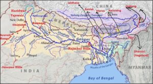
Brahmaputra River Map

 Brahmaputra River

Brahmaputra River System

The river system is located on a continent that is bounded by the Himalayas on the north, the Patkai range of hills on the east, the Assam range of hills on the south, and the Himalayas and ridge on the west. The Brahmaputra river system regions, especially those in Assam, see some of the highest rainfall patterns in the world and are vulnerable to yearly floods and riverbank erosion.

Snow is present in Sikkim and Arunachal Pradesh’s Himalayan Mountain region, which is located in the Brahmaputra basin. Together, the Brahmaputra river system regions make up the majority (55.48%) of the country’s forest cover, making them one of India’s greenest regions.

The largest and oldest inhabited riverine island in the world, as recognised by UNESCO, is Majuli, an island that is also a district of Assam. The Brahmaputra river systems’ hydropower potential has been estimated at 66065 MW. With a 4800 m elevation drop, the Brahmaputra River flows through Tibet over a distance of around 1700 km. In the Assam valley, this average slope of roughly 2.82 m/Km decreases to roughly 0.1 m/Km. the River in the Assam valley naturally becomes braided as a result of this abrupt flattening of the river slope.

The river receives a high sediment load from around 20 significant tributaries on its north bank and 13 (thirteen) on its south bank as it flows through the Assam valley from Kobo to Dhubri. This high sediment load causes braiding. The valley’s tributaries are all rain-fed, foaming with rain, and subject to various flood waves depending on the amount of rainfall in their different catchments.

The South-West monsoon is largely to blame for the precipitation in this area. Only during the monsoon season, which lasts from May to September, does heavy precipitation—amounting to 85% of the yearly total—occur. If the Brahmaputra flood and the flood of the tributaries occur at the same time, it results in significant issues and devastation. The area experiences frequent thunderstorms in the months of April and May, which contributes to flooding in June after heavy rain when the soil is already saturated and the river is in spate.

Brahmaputra River Tributaries

Manas River

One of the Brahmaputra’s most significant tributaries is the Manas River. It starts in Bhutan, travels through Assam and southern Bhutan before joining the Brahmaputra near Jogighopa. The Manas River is 376 kilometres long and is distinguished by mountainous, steep woods in the upper sections and plains around the river’s mouth.

Raidak River

Another tributary of the Brahmaputra in its lower course is the Raidak River. Before merging with the Brahmaputra in the Kurigram area of Bangladesh, it rises in Bhutan in the Himalayas and flows through that country, India, and Bangladesh. The river is 370 km in length overall and is connected by various sub-tributaries in Bhutan.

Sankosh River

It is yet another tributary to the Brahmaputra that rises in Bhutan and empties into Assam, India. In Bhutan, it is referred to as Puna Tsang, and its two biggest tributaries are Mo Chhu and Pho Chhu.

Kameng River

Another significant tributary of the Brahmaputra is the Jia Bhorali River, also known as the Kameng River, which rises in the Arunachal Pradesh district of Tawang from a glacial lake at the Indo-Tibetan border beneath the Gori Chen Mountain. It passes through Arunachal Pradesh, the Assamese Sonitpur district, and Tezpur before finally joining the Brahmaputra.

Dhansiri River

The Dhansiri River is a significant tributary of the Brahmaputra. It begins in Nagaland’s Laisang Peak and runs through the districts of Dimapur and Golaghat before entering the Brahmaputra approximately five kilometres from the Kaziranga Wildlife Sanctuary.

Dihing River

Another significant tributary of the Brahmaputra is the Dihing River. Before joining the Brahmaputra in Dihingmukh, it runs through the Assamese districts of Tinsukia, Dibrugarh, and Arunachal Pradesh, starting in the eastern Himalayas’ Patkai mountain range. Numerous oxbow lakes can be found along Dihing’s route.

Lohit River

Another significant tributary of the Brahmaputra is the Lohit River. Its source is in the Zayal Chu range in eastern Tibet, and it runs through Arunachal Pradesh for two kilometres before it enters the plains of Assam. At this point, it combines with the Siang and forms the Brahmaputra at the head of the valley. Due to the river’s turbulence, it was given the name Lohit.

Tista River

Another tributary of the Brahmaputra is the Tista or Teesta River, which rises in Cholomo Lake in Sikkim and flows across the Himalayan Mountains before entering Bangladesh and joining the Brahmaputra there.

Subansiri River

It is yet another significant branch of the Brahmaputra, a river that rises in China’s Himalayas and runs into Tibet and India. It enters the Brahmaputra in the Lakhimpur district of Assam and is 442 kilometres long.

Bhogdoi River

The Bhogdoi River is another tributary of the Brahmaputra. It rises in the Naga Hills, passes through the Assamese city of Jorhat, then joins a smaller tributary of the Brahmaputra before joining the main Brahmaputra and spilling into it. Together, these two tributaries are referred to as Gelabill. It was formerly referred to as Desoi.

Brahmaputra River flows through which States?

  • Arunachal Pradesh
  • Assam
  • West Bengal
  • Meghalaya
  • Nagaland
  • Sikkim


Brahmaputra River UPSC

Where is the Brahmaputra River located?

The river originates from the Kailash ranges of the Himalayas at an elevation of 5300 M. After flowing through Tibet it enters India through Arunachal Pradesh and flows through Assam and Bangladesh before it joins the Bay of Bengal. The catchment area of Brahmaputra in Tibet is 2, 93,000 Sq.

What is famous in Brahmaputra River?

Known for the beach festival in April, the Brahmaputra riverside offers a cool breeze and a beautiful view to all those who visit. During winter, it is also where you can spot various species of birds. The Kachari ghat is the best place to enjoy the view and ambience of this beautiful attraction in Guwahati.

Is the Brahmaputra the longest river in India?

The Ganges is the longest river in India if we consider the total distance covered by a river within India. The length of the Ganga river is about 2510 km.

Why is the Brahmaputra called the Red river?

The soil of this region is naturally rich in iron content, bringing the colour red to the river with a high concentration of red and yellow soil sediments. That’s why the Brahmaputra River is also called the Red River.

Which is India’s biggest river?

At over three thousand kilometres long, the Indus is the longest river in India as of 2022. It originates in Tibet from Lake Mansarovar before flowing through the regions of Ladakh and Punjab, joining the Arabian Sea at Pakistan’s Karachi port.


Other Indian Geography Topics

Seasons of India Mountains of India
Mangrove Forests in India Important Mountain Passes in India
Monsoon in India
Indus River System
Climate of India
Rivers of India
Tributaries of Ganga
National Parks in India
Important Dams in India
Wildlife Sanctuaries of India
Tiger Reserves in India
Northern Plains of India
Physiography of India
Important Lakes of India
Wetlands in India
Biodiversity in India
Natural Vegetation in India Earthquakes in India
Types of Soil in India
Ramsar Sites in India
Brahmaputra River System
Hydropower Plants in India
Nuclear Power Plants in India
Major Ports in India
Biosphere Reserves in India
Waterfalls in India

Other Fundamental Geography Topics

Solar System Types of Clouds
Structure of the Atmosphere Himalayan Ranges
Component of Environment
El Nino and La Nina
Coral Reef
Continental Drift Theory
Endogenic and Exogenic Forces
Indian Ocean Region
Pacific Ocean
Indian Ocean Dipole
Air Pollution
Environmental Impact Assessment
Tropical Cyclone
Western Disturbances
Types of Rocks


Sharing is caring!

FAQs

Where is the Brahmaputra River located?

The river originates from the Kailash ranges of the Himalayas at an elevation of 5300 M. After flowing through Tibet it enters India through Arunachal Pradesh and flows through Assam and Bangladesh before it joins the Bay of Bengal. The catchment area of Brahmaputra in Tibet is 2, 93,000 Sq.

What is famous in Brahmaputra River?

Known for the beach festival in April, the Brahmaputra riverside offers a cool breeze and a beautiful view to all those who visit. During winter, it is also where you can spot various species of birds. The Kachari ghat is the best place to enjoy the view and ambience of this beautiful attraction in Guwahati.

Is the Brahmaputra the longest river in India?

The Ganges is the longest river in India if we consider the total distance covered by a river within India. The length of the Ganga river is about 2510 km.

Why is the Brahmaputra called the Red river?

The soil of this region is naturally rich in iron content, bringing the colour red to the river with a high concentration of red and yellow soil sediments. That's why the Brahmaputra River is also called the Red River.

Which is India's biggest river?

At over three thousand kilometres long, the Indus is the longest river in India as of 2022. It originates in Tibet from Lake Mansarovar before flowing through the regions of Ladakh and Punjab, joining the Arabian Sea at Pakistan's Karachi port. 

About the Author

I, Sakshi Gupta, am a content writer to empower students aiming for UPSC, PSC, and other competitive exams. My objective is to provide clear, concise, and informative content that caters to your exam preparation needs. I strive to make my content not only informative but also engaging, keeping you motivated throughout your journey!

Leave a comment

Your email address will not be published. Required fields are marked *