
Table of Contents
Bay of Bengal
The Bay of Bengal is the second-largest part of the Indian Ocean after the Arabian Sea. It covers an area of 2,600,000 square kilometers and is about 2090 kilometers long and 1610 kilometers wide. The average depth is 2600 meters with a maximum depth of 4694 meters. It is the largest body of water called a bay in the world.
The Bay of Bengal is located in the northeastern Indian Ocean and is bordered by several countries: India to the northwest and west, Myanmar to the east, Bangladesh to the north, Sri Lanka to the southwest, and Indonesia to the southeast. The Nicobar and Andaman Islands are also along the bay’s eastern side. The bay is home to the world’s largest mangrove forest, the Sundarbans, and the longest beach, Cox’s Bazar. The Bay of Bengal is bordered to the north by a wide continental shelf that narrows toward the south. The northwest, north, and northeast coasts have varying slopes shaped by river canyons. The Ganges, Brahmaputra, Andhra, Mahadevan, Krishna, and Godavari canyons are the most important.
Read More: East China Sea
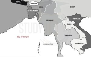
Bay of Bengal Map
Here is the Map of the Bay of Bengal to understand the geographical location of the Bay of Bengal region:
The Bay of Bengal has many islands. Some islands that were above water 80 to 68 million years ago are now underwater, but satellite images still show various islands in the bay.
The most important islands are the Andaman and Nicobar Islands, which separate the bay from the Andaman Sea. The Andaman Islands are about 130.4 kilometers from the southwest coast of Myanmar. Most of these islands belong to India, except for Preparis and Cocos Islands. The Andaman Islands include 572 islands, covering around 6407 square kilometers, with a population of about 343,000 people (as of 2011). The largest island in this group is Great Andaman, which consists of 200 islands, including seven major ones, and covers 4,825 square kilometers.
Bay of Bengal Islands/Countries
The Bay of Bengal is surrounded by several islands, including:
- Andaman and Nicobar Islands: A Union Territory of India, these islands are located in the northeastern part of the Bay of Bengal.
- Sri Lanka: An island country located in the southwestern part of the Bay of Bengal.
- Rakhine State: A state in Myanmar located in the southwestern part of the Bay of Bengal.
- Bangladesh: A country located in the northeastern part of the Bay of Bengal.
- Sumatra: An island in Indonesia located to the southeast of the Bay of Bengal.
- Irrawaddy Delta: A delta region located in Myanmar at the mouth of the Irrawaddy River, which flows into the Bay of Bengal.
Overall, these islands are important for their unique cultures, ecosystems, and resources, and they play a significant role in the region’s economy and livelihoods, particularly through agriculture, fishing, and tourism.
Bay of Bengal Geographic Importance
1. Agriculture’s Lifeline
India is an agricultural country whose agriculture is heavily reliant on rainfall. As a result, the regular monsoon from the South East winds of the Bay of Bengal provides food for the nation. Agriculture is essential for people living along the Bay of Bengal coast and nearby areas. The fertile delta supports many crops, including rice, wheat, maize, jute, sugarcane, and oilseeds. The region is also known for fish, shrimp, and crab farming.
The rivers flowing into the bay provide plenty of water for irrigation, which is important for farming. Agriculture supports millions of livelihoods and plays a big role in the economies of India and Bangladesh. Also, the bay’s coastal ecosystems offer important resources, like fish, that help local communities.
2. Heat Balance
The presence of sea breezes and monsoon winds keeps the national temperature from reaching extremes. The Bay of Bengal heat balance is about how much heat is stored in the surface waters and its impact on the climate around it. This bay is important for studying heat balance because it is one of the largest warm-water bays in the world, and its waters greatly influence the region’s weather and monsoon patterns. The heat balance in the Bay of Bengal is affected by a number of factors, including Monsoon winds, River runoff, Ocean currents and Evaporation.
3. Biodiversity
As a tropical wetland, the Bay of Bengal is home to a variety of species both on and off the coast. The Bay of Bengal is also home to numerous river delta systems and supports a rich diversity of marine and coastal ecosystems. Some of the notable species and ecosystems found in the Bay include:
- Marine Mammals: Dolphins, whales, and dugongs are found in the Bay’s waters.
- Fish: A variety of fish species, including tuna, mackerel, and shark, are found in the Bay.
- Mangrove Forests: the delta region of the Bay is home to extensive mangrove forests, which provide habitat for numerous species of birds, fish, and crustaceans.
- Coral Reefs: the Andaman and Nicobar Islands in the Bay are home to some of the most diverse coral reef ecosystems in India.
- Seagrasses: the shallow waters of the Bay support seagrass beds, which provide important habitats for various species of fish and invertebrates.
- Salt Marshes: the tidal flats in the delta region support salt marsh ecosystems, which provide important habitats for shorebirds and other species.
4. Natural Barrier Against External Aggression
Since ancient times, India has been open to attacks through the Himalayan passes, while the seas have provided a safer side for the country.
Read More: Atlantic Ocean
Bay of Bengal Economic Importance
The Bay of Bengal is important for several reasons:
- This route is used for all sea trade with the east, southeast, and Asia Pacific. As a result, several major ports can be found here.
- It is a source of income for the locals and the authorities because it is a pivotal rest point for trade between the far east and the west.
- The presence of heavy rainfall aids in the growth of tropical evergreen forests in and around the region, which supply a variety of economically viable products ranging from aromatics to fodder to woods to bamboo, and so on.
- It is home to a large percentage of marine resources, which provide a source of income for millions of people. It may also have the potential for offshore hydrocarbon basins.
- Several washouts from various industries are transferred here via rivers, lowering the initial cost.
- It has the potential to build wind and tidal energy power plants.
- Heavy mineral sands are found on the southeastern Indian coast near Chennai and Vishakhapatnam, near Nagapatnam (in Tamil Nadu). Ilmenite, garnet, sillimanite, zircon, rutile, and manganite are among them.
Read More: South China Sea
Bay of Bengal UPSC
The Bay has long been a major commerce hub for the Indian Ocean, acting as a conduit for trade and culture between the East and the West. The Bay region has been significantly impacted by an Indo-Pacific orientation and the realignment of global economic and military power toward Asia.
Read More: Equatorial Climate Region
 Lokmanya Tilak Jayanti 2026: Biography, ...
 Sex Ratio in India 2026: Latest Trends, ...
 Civil Disobedience Movement (CDM): Cause...