Table of Contents
India, known for its diverse climatic zones, is home to both hot and cold deserts. These deserts are not just barren lands but hold ecological, cultural, and geographical importance. This article explores the Deserts of India, includes a desert map, and elaborates on the features of the Thar Desert and the Cold Desert of India.
Deserts of India
Deserts of India: Deserts are dry areas with very little or no vegetation and extreme temperatures either very hot or very cold. Deserts can be hot or cold depending on the climate. People live and farm in these areas where there is little water. Experts agree that a desert is any place with less than 25 cm (10 inches) of rain per year. Deserts are important ecosystems with unique plants and animals adapted to survive in tough conditions.
Deserts usually do not have trees, and shrubs or small plants only cover the ground partially. Some deserts have almost no plants because they are so dry. This dryness can be made worse by human activities, like overgrazing by cattle, which puts extra stress on the environment.
Thar Desert of India
The Great Indian Desert also called the Thar Desert is a large, dry area in the northwest of the Indian subcontinent. It forms a natural border between India and Pakistan and covers about 200000 km². Around 85% of the Thar Desert is in India, and 15% is in Pakistan. The Thar Desert makes up roughly 4.56% of India’s total land area. The Rann of Kutch along the western coast, the alluvial plains of the Indus River in the northwest, Punjab and Haryana to the north, and the Aravali Hills in the northeast make up the Great Indian Desert.
The Thar Desert contains a number of protected areas. Here are a few of them:
- Desert Natural Park: Desert Natural Park has an area of about 3162 km2. It has 44 towns and one of the largest Thar Desert ecosystems, as well as a variety of flora and wildlife.
- Tal Chhapar Sanctuary: The Churu district is home to the 7 km2 Tal Chhapar Sanctuary. A sizable population of foxes, blackbuck, partridge, and other animals reside in the refuge.
- Sundha Mata Conservation Reserve: The 117.49 km2 (45.36 sq mi) Sundha Mata Conservation Reserve is situated in the Jalore District.
| Thar desert | |
| Thar Desert |
|
| Location |
|
| Climate |
|
| Geological Evidence |
|
| Surface Features |
|
| Rivers |
|
| Lakes and Playas |
|
| Vegetation |
|
| Biodiversity: |
|
| Utilization of Groundwater |
|
Features of Thar Desert of India
| Features | Details |
| Sand dunes | The land has a wavy surface with scattered crescent-shaped dunes (barchans) and long, narrow dunes. |
| Barchans | Made of desert sand, barchans are crescent-shaped sand dunes. The fact that a barchan constantly faces the wind is one of its distinguishing characteristics. It develops when there is a lot of sand in the desert. |
| Mushroom Rocks | In a dense montane forest, Mushroom Rocks is a group of huge granite boulders. |
| Shifting dunes |
Locally called Dhrians. |
| Oasis | Mostly in its southern part. |
Thar Desert Characteristics
The harsh environment and sparse vegetation of the desert is called Marusthali, meaning “dead land.” Marusthali is rocky in the east and has shifting sand dunes in the west. The semi-arid area west of the Aravallis is called Bagar. Bagar has a thin layer of sand. The northern part has many salt lakes, while the southern part is drained by the Luni River. There are also several short seasonal streams from the Aravallis in the Rajasthan Bagar region.
In some fertile areas known as Rohi, these streams provide agricultural support. Even the “Luni,” the most significant river, is a seasonal stream. The Luni River begins in the Pushkar valley of the Aravalli Range, close to Ajmer, and flows into the Rann of Kutch in the southwest. The Thali, or sand plain, is located north of the Luni River. Some streams flow for a while and then dry up, joining lakes or playas like Sambhar Lake, showing typical inland drainage. The main source of salt comes from the brackish water in these lakes and playas.
Thar Desert Topography
The soil in the Great Indian Desert is always dry and easily blown away by the wind. Strong winds carry dust from the desert and deposit it near farmland, creating shifting sand dunes. Canals like the Indira Gandhi Canal provide water to the Thar Desert and prevent it from spreading into fertile areas.
Thar Desert Flora and Fauna
Fauna: There is a diverse range of flora and fauna in the Thar Desert. Here are a few examples of fauna:
- Blackbuck
- Wolf
- Indian Wild Ass
- Red Fox
- Chinkara
- Sand Grouse
- Leopard
- Caracal
- Asiatic Wild Cat
- Packcock
Flora: Herbaceous species including cactus, neem, khejri, and acacia nilotica are among those grown in the area. All of these plants can adapt to extremes in temperature and unfavourable environmental circumstances.
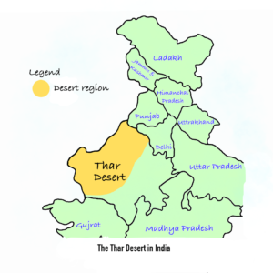
Thar Desert in India Map
Here is the map of the Thar Desert of India:
Cold Desert of India
The Himalayan Region, India’s Cold Desert Cultural Landscape is found, including Ladakh in Jammu and Kashmir (J&K) and Kinnaur in Himachal Pradesh (H.P.) Ladakh, in the Greater Himalayas, is India’s cold desert. It is east of Jammu and Kashmir and borders China. Ladakh is surrounded by the Zanskar mountains to the south and the Karakoram range to the north. The area is very high, with altitudes from 3,000 meters in Kargil to over 8000 meters in the Karakoram. Ladakh is extremely cold and dry, with winter temperatures often dropping below -30°C.
Features of Cold Desert of India
In Ladakh, the altitude ranges from about 3000 meters to over 8000 meters. The Karakoram mountains are around 8000 meters high, while Kargil is about 3000 meters high. Ladakh is very dry and cold because of its high altitude. Night temperatures often drop below -30°C, and in winter, they can go below -40°C. Ladakh gets very little rain only about 10 cm a year, because it is in the rain shadow of the Himalayas. The thin air at high altitudes makes the sun’s heat feel very strong. The cold desert experiences intense sunlight and cold winds.
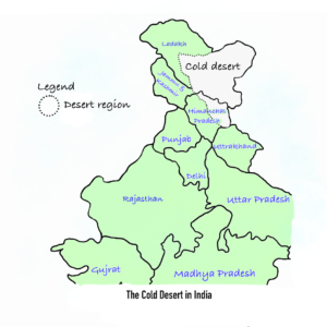
Cold Desert in India Map
Here is the map of the Cold Desert of India:
Deserts of India UPSC Important Facts
- Thar Desert, also called the Great Indian Desert, is the hottest desert in India.
- Ladakh is the cold desert in India.
- The Thar Desert is located northwest of the Aravali hills.
- About 85% of the Thar Desert is in India, and 15% is in Pakistan.
- The semi-arid region of the Thar Desert is called “Bagar”.
- The world’s coldest desert is Antarctica.
- The world’s largest desert is located in Antarctica.
- The Antarctic Desert is colder than the Arctic Desert.
- Antarctica, mainly made up of ice flats, has experienced temperatures as low as -89°C.
 Sex Ratio in India 2026: Latest Trends, ...
 Civil Disobedience Movement (CDM): Cause...
 Role of Teachers in Educations, Student ...