Table of Contents
Context: Shipki La Pass in Himachal Pradesh, previously restricted due to its strategic location on the India-China border, has been opened for border tourism to boost connectivity and local development. Read this article below to get the complete List of Important Mountain Passes in India and their significance with map.
Important Mountain Passes in India
India, a country of varied geography, has many important mountain passes, especially along its north Himalayan and Karakoram ranges, but also the Western and Eastern Ghats. The natural entrances have long been used as pivotal channels for commerce, migration, pilgrimage, and war, essentially defining the nation’s cultural and strategic fabric.
Such passes as the Zoji La linking Kashmir to Ladakh, Himachal Pradesh’s Rohtang Pass opening up roads to Lahaul and Spiti, and Nathu La in Sikkim, an important trade link to Tibet, are not only geographical landmarks but also lifelines that provide connectivity, support economic activity, and are of great strategic value for India’s border security and regional integration.
While certain passes such as Khardung La and Umling La in Ladakh are famous as a few of the world’s highest motorable roads, providing exciting adventure tracks, others such as Palakkad Gap in the Western Ghats offer essential low-lying links between coastal plains and the Deccan plateau, highlighting the multi-faceted utility these mountain routes have in India’s geography and development.
List of Important Mountain Passes in India State-wise
Check here Important Mountain Passes in India state-wise with their name and locations:
Major Mountain Passes in Leh-Ladakh
| Pass Name | Location/Connects |
| Chang La | Leh to Pangong Lake |
| Bara-Lacha La
Known as “Gateway to Ladakh” |
Connects Lahaul and Ladakh via Zanskar Range. |
| Khardung La | Entry to Nubra Valley; Tibetan range |
| Imis La | Ladakh to Tibet; entry to Hanle Valley |
| Zoji La | Dras: connects Kashmir Valley, Indus Valley & Suru Valley |
| Tanglang La | Connects Debring with Gya in Ladakh |
Major Mountain Passes in Jammu and Kashmir
| Pass Name | Location/Connects |
| Karakoram Pass | Karakoram Range; connects India and China |
| Pir Panjal Pass | Kashmir Valley and Rajouri |
| Banihal Pass | Jammu to Srinagar (now bypassed by Jawahar Tunnel) |
| Burzail Pass | Astore Valley (Kashmir) to Deosai Plains (Ladakh) |
| Pensi La | Connects Kashmir with Kargil via Himalayan range |
Major Mountain Passes in Himachal Pradesh
| Pass Name | Location/Connects |
| Shipki La | Kinnaur (Himachal Pradesh) and Tibet |
| Rohtang Pass | Kullu Valley and Lahaul-Spiti |
| Bara-Lacha La | Zanskar Range; connects Lahaul and Leh |
| Debsa Pass | Kullu and Spiti |
Major Mountain Passes in Uttarakhand
| Pass Name | Location/Connects |
| Mana Pass | Connects Mana (Uttarakhand) with Tibet |
| Niti Pass | Connects Uttarakhand and Tibet |
| Lipu Lekh Pass | Tri-junction of Uttarakhand, Nepal, and Tibet |
| Traill’s Pass | Between Pindari and Milam Valleys |
| Mangsha Dhura | Connects Uttarakhand with Tibet |
| Muling La | North of Gangotri, in the Great Himalayas |
Major Mountain Passes in North Eastern States
| Pass Name | Location/Connects |
| Nathu La | Connects Sikkim (India) with Tibet (China) |
| Bom Di La | Connects Arunachal Pradesh to Tibet (Lhasa) |
| Jelep La | Connects Sikkim (India) with Tibet |
| Diphu Pass | On McMahon Line; borders India, China, and Myanmar |
| Dihang La | Connects Arunachal Pradesh and Burma (Myanmar) |
| Pangsau Pass | Connects Arunachal Pradesh with Burma (Myanmar) |
Major Mountain Passes in Western Ghats
| Pass Name | Location/Connects |
| Bhor Ghat | Between Palasdari and Khandala (rail); Khopoli and Khandala (road), Maharashtra |
| Thal Ghat | Mumbai–Nashik Road; connects Kalyan and Kasara, Maharashtra |
| Palakkad Ghat | Connects Tamil Nadu and Kerala; through Nilgiri and Anaimalai Hills |
| Shencottah Gap | Connects Madurai (Tamil Nadu) and Kottayam (Kerala) via Shencottah and Punalur |
What is a Mountain Pass?
A Mountain pass is a route that connects the mountain run. It serves as a link between different parts of the country as well as neighbouring countries for a variety of purposes. Mountain passes are often found just above a river’s headwaters, forming a drainage divide.
A pass may be very short, with steep slopes to the top, or it may be a valley many kilometres long, with the highest point only identifiable by surveying. Zoji La (Pass), Banihal Pass, Shipki La (Pass), Bara-Lacha Pass, Rohtang Pass, Mana Pass, Niti Pass, Nathu La (Pass), and Jalap La are some of the most important passes in the country (Pass).
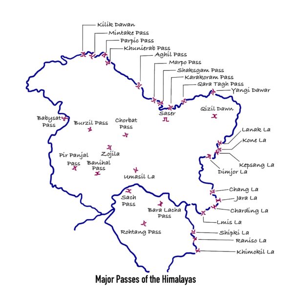
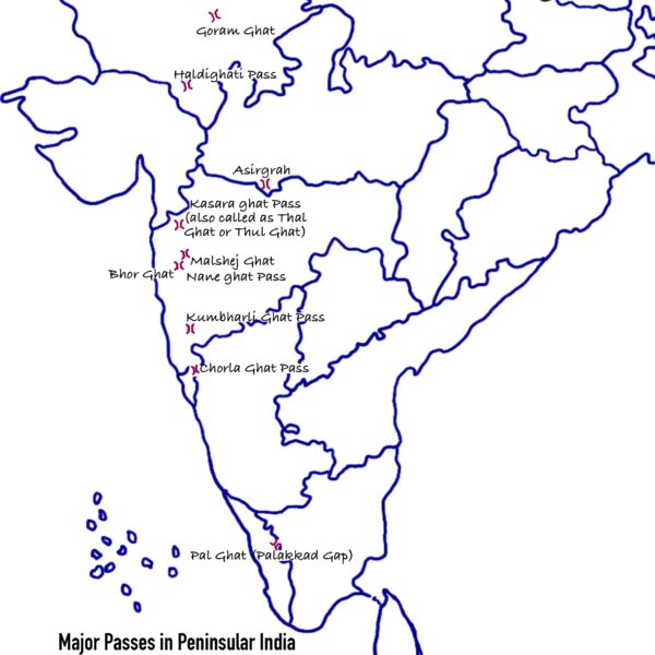
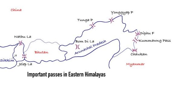
Understanding of Major Mountain Passes in India through Map
Here you can understand of Major Mountain Passes in India through a Map in different region of India:
Major Passes of the Northern Himalayan Region

Major Passes in Peninsular India

Major Passes in Eastern Himalayas

List of Major Mountain Passes in India
| Name of Mountain Passes | Description |
| Umling La | It is the country’s highest motorable pass. It connects Leh to Pangong Lake. |
| Khardung La | It is the country’s second-highest motorable pass. It connects the glaciers of Leh and Siachen. During the winter, this pass is closed. |
| Aghil Pass | It is located in the Karakoram Mountains to the north of Mount Godwin-Austen. It connects Ladakh to China’s Xinjiang province. It is closed from November to May for the winter season. |
| Chang-La | It is a high mountain pass in the Himalayan range. It links Ladakh and Tibet. |
| Lanak La | This is in the Ladakh region, in the Aksai Chin. It links Ladakh and Lhasa. The Chinese government has constructed a road connecting Xinjiang and Tibet. |
| Imis La | The pass’s geographical terrain is difficult, with steep slopes. During the winter, this pass remains closed. It links Ladakh and Tibet. |
| Bara-La/ Bara- Lacha La | It is located on the National Highway in Jammu and Kashmir. It links Manali and Leh. |
|
Lipu Lekh |
It is situated in the state of Uttarakhand. It links Uttarakhand to Tibet. This pass is a vital border crossing point for trade with China. Pilgrims on their way to Manasarovar pass through this pass. |
| Traill’s Pass | It’s in Uttarakhand. It connects the Pindari and Milam valleys and is located at the end of the Pindari glacier. This pass is extremely steep and rocky. |
| Mana Pass: Uttarakhand-Tibet | It connects Tibet and Uttarakhand and is located in the Greater Himalayas. During the winter, it is covered in snow for six months. |
| Muling La | It is located in the Great Himalayas, 5669 metres above sea level, to the north of Gangotri. During the winter, this seasonal pass connecting Uttarakhand and Tibet remains snow-covered. |
|
Mangsha Dhura Pass |
The pass that connects Uttarakhand and Tibet is notorious for landslides. Pilgrims on their way to Manasarovar use this route. It is found in the Kuthi Valley. |
| Niti Pass | This pass connects Uttarakhand and Tibet. During the winter, this is also snow-covered. |
| Debsa Pass | It connects the Spiti and Parvati valleys. It is a high mountain pass in Himachal Pradesh that connects the districts of Kullu and Spiti. It is a Pin-Parvati Pass bypass route. |
| Rohtang Pass | This is situated in the Himachal Pradesh state. Excellent road transportation is available. This pass links Lahul, Spiti, and Kullu. |
| Banihal Pass (Jawahar Tunnel) | In Jammu and Kashmir, Banihal Pass is a well-known pass. The Pir-Panjal Range is where it is located. It links Qazigund with Banihal. |
| Burzail pass: Srinagar- Kishan Ganga Valley | The Deosai Plains in Ladakh and the Astore Valley in Kashmir are connected by this pass. |
| Pir-Panjal Pass | It is a customary pass between Jammu and Srinagar. The partition resulted in the closure of this pass. From Jammu, it offers the quickest access via road to Kashmir Valley. |
| Pensi La | The Pensi La links Kargil and the Kashmir valley. The Greater Himalayas are where it is located. |
| Qara Tagh Pass | The Karakoram Mountains are where you can find it. It was a branch of the old Silk Road. |
| Dihang pass | It is situated in the Arunachal Pradesh region of the Northeast. This pass links Myanmar with Arunachal Pradesh (Mandalay). It allows travel at a height of more than 4,000 metres. |
| Pangsau Pass | It is situated in the Arunachal Pradesh state. This pass links Myanmar with Arunachal Pradesh. |
| Diphu pass | A mountain pass known as Diphu Pass circles the region of the India, China, and Myanmar tripoint border dispute. Another key route into eastern Arunachal Pradesh is via Diphu Pass. The McMahon Line passes beside it. |
| Bomdi-La | Arunachal Pradesh and Lhasa, the capital city of Tibet, are connected by the Bomdi-La pass. It is situated in Bhutan’s eastern region. |
| Nathu La Pass | It is situated in the Sikkim state. This well-known pass, which is on the boundary between India and China, was reopened in 2006. It is a portion of a branch of the old silk route. One of the trading border crossings between China and India is there. |
| Jelep La Pass | The Chumbi valley is traversed by this pass. It links Sikkim and Lhasa, the Tibetan capital. |
| Bhor Ghat | On the summit of the Western Ghats, in Maharashtra, India, there is a mountain pass known as Bhor Ghat, Bor Ghat, or Bhore Ghaut that runs between Palasdari and Khandala by rail and between Khopoli and Khandala by road. Four hundred and forty-one metres above sea level is where it is situated. |
| Thal Ghat | Thal Ghat is a ghat segment (mountain inclination or slope) in the Western Ghats close to the town of Kasara in Maharashtra. It is also known as Thul Ghat or Kasara Ghat. |
| Pal Ghat | Between the states of Tamil Nadu and Kerala, in the Western Ghats, sits the Palakkad Gap. India at a height of roughly 140 metres. The mountain pass links Coimbatore in Tamil Nadu with Palakkad in Kerala. It is situated between the Nilgiri Hills in the north and the Anaimalai Hills in the south. |
| Shencottah Gap | The Western Ghats are where it is situated. It connects the Kottayam district in Kerala with the Tamil Nadu city of Madurai. |


 Critical Minerals, Key Issues, Importanc...
 Grasslands in the World, Map, Types and ...
 Places in News for UPSC 2025 for Prelims...


