Table of Contents
Fronts
A front is a boundary between two different Air Masses. These air masses have different temperatures and moisture levels. When they meet, they can cause changes in the weather. Fronts often bring clouds, rain or snow, and changing winds. The frontal zone sits at a low angle to the Earth’s surface. You can tell it apart by the big temperature differences in the area where the air masses meet and by the curved lines on a weather map.
It is also a zone of low-pressure intensification, cooling of rising hot and humid air, condensation, cloud formation, and Precipitation. The process of forming a new front is referred to as frontogenesis. Frontolysis is the process of destroying, dying or dissolving the front. Due to the Coriolis effect, frontogenesis occurs in the northern hemisphere in an anti-clockwise direction and in the southern hemisphere in a clockwise direction.
Front Meaning
When two different air masses meet the boundary zone between them is called a Front. The cold air mass tends to sink, and the warm air mass tends to rise and this explains why fronts are always inclined. Front development can mostly be found in the mid-latitude region between 30-65 degrees in both hemispheres. The process of formation of the fronts is known as frontogenesis. The process of dissipation of a front is known as Frontolysis. The concept of fronts was propounded by the Norwegian meteorologists- V Bjerkens and J Bjerkens during World War I. Fonts can be broadly classified into four types depending on their interaction.
Frontogenesis
The term frontogenesis, introduced by Norwegian meteorologist Tor Bergeron, describes how new fronts form. It now also includes the renewal of old or fading fronts in the atmosphere. Frontogenesis occurs where different air masses meet. In contrast, frontolysis refers to the weakening or disappearing of fronts, making it the opposite of frontogenesis. Fronts do not form suddenly they develop over time through frontogenesis. Similarly, the weakening of existing fronts happens gradually and requires time to fully disappear.
Frontogenesis Necessary Conditions
The Conditions for Frontogenesis are:
- Two different air masses are needed with contrasting temperatures, pressure, density, and humidity.
- One air mass is cold, dry, and heavy.
- The other air mass is warm, humid, and light.
- The cold, dense air moves into the area of the warm air.
- The air masses should either move in the same direction or come together.
- If they separate and move apart, no new fronts will form.
Read More: Tropical Cyclone
Front Types
There are four types of weather fronts:
- Stationary fronts,
- Cold fronts,
- Warm fronts, and
- Occluded fronts
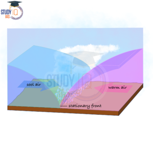
1. Stationary Front
A stationary front happens when two different air masses meet but don’t mix. Neither air mass can push the other, so they stay still. The wind flows parallel to the front but in opposite directions. These fronts are usually temporary and don’t last long.
Weather along a Stationary Front
It produces Cumulonimbus Clouds. Frontal precipitation results from warm air overrunning along a front like this. Cyclones moving along a still front can produce substantial flooding along the front by dumping large volumes of precipitation.
Read More: Types of Clouds
2. Warm Front
When a warm air mass moves towards a cold air mass, the contact zone is a warm front. As the warm air ascends the slope it condenses and causes precipitation. The warm front has a gentle slope of 1 km of rise for every 100 or 200 km of distance.
1. Weather along a Warm Front
In contrast to a cold front, the temperature and wind direction changes are gradual as the warm air flows up the slope, causing condensation and precipitation. These fronts bring about light to moderate precipitation across a wide area and for several hours. A rise in temperature, a drop in pressure, and a shift in the weather signal the passing of a warm front.
2. Clouds along a Warm Front
The hierarchy of clouds as we approach is cirrus, stratus, and nimbus. There are no cumulonimbus clouds due to the mild gradient. The sun and moon are surrounded by cirrostratus clouds that are in front of the warm front.
Read More: Pressure Belts
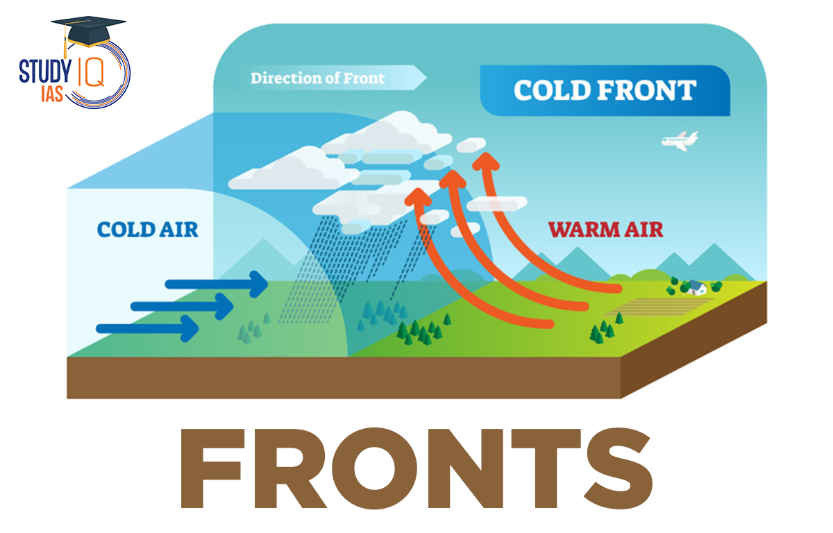
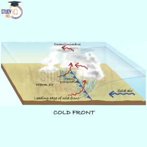
3. Cold Front
It is a front in which the cold air is moving towards the warm air zone. As the cold air mass is dense, it remains on the ground. The cold air mass forcibly uplifts the warm and less dense air mass. The front is associated with a narrow band of clouds and precipitation. The cold front has a steeper slope than the warm front. It has a slope of 1 km of rise for a 50 or 100 km of distance.
1. Weather along a Cold Front
- The narrow zone of cloudiness and precipitation that runs along such a front determines the weather.
- Storms with high winds are possible. Thunderstorms are frequent in the warm sector during the summer.
- Tornadoes can occur in warm places, such as the United States.
- Cause whether to change more abruptly. Within the first hour, temperatures might drop by more than 15 degrees.
2. Cloud Formation along a Cold Front
Increased wind activity in the warm sector and the arrival of cirrus clouds, followed by lower, thicker altocumulus and cirrus clouds, signal the approach of a cold front. Heavy downpours are brought on by cumulonimbus and black nimbus clouds at the front. A cold front quickly dissipates, but the weather it causes is severe.
Read More: Atmospheric Circulation
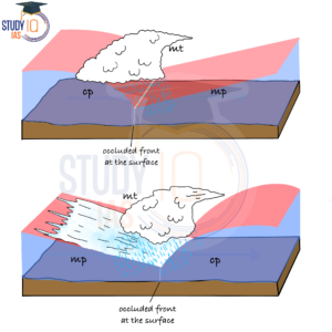
4. Occluded Front
An occluded front forms when a cold front catches up to a warm front. The cold front moves faster, reducing the area of warm air until it is completely pushed out. The cold and warm fronts then combine to create a long, backward-swinging front called an occluded front. The weather in an occluded front can be unpredictable, often bringing erratic rainfall.
1. Weather along an Occluded Front
A complex combination of a cold front and warm front weather exists along an occluded front. West Europe frequently experiences such fronts. the structure Occluded fronts emerge during the development of mid-latitude cyclones, often known as temperate or extratropical cyclones.
2. Clouds along an Occluded Front
At both the cold front and warm front, different types of clouds form. On the opposite sides of the occlusion, you will find clouds from the cold front and clouds from the warm front.
Read More: List of Major Local Winds
Front Climatic Significance
The weather changes when a front passes through a region. Weather conditions like rain, thunderstorms, strong winds, and tornadoes are brought on by the phenomenon. A cold front may bring about violent thunderstorms. There can be low-stratus clouds at a warm front. After the front has passed, the skies often clear.
Other frontogeneses only change the temperature; nevertheless, some front forms can initiate the biggest storms on Earth. Off the coast of Africa, in the tropical Atlantic Ocean, a front known as tropical wave forms. If the conditions are right, these can also intensify into hurricanes or tropical storms.
They travel across the surface of the Earth over several days, and powerful winds like Jet Streams are frequently used to direct their motion. Mountains and other land features can alter the convergence’s route.
Read More: Types of Winds
Fronts UPSC
The interface or transition zone between two air masses with varying densities and temperatures; intermittent weather flare-ups along this zone, including sporadic thunderstorms and electrical activity, were compared by the Norwegian meteorologists who gave it its name during World War I to the fighting along the front lines in Europe. Frontal zones frequently include low barometric pressure (a pressure trough), notable changes in wind direction and relative humidity, as well as a great deal of cloud cover and precipitation.
In this article, we have addressed a number of topics that are crucial for the UPSC test, including the definition of the front, different types of fronts, stationary fronts, cold fronts, warm fronts, occluded fronts, and prerequisites for frontogenesis.
 Sex Ratio in India 2026: Latest Trends, ...
 Civil Disobedience Movement (CDM): Cause...
 Role of Teachers in Educations, Student ...