Table of Contents
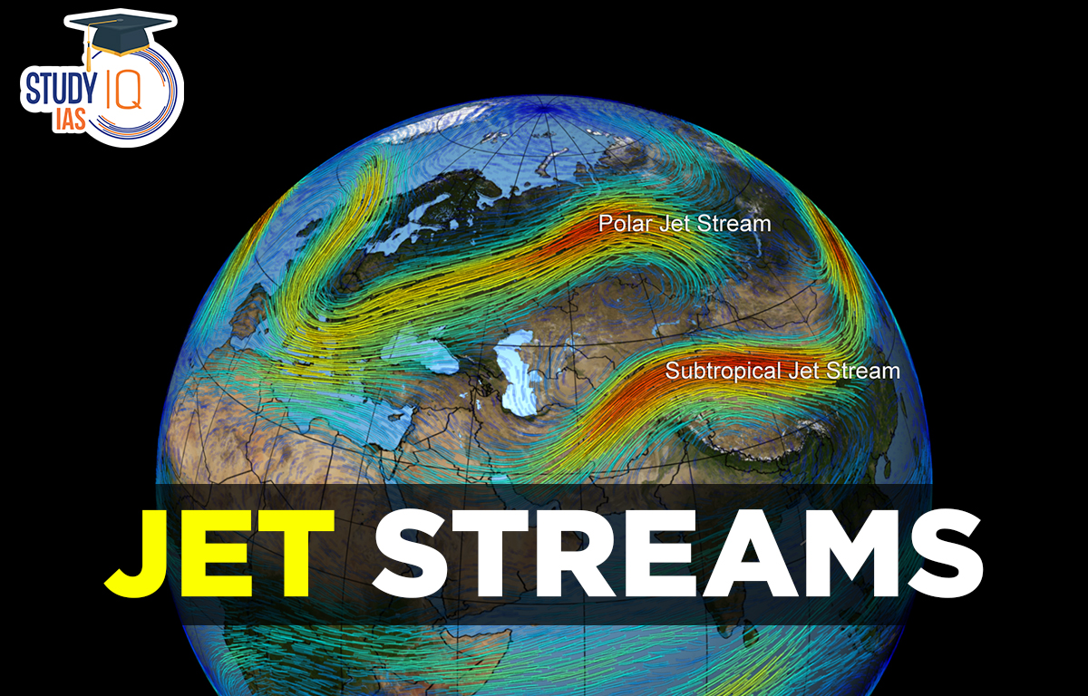
Jet Streams
Jet streams are fast-moving air currents high above the Earth, at altitudes of about 8 to 15 kilometers. They form when there are big temperature differences in the atmosphere.
Air currents are movements of air within larger bodies of air, created by the uneven heating of the Earth by the sun. The tropics get warmer than the poles, causing the warm air above to rise. This creates warm air currents, while cooler, heavier air moves in to take its place, forming cool air currents. Jet streams are simply the fastest air currents in the upper atmosphere.
Read More: Types of Winds
Jet Streams Formation
At high altitudes near the top of the troposphere, jet streams are narrow bands of strong winds. In summer, they move at about 110 km/h, while in winter, speeds exceed 180 km/h. They have a wavy shape, with winds slowing down as they spread out. Jet streams are a few hundred kilometers wide and 2 to 5 kilometers deep, and their flow isn’t always straight; this wavy movement is called Rossby waves.
These waves can dip, rise, split into smaller loops, or even disappear and reappear elsewhere. Jet streams “follow the sun,” shifting northward in spring and southward in autumn as the sun’s height changes. Sometimes, jet streams reach into the lower stratosphere, bringing water vapor that can form cirrus clouds. Their effects can be felt as low as 3 km above the ground, and wind strength varies along their path. In winter, the strongest winds are over the eastern Atlantic and Pacific Oceans, while in summer, they are stronger around the Canadian border and the Mediterranean Sea.
Read More: List of Major Local Winds
Jet Streams Characteristics
- The thermal contrast of air cells like Hadley cells and Ferrel cells is a factor in their origin.
- The ‘Rossby Wave’ refers to the Jet Stream’s meandering or whirl movement.
- Because of the southern shift of the pressure belts, the equatorial extension of the Jet Stream is greater in winter.
- During the winter, thermal contrast increases, as does the intensity of the high-pressure centre at the pole. It accelerates the formation of Jet Streams, as well as their extension and velocity.
Read More: Pressure Belts
Jet Stream Climatic Significance
- Jet Streams occasionally bring moisture to the stratosphere, resulting in the formation of Noctilucent clouds (tenuous cloudlike phenomena in the upper atmosphere which are made of ice crystals visible in a deep twilight.
- It plays an important role in starting and ending monsoon winds.
- It has contributed to putting some harmful substances into the stratosphere, which harms the ozone layer.
- Its movement creates cycles of stormy (cyclonic) and calm (anticyclonic) weather conditions.
- As the air mass moves, it expands and compresses, leading to changes in high and low pressure.
Read More: Atmospheric Circulation
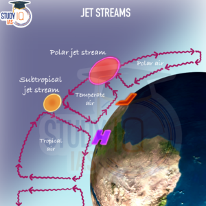
Types of Jet Streams
Each hemisphere has two zones with a persistent jet stream. One is a subtropical jet stream, and another is a polar front jet stream. Another jet stream circulates periodically close to the equator.
1. Polar Front Jet Stream
It originated because of temperature differences.
- Association: Linked to the polar front zone in each hemisphere
- Meandering: Meanders more than the Sub-Tropical Jet Stream
- Location: Extends between 40° and 60° latitudes in both hemispheres
- Altitude: Found at heights between 6 km and 9 km in the atmosphere
- Seasonal Movement: Swings towards the poles in summer and towards the equator in winter
- Cold Air Transport: Brings very cold air to subtropical regions when moving south
2. Subtropical Jet Stream
The Subtropical Jet stream flows constantly
- Location: Runs between 25° and 30° latitudes in both hemispheres:
- Speed: Slower than polar jet streams
- Air Currents: Air near the equator descends at 30° N and S latitudes
- Sub-Tropical Jet Stream: Part of these air currents becomes the Sub-Tropical Jet Stream
- Seasonal Movement: Swings north of the Himalayas in summer in North India
- Significance: Plays a key role in the monsoons
3. Eastern Tropical Jet Stream
Tropical Easterly Jet Stream is a Seasonal jet stream:
- Location: Between the equator and 20° N latitude
- Occurrence: Active during the South-West Monsoon in summer
- Regions Affected: Southeast Asia, India, and Africa
- Direction: Flows in the eastern direction (opposite to other two jet streams)
- Altitude: Located at higher altitudes, between 14 km and 16 km
- Speed: Approximately 180 km/h
Read More: Atmospheric Pressure
Jet Streams Diagram
A sustained jet stream exists in two zones in each hemisphere. A polar front jet stream and a subtropical jet stream are two examples. Near the equator, another jet stream recurs periodically. Here is an illustration of the Types of Jet streams.
Read More: Chemical Weathering
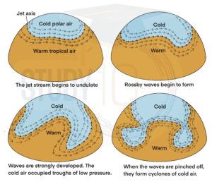
Jet Streams Index Cycle
There are four stages of the Index Cycle of Jet Streams.
| Stage | Details |
| Stage 1 | A convergence between the cold air in the poles and warm air from subtropics in the subpolar low-pressure belt is formed. The thermal contrast and differences in the physical properties restrict the masses from mixing up. Thus, a zone of stationery is created between these two air masses. The path of jet streams is straight. |
| Stage 2 | The cold polar air mass is pushed by the easterlies and warm air is pushed by the westerlies. The straight path gradually gets wavy and meanders, leading to the formation of curvy waves. These curvy waves are known as Rossby waves. |
| Stage 3 | The cold and warm air masses further invade each other’s territory and the waves further meander. The jet stream fully meanders and is positioned near the equator. Now the pressure gradient is east to west. There is a displacement of tropical air mass to the poles and the polar air mass to the tropical areas. |
| Stage 4 | The cut-off of the meanders of the jet stream from the main path occurs due to very high meandering circulation and gives rise to several cellular circulations of cyclonic and anticyclonic patterns. |
Index Cycle of Jet Streams Diagram
There are four stages of the Index Cycle of Jet Streams. Below is an illustration of the Index Cycle of Jet Streams:
Read More: Biological Weathering
Jet Streams Consequences
Jet streams have a significant impact on the weather because they direct the movement of high and low-pressure systems while also preventing the movement of upper-level moisture and energy. Jet streams do not usually move in straight lines; their paths are typically meandering.
Jet Streams & their Influence on Weather Conditions
Jet streams severely affect weather conditions. They substantially contribute to originating cyclones, anticyclones, storms and depressions and influence their behaviour. The cyclones intensify when the jet streams are positioned above temperate cyclones. These jet streams are still being investigated with respect to their effect on weather conditions.
Jet Streams and Air travel
If the weather is not disturbed the aeroplanes running in parallel directions gain great speed and considerably save fuel. Sometimes aeroplanes cannot be flown in the opposite direction. The violent wind shear within the jet streams poses a major threat to air travel. The east-flying flights take less flying time than the west-flying flights.
Jet Streams & their Influence on the Indian Monsoon
The bursting of the Monsoon in India is closely related to Eastern Tropical Jet streams. In summer the subtropical jet streams tend to deflect northwards and cross the Himalayan Range. The altitude of the mountains hinders the jet streams but once cleared, results in the advent of monsoon. This is explained in detail in the monsoon chapter.
Read More: Mass Movement
Jet Streams Important Facts for UPSC
- The westerly Jet Stream is a cold wind that pushes downwind to the surface, creating high pressure.
- The dry winds from this high-pressure area (northwestern India) begin to blow towards the low-pressure area (Bay of Bengal).
- These winds, in turn, bring cold waves in the northern part of the country, including UP and Bihar, during the winter.
- After reaching the Bay of Bengal, westerly winds become northeast monsoons due to the influence of Ferrel’s cell.
- When this wind reaches the coast of Tamil Nadu, the humidity from the Bay of Bengal causes rain.
 Sex Ratio in India 2026: Latest Trends, ...
 Civil Disobedience Movement (CDM): Cause...
 Role of Teachers in Educations, Student ...