Table of Contents
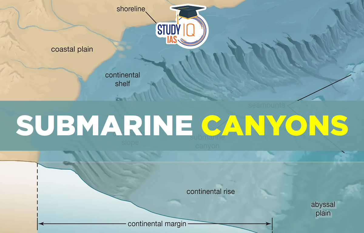
Submarine Canyons
Submarine canyons are narrow, steep valleys that are found on the ocean’s continental slopes and rises. They usually form on the continental shelf and are less common where the slopes are very steep. Submarine Canyons are named after the canyons formed by rivers on land. Undersea canyons are located along the slopes of most continental margins, unlike deep-sea trenches, which occur where one tectonic plate goes under another. They form from erosion caused by sediments carried down by rivers that flow over the continental shelves and slopes. These sediments eventually settle on the abyssal plains.
Read about: Mid Oceanic Ridge
Submarine Canyons Characteristics
Submarine canyons are more often found on steep, active coastlines than on gentle, passive ones. They can erode different types of materials, from loose sediment to solid rock. Canyons on active margins are usually steeper, shorter, and closer together. Their walls are very steep and can be nearly vertical, but they can also wear away and collapse. There are about 9477 submarine canyons around the world, making up about 11% of the continental slope.
- Oceanography is the study of the oceans and seas covering their physical and chemical properties, geologic features, and the life forms that live in them. It has four main branches: physical oceanography, chemical oceanography, marine geology, and marine ecology.
- Marine geology focuses on the geology of the ocean floor, including sediment layers and the study of seafloor spreading. This research helps scientists understand Earth’s history, climate changes, and the effects of pollution on ocean waters.
Read about: Major Ocean Relief Features
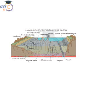
Submarine Canyons Diagram
Submarine Canyons Types
These marine features are formed due to erosional, depositional and biological activity. They are generally found in the upper parts of the elevations since they are produced upon features of diastrophic origins. There are broadly three types of submarine canyons:
1. Bank
A bank is a flat-topped elevation, usually located in the continental margins. Erosional and depositional activities are the major factors for the formation of banks. There’s a shallow layer of water over the bank, but it’s deep enough for boats to pass. These areas are great for fishing, like the Dogger Bank in the North Sea and the Grand Banks in the North-Western Atlantic.
2. Shoal
A shoal is a buildup of sediment in a river or on a continental shelf that can be risky for ships. It is usually considered to be less than 10 meters underwater at low tide on the continental shelf.
3. Reef
A Coral Reef is a ridge or hummock formed in shallow ocean areas by algae and calcareous skeletons, usually coral polyps. A coral reef has the potential to become a permanent coral island. Coral reefs also known as “rainforests of the sea,” are home to a diverse range of organisms. Coral reefs are a characteristic feature of the Pacific Ocean, associated with seamounts and guyots.
Read about: Continental Drift Theory
Submarine Canyons UPSC
The motion of seawater is controlled by ocean relief. In turn, oceanic movement in the form of currents causes many variations in both the oceans and the atmosphere. Ocean bottom relief also has an impact on navigation and fishing.
Read about: Indian Ocean Dipole
 Sex Ratio in India 2026: Latest Trends, ...
 Civil Disobedience Movement (CDM): Cause...
 Role of Teachers in Educations, Student ...