Table of Contents
Major Ocean Relief Features
The ocean conceals a wide range of landscapes that are very similar to those found on the continents. Mountains, basins, plateaus, ridges, canyons, and trenches can be found beneath the ocean. Ocean relief or submarine relief refers to these relief features found on the ocean floor. Ocean basins are divided into four Major Ocean Relief Features. They are:
- Continental Shelf
- Continental Slope
- Continental Rise
- The Ocean Deeps/Abyssal Plains
Read More:Oceanography
Major Ocean Relief Features Diagram
Continental Shelf, Continental Slope, Continental Rise and Abyssal Plains are the Major Ocean Relief Features that are shown below in the diagram. 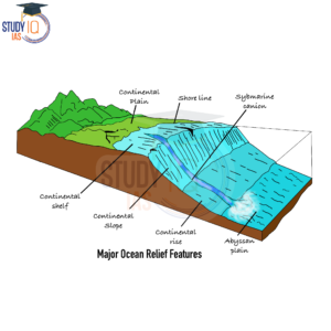
Continental Shelf Relief Features
The Continental Shelf is the land adjacent to the coast that is submerged. Most of the continental shelves represent continental land that has been inundated by the rise in seawater levels. Geologists regard their formation for the following reasons:
- Submergence of boundaries of the continent,
- Erosional work of the waves
- Extension of land from the sediments deposited by rivers.
Read about:Pacific Ocean
Characteristics of the Continental Shelf
- Continental shelves account for approximately 7.5 per cent of the total ocean bottom. It is shallow, with water above the shelf that is usually 60 to 100 fathoms deep (1 fathom equals 6 feet).
- It is broad where the mountains are away from the coast, for example, in northwest Europe and eastern North America; it is narrow where the mountains are nearer to the coast, for example, in Western North America and South America.
- The continental shelf has an average width of 70 kilometres.
- The widest shelf can be found along the glaciated coast of Siberia, where it stretches for about 800 miles.
- Along the continental shelves, shallow seas and gulfs can be found.
The shelf region is a transition zone between freshwater runoff from land and the more saline water of the sea; as a result, it is a region of high water mixing and generally unstable water conditions. Due to limited depth, the oceanic currents usually run parallel to the shore in this region. The presence of shallow water over the shelf enables sunlight to penetrate, encouraging the growth of microscopic plants and animals called plankton. These planktons are food for the fish. Continental shelves provide rich fishing grounds, e.g., the Grand Bank, of New Foundland in North America, and Dogger Bank in the North Sea. Apart from minerals, sand, and gravel, continental shelves are a great source of petroleum and natural gas. E.g., Bombay High, Persian Gulf, North Sea, Gulf of Florida, etc. Around 20% of the petroleum and gas production comes from the shelves. These sites are also rich in placer and phosphorite deposits.
Read about:Indian Ocean
Continental Slope Relief Features
The Continental Slope becomes much steeper at the seaward edge of the continental shelf. The gradient of the slope region varies between 2 and 5°. This declining gradient is called the continental slope; it forms the edge of the continental block. The slope links the continental shelf and the deep seafloor. The continental slope resembles a cliff where heavy rains have eroded. These canyons are thought to have been formed (or cut out) by dense turbidity currents, sediment-laden currents that flow along the ocean floor. Its most striking features are the submarine canyons prevalent along the slope face. Some of these canyons are larger than the Grand Canyon. Large amounts of sediment are deposited and spread out in a fan-like pattern at the seaward end of these canyons to form the continental rise.
Characteristics of the Continental Slope
The depth of the slope region ranges from 200 to 3,000 metres. It is characterised by thick sediment deposits that cover irregular relief features. The continental slope deposits gently seaward, forming the abyssal plains of the deep ocean basins.
Read More: Ocean Currents
Continental Rise Relief Features
The continental slope loses its steepness with depth. When it reaches a level of between 0.5 to 1 degree, the slope is referred to as the continental rise. The continental rise becomes virtually flat with the increasing dept. It merges with the abyssal plains. Read More:Siberian Type Climate
Abyssal Plains or Deep Sea Plain
The Abyssal Plains start beyond the continental rise. They are formed by the accumulation of sediments on the seafloor. Many rugged relief features, such as seamounts, guyots, atolls, sills, and trenches, are superimposed on this very flat plain.
Characteristics of Abyssal Plains
Ocean basins cover 76 per cent of the ocean floor. Its depth varies from 3000 to 5000 m. Read More:Savanna Climate
Major Ocean Relief Features UPSC
The term “relief” is used by geographers to describe the shape of the land, including its height and steepness. To depict relief on topographic maps, cartographers use spot heights, contour lines and patterns, layer colouring, and landform shading.
 Sex Ratio in India 2026: Latest Trends, ...
 Civil Disobedience Movement (CDM): Cause...
 Role of Teachers in Educations, Student ...