Table of Contents
Latitudes and Longitudes
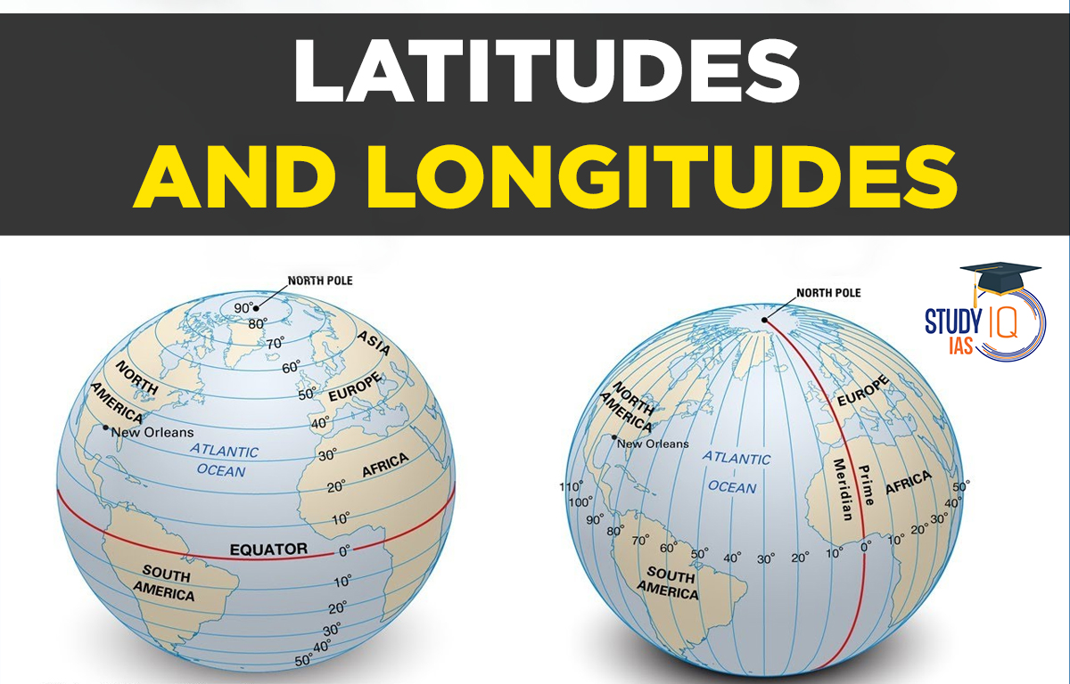
Latitudes and Longitudes are fictitious lines that are used to pinpoint a location on Earth. The earth is geoid in shape. Latitudes and longitudes can be used to describe a location on the earth.
Any position on the surface of the Earth can be located and its position established using the coordinate system of latitude and longitude. Example: New Delhi is located at 28° N and 77° E.
Latitudes
- Latitude is the angular distance of a location on the surface of the earth from its centre, expressed in degrees. Latitude refers to the distance north or south of the Equator on a globe or map. The linear distance of a degree of latitude at the pole is a tiny bit longer than that at the equator due to the earth’s minor flattening at its poles. For instance, it is 68.704 miles at the equator (0°), 69.054 miles at 45°, and 69.407 miles at the poles. The typical distance is 69 miles (111km). A mile is 1.607 kilometres.
- There are three main types of latitude in theory: geocentric, astronomical, and geographic (or geodetic), although these distinctions are negligible. The term “geocentric latitude” is typically assumed.
- Geocentric latitude is the arc subtended by an angle at the Earth’s centre and is measured in a north-south plane poleward from the Equator. It is given in degrees, minutes, and seconds. As a result, a point at 30°15′20′′ North subtends an angle of 30°15′20′′ at the planet’s centre. The maximum possible latitudes are 90° N and 90° S since the arc between the Equator and each geographic pole is 90° (one-fourth the circumference of the Earth, or 1/4 360°). Equidistant circles are plotted and drawn parallel to the Equator and each other; they are referred to as parallels, or parallels of latitude, as tools to represent various latitudinal positions on maps or globes.
Important Parallels of Latitudes
In addition to the equator (0°), and north and south poles (90°N and 90°S, respectively), there are four significant parallels of latitude-Tropic of Cancer is located at 231/2 degrees North. The Tropic of Capricorn is located 231/2° South. 661/2 degrees north of the equator is the Arctic Circle. 661/2 degrees south of the equator is the Antarctic circle.
Latitudinal Heat Zones of the Earth
At least once a year, the midday sun lies directly overhead at all latitudes between the Tropics of Cancer and Capricorn. As a result, this region is known as the torrid zone and receives the most heat. Anywhere north of the Tropics of Cancer and Capricorn, the midday sun never rises overhead. As you get closer to the poles, the sun’s rays’ angle continues to decrease. Because of this, the regions between the Tropic of Cancer and the Arctic circle in the north and the Tropic of Capricorn and the Antarctic circle in the south both have temperate climates.
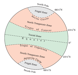
As a result, these are referred to as temperate zones. In both the northern and southern hemispheres, regions between the Arctic Circle and the North Pole, as well as the Antarctic Circle and the South Pole, are extremely cold. It’s because the sun doesn’t rise very high in this area. As a result, its beams are constantly angled. As a result, these are referred to as frigid zones.
Read More: Mountains of India
Longitudes
Longitude is an angular distance down the equator, east or west of the Prime (or First) Meridian, expressed in degrees. Longitude is depicted on a globe as a series of semicircles that extend from pole to pole and pass through the equator. Any meridian may have been used to start the numbering of longitude, unlike the equator, which is centrally located between the poles. International consensus ultimately led to the choice of the zero meridian passing via the Royal Astronomical Observatory in Greenwich, close to London, in 1884. All other meridians radiate eastward and westward up to 180° from this Prime Meridian (0°).
The meridians of longitude, which converge at the poles, enclose a smaller region as the parallels of latitude get shorter as you move poleward. They perform a single, crucial task: they establish local time with respect to G.M.T., often known as world time or Greenwich Mean Time.
Longitude and Time
The earth rotates 360° in a day or 24 hours, therefore it travels through 15° in an hour, or 1° every 4 minutes. Since the planet rotates from west to east, local time advances by an hour for every 15 degrees east. On the other hand, local time is advanced by one hour if we move westward. This leads us to the conclusion that locations east of Greenwich experience the sun earlier and gain time, whilst that west of Greenwich experience the sun later and lose time. Knowing G.M.T makes determining local time as simple as adding or subtracting the number of hours from the specified longitude.
Standard Time Zones
There would be a significant discrepancy in local time between towns if each one kept the time of its own meridian. If they wanted to maintain their appointments while travelling from one end of the country to the other, they would have to continue switching their watches. This is both unnecessary and inconvenient.
All nations observe a common time system in order to prevent these issues. The majority of nations base their standard time on their country’s central meridian. It would be inconvenient to have one time zone in major nations like Canada, the United States, China, and the USSR. As a result, many nations have numerous time zones. Both Canada and U.S.A. have five time zones—the Atlantic, Eastern, Central, Mountain and Pacific Time Zones. The difference between the local time of the Atlantic and Pacific coasts is nearly five hours. S.S.R had eleven time zones before its disintegration. Russia now has nine time zones.
Map with Latitudes and Longitudes
Here is the World Map with Latitudes and Longitudes:

International Date Line (IDL)
From Greenwich, a traveller heading east gains time until he reaches the 180°E meridian, at which point he will be 12 hours ahead of G.M.T. Similarly, he loses 12 hours moving west when he reaches 180°W. The two sides of the 180° meridian are thus separated by a total of 24 hours or a whole day.
The date changes by exactly one day when it crosses this International Date Line. A traveller who crosses the date line from east to west loses a day due to the passage of time and gains a day when doing so from west to east due to the passage of time encountered.
Read More: Nuclear Power Plants in India
Why is the International Date Line not straight?
The Pacific Ocean contains the International Date Line (IDL). Like latitude and longitude, it is a fictitious line. There is a 24-hour difference in time on either side of this line. As soon as one passes this line, the date so changes. Some island chains, including Polynesia, Melanesia, and Micronesia, are located on either side of the dateline.
Therefore, two areas of the same Island Country or Island group would be assigned to distinct date zones if the dateline were straight. This line is drawn through where the sea lies rather than the land in order to prevent any date mistake. As a result, the IDL is depicted in a zigzag pattern.
Read More: Himalayan Ranges
Indian Standard Time (IST)
The meridian of 82.5° east, which is 5 hours 30 minutes ahead of Greenwich Mean Time, has been accepted by the Indian government for standard time.
Chaibagaan Time
The “chaibagaan time” or “bagaan time” that tea plantations followed 150 years ago was established by British colonialists and was one hour earlier than IST. This was done to maximise the use of daylight and increase production. Assam has been adhering to IST for the past 66 years, along with the rest of India, since India’s independence. To save energy and increase productivity, the government of the Indian state of Assam now wants to return to Chaibagaan time. The Indian government rejected the suggestion.
 Astronomy in the Atacama Desert: Telesco...
 Why Below-Average Rains Don’t Rule Out...
 Mahanadi River: Location, Major Tributar...