Table of Contents
India Nepal Border Dispute
India and Nepal, which share an open border, have had a mixed relationship, swinging from friendly to tense. The relationships mostly between them are close and rooted in shared history, culture, tradition, and religion. These ties are evident in their political, social, cultural, religious, and economic interactions. They established formal diplomatic relations on June 17, 1947. One major dispute is over the Kalapani border area, which can affect their economic ties and security. If India and Nepal don’t resolve this issue, it could allow countries like China to get involved.
Read More: India Pakistan Border Dispute
India-Nepal Border Area
The 1770 km long border includes the Himalayan territories as well as Indo-Gangatic Plain. Following the Sugauli treaty between the British and Nepal in 1816, the present boundary was established. Five states of India share the boundary with Nepal they are Uttarakhand, Uttar Pradesh, Bihar, West Bengal and Sikkim.
At present both India and Nepal have a border dispute over regions such as; Kalapani, Lipulekh Trijunction between India, Nepal and China, Susta Region of West Champaran (Bihar).
Read More: India-China Border Dispute
Kalapani region in Indian territory
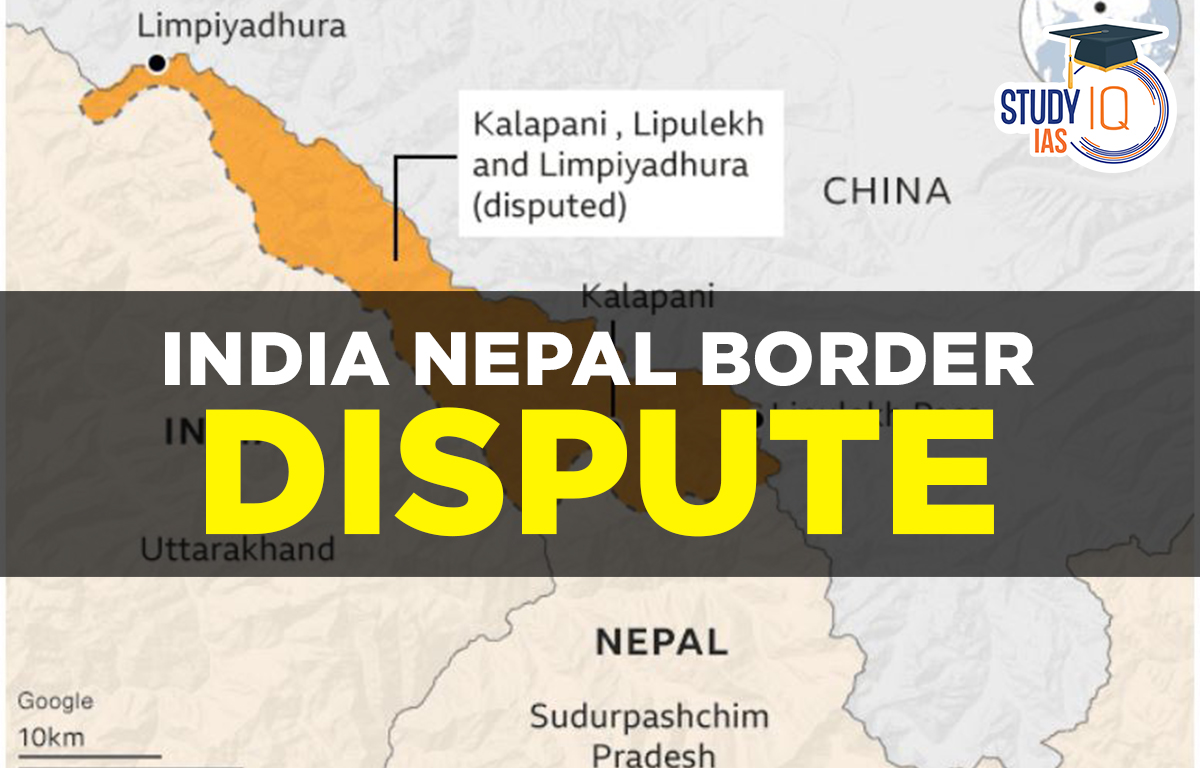
India released a new political map showing Jammu and Kashmir and Ladakh as union territories. This followed the revocation of special status for Jammu and Kashmir in August 2019. The map included the disputed Kalapani region, which India claims as part of Uttarakhand. Nepal objected, stating it belongs to its Darchula district.
The disagreement centers on the origin of the Kali River, which is key to both countries’ claims. Nepal claims the river starts at Limpiyadhura, while India argues it begins further south. Historical maps complicate the issue, with differing origins cited over time.
The open border between India and Nepal allows free movement of people and goods, fostering economic ties. However, the border also faces challenges, including smuggling and security concerns.
Both countries have attempted to resolve border disputes since the 1950 Treaty of Peace and Friendship, but many issues remain, including Kalapani. With China as a neighbor, the situation is sensitive, and both nations need to engage in diplomatic dialogue to resolve disputes peacefully and strengthen relations.
India-Nepal Border Conflicts
Since the 1962 Sino-Indian War, Kalapani has been administered by India. Nepal’s claims to Kalapani trace back to the Treaty of Sugauli, signed in 1816 between the Kingdom of Nepal and British India. This treaty established the Kali River as the boundary between the two countries in the region. But due to a lack of clarity and no consensus on what is the precise location of the river, there has been a dispute between the two countries about whether the land consisting of Kalapani, Limpiyadhura and Lipulekh is part of India or Nepal.
Susta Region
The region named Susta is located on the bank of the Gandak River (it is called Narayani River in Nepal) the prominent reason for the dispute in the Susta region is the changing course of the Gandak River.
Read More: Jammu & Kashmir
India Nepal Border Dispute of Kalapani
Kalapani is located in the easternmost corner of the Uttarakhand district of Pithoragarh at a height of 20000 ft, it is situated on the Kailash Mansarovar route. River Kali in the region of Kalapani demarcates the border between both the country.
The reason the boundary dispute between India and Nepal occurred was due to differences between the source location of the kali river, as each country produced maps supporting their own claims over the region.
India’s Stand on Kalapani Dispute
The Sugauli Treaty does not define the territory north of these streams because the Kali River originates in springs that are located far below the Lipu-lekh pass. The nineteenth-century administrative and revenue records also demonstrate that Kalapani was on the Indian side and was included in the Pithoragarh district of Uttarakhand.
Nepal’s Stand on Kalapani Dispute
Northwest of Lipu Lekh, in Limpiyadhura, a stream flows into the Kali River. Since these areas are east of the river, Kalapani, Limpiyadhura, and Lipu Lekh are in Nepal’s Dharchula district. To please India, the rulers removed Lipulekh from Nepal’s map. After the 1962 India-China war, King Mahendra temporarily ceded Kalapani to India to ease security concerns over China. Thus, the Kalapani region is part of Nepal but was handed over to India for temporary use.
Read More: Citizenship Amendment Act
India-Nepal Border Dispute UPSC
Given the significance of ties with Nepal, which are frequently romanticised as being based on “roti-beti” (food and marriage), India must take action immediately, especially given that it is already engaged in a conflict with China in Ladakh and Sikkim.
The movement of the Himalayan Rivers has not been taken into account in the bilateral agreements that India and Nepal now have. This is mostly due to the lack of a strategy that regularly acknowledges ecological concerns and river needs. India and Nepal should take into account all shared environmental variables in order to resolve the boundary dispute.
 Anti-Defection Law: Origin, Provisions o...
 Central Information Commission (CIC): Ap...
 Panchayati Raj Institutions (PRI): Evolu...