Table of Contents
India-China Border Dispute
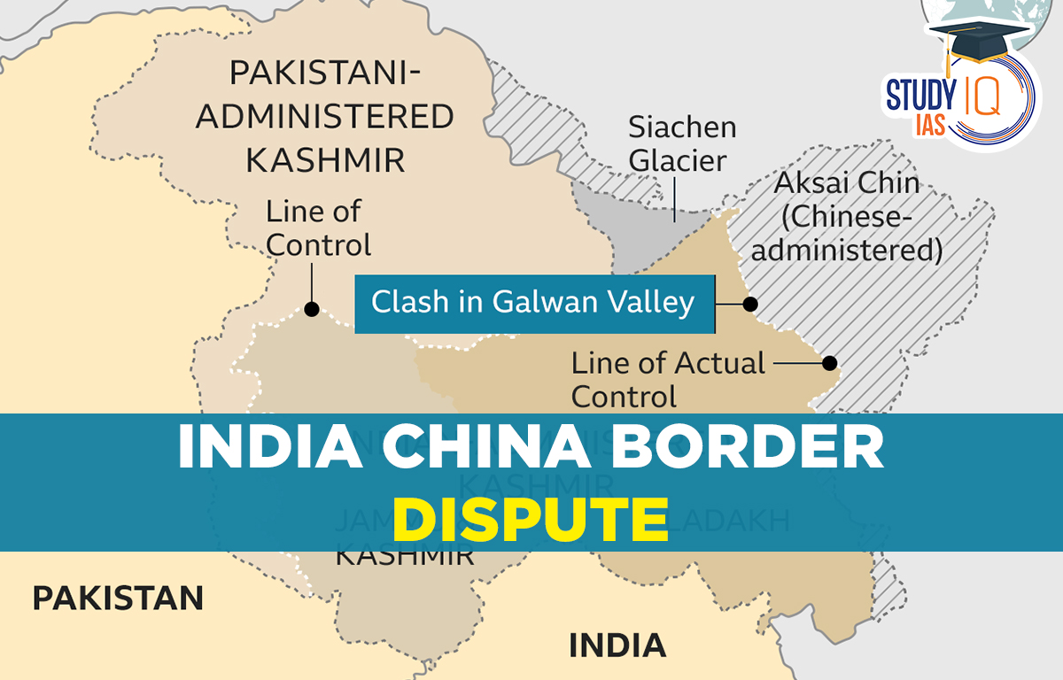
Relations between India and China are worsening as both countries face off along their disputed border in the Himalayas. The main issue is a poorly defined border that stretches 3,440 km (2,100 miles). Natural features like rivers, lakes, and snow caps can shift the boundary, leading to confrontations between soldiers. Also, both nations are competing to build infrastructure along this border, known as the Line of Actual Control. India’s construction of a new road to a high-altitude air base was a key trigger for a deadly clash in 2020.
How serious is the situation?
Despite ongoing military talks, tensions remain high. In December 2022, troops clashed for the first time in over a year near the Tawang sector in Arunachal Pradesh, resulting in minor injuries for some soldiers. Efforts to ease tensions have followed a major clash in June 2020 at Galwan Valley, where soldiers fought with sticks and clubs instead of guns. This was the first deadly confrontation between the two countries since 1975, with at least 20 Indian and four Chinese soldiers losing their lives.
The total boundary shared between India and China is around 3488km (2nd highest after Bangladesh). The border is generally divided into 3 sectors namely
- Eastern,
- Western and
- Middle Sector.
A total of 5 states share boundaries with China, Jammu & Kashmir, Himachal Pradesh, Uttarakhand, Sikkim and Arunachal Pradesh.
Now, India and China pulled back from a border war
India and China have agreed to end a military standoff at their disputed border, four years after a violent clash strained their relationship. While the broader border dispute isn’t resolved, this deal allows both countries to resume patrols in the Ladakh region, helping them reinforce their territorial claims. The announcement came just before Indian Prime Minister Narendra Modi’s trip to the BRICS summit in Russia, where China will also participate. Analysts believe this agreement could improve political and business relations between the two countries and might lead to a meeting between Modi and Chinese President Xi Jinping, their first since 2020.
Indian Foreign Secretary Vikram Misri described the pact as focused on “disengaging” troops at the Line of Actual Control (LAC), which separates Indian and Chinese territories. The LAC stretches 3,488 km (2,167 miles) and represents areas each side controls, rather than their territorial claims. China confirmed the deal but didn’t clarify if it applies to the entire border or just specific conflict areas. Both sides will slightly pull back troops to prevent clashes while establishing a patrol schedule. Regular meetings will help ensure compliance with the agreement.
However, there are still many unanswered questions, such as the status of buffer zones along the LAC that neither side is supposed to patrol.
Read about: India Pakistan Border Dispute
India-China Border Dispute Sector-wise
India-China Border Disputes are broadly divided into three sectors i.e., Western Sector, Middle and Eastern Sector.
Western Sector
India shares a 2,152 km border with China in the western region, which lies between Jammu and Kashmir and Xinjiang. Aksai Chin, a disputed area in this region, has been a point of conflict since colonial times when the borders were not clearly defined.
Johnson Line and McDonald Line were the two borders lines proposed by the Britishers, India considers Johnson’s line (proposed in 1865) which kept Aksai Chin in Jammu Kashmir i.e., under India’s control whereas McDonald Line (proposed in 1893) which placed Aksai Chin under China hence China considers it as the main borderline. At present, LAC is the border line separating Indian areas of Jammu & Kashmir from Aksai Chin which is concurrent to the Chinese-claimed Aksai Chin.
Middle Sector
It is about a 625km long boundary, it is the only sector where both countries have fewer disagreements, and it borders Ladakh and Nepal. The border of Uttarakhand and Himachal Pradesh touches the border of Chinese occupied region of Tibet.
Eastern Sector
It is an 1140 km long boundary with China that extends from eastern Bhutan to the Talu Pass over the Trijunction of Tibet, India and Myanmar. This boundary line is named as McMahon Line. China considers the McMahon line illegal. In Shimla Accord which held in 1914 to settle the boundary dispute between Tibet in India and Tibet and China though the representatives of China did not accept this accord.
Read about: Union Territories
India-China Border Major Disputed Region
Here, we covered all India-China Border Major Disputed Region state-wise in detail.
Himachal Pradesh (Lahaul and Spiti Kinnaur District)
The Kaurik region of Lahaul & Spiti districts is also claimed by China as part of its Tibet province and the Tashigang-Shipki La region of Kinnaur district is also claimed by China as its own part of its Tibet province.
Uttarakhand (Uttarkashi and Chamoli District)
The Sang-Nelang-Pulam Sumda region in the Uttarkashi district of Uttarakhand is also claimed by China as part of its Tibet province. And The plains of Barahoti in the Chamoli district are also claimed by China as part of its Tibet province.
Arunachal Pradesh
The entire state of Arunachal Pradesh is claimed by China as part of its Tibet province. The Chinese government refers to this state as South Tibet. It is worth noting that Taiwan, which India does not recognize as a country and still maintains friendly relations with, also maintains claims over Arunachal Pradesh. Taiwan’s territorial claims are apparently bigger than Chinese territorial claims.
Sikkim (Doklam)
Doklam Valley near the trijunction of India, China and Bhutan, the Chinese attempted to construct a road through the Doklam Plateau region is 100km in size and bounded by Ha Valley of Bhutan, Chumbi Valley of Tibet (China) and the Indian state of Sikkim which being a disputed territory claimed both by China & Bhutan.
Ladakh and Aksai Chin
Aksai Chin is the southwest extension of the Tibet Plateau. The main issue with this region is that the Chinese is making a military road to connect Tibet and Xinjiang region. China got control of this region after the 1962 Sino-Indian War. China considers it part of its Xinjiang province. And Demchok and Chumar sectors of Ladakh as parts of its Tibet province.
India-China Border Dispute UPSC
It appears that while increased economic contacts between Beijing and New Delhi are driven by a desire for tighter cooperation, their bilateral diplomatic interactions are still characterized by competitiveness.
India and China will have had diplomatic relations for 70 years as of April 1st, 2020. It is important for both parties to recognise how precarious the situation is and how the recent events, in particular, have undone years of meticulously negotiated confidence-building measures.
Restoring the border’s original status quo, as it was in April, must be India’s first priority. Both a military show of force at the border, where we must resist Chinese aggression and diplomatic efforts, where we must make it plain to China that its intervention will have serious consequences in all areas of our relationship, are necessary to achieve this.
Even in the digital sphere, India cannot afford to disconnect all of its commercial ties with the second-largest economy in the world. Chinese financing will support India’s emerging economy. However, India can attempt to replace Chinese products with domestic ones in the sectors where it is feasible under the Atmanirbhar Bharat Abhiyan. It also has to strengthen its economic ties with other nations.
 Anti-Defection Law: Origin, Provisions o...
 Central Information Commission (CIC): Ap...
 Panchayati Raj Institutions (PRI): Evolu...