Table of Contents
India Pakistan Border Dispute
Since, 75 years of India’s independence, India has been in boundary disputes with nearly all its neighbors. Over the years leaders of these neighbouring nations have sat together to resolve these boundary disputes. Many of them are already resolved. After the independence India and Pakistan charted out separate courses for nation-building with the hope that there was little left to fight between the two countries. However, the history of India-Pakistan relations over the last 72 years has been a mix of aggression-reconciliation.
- The India-Pakistan conflict began with the 1947 Partition of British India, creating a Muslim-majority Pakistan and a Hindu-majority India. The princely state of Jammu and Kashmir was given the choice to join either country. The maharaja chose to join India for military help against Pakistani invaders, leading to the first Indo-Pakistani War (1947-48). A cease-fire was established in 1949, but tensions continued.
- In 1965, border skirmishes escalated into war, and in 1971, India supported East Pakistan’s independence, forming Bangladesh. The 1972 Simla Agreement aimed for peace but was complicated by both countries developing nuclear weapons.
- In the late 1980s, violence surged in Kashmir, with Pakistan backing militant groups. A brief conflict in 1999, known as the Kargil War, further strained relations. The 2008 Mumbai attacks by militants linked to Pakistan heightened tensions again, but India chose diplomacy over military escalation.
- After several ups and downs in relations, including attempts at peace talks in 2014, tensions spiked again in 2016 with militant attacks. In 2019, India revoked Kashmir’s special status under Article 370, intensifying conflicts and leading to a year-long lockdown in the region.
By 2020, violence increased, but a cease-fire was established in early 2021. The U.S. has tried to mediate but with limited success, while China has become more involved in regional disputes, increasing military ties with Pakistan and posing additional challenges for India.
Read More: India China Border Dispute
Clashes Between India and Pakistan
The War of 1947:
This was the first Kashmir War, starting in October 1947, leading to Jammu and Kashmir’s accession to India. Maharaja Hari Singh faced pressure from tribal forces supported by Pakistan and sought Indian military aid. The conflict went to the UN, resulting in a ceasefire on January 1, 1949, with India controlling two-thirds of the region, while Pakistan gained Gilgit-Baltistan and Azad Kashmir.
The War of 1965:
Triggered by Pakistan’s Operation Gibraltar, this war lasted 17 days as India launched a military response to prevent infiltration into Kashmir. Thousands died, and both superpowers, the USSR and USA, intervened, leading to a ceasefire. India had the upper hand despite Pakistan’s insurgency efforts.
The War of 1971 (Bangladesh Liberation War):
This conflict arose from political tensions in East Pakistan, leading to a war for independence. After India’s intervention following Operation Searchlight, which caused millions of refugees, the Indian army captured significant territory. The war resulted in the creation of Bangladesh and the capture of over 90,000 Pakistani prisoners.
The War of 1999 (Kargil War):
Pakistani troops infiltrated Indian territory in Kargil, leading to military and diplomatic responses from India. Within two months, India regained control of the ridges. International pressure forced Pakistan to withdraw, resulting in heavy casualties for its forces and marking a significant defeat for Pakistan.
Since then, various conflicts have continued, with India adhering to a “no first attack” policy and responding to cross-border terrorism. Diplomatic talks are seen as essential for resolution.
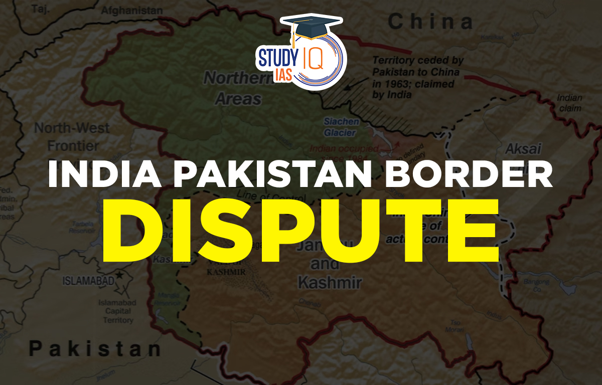
India Pakistan Major Disputed Region
Here is the major India Pakistan Border Dispute described in detail along the border area:
Berubari Region
Radcliffe had divided the district of Jalpaiguri between India and Pakistan by awarding some thanas to one country and others to the other country. The boundary lines were determined based on the boundaries of the thanas and Berubari was one of the Thana.
Berubari was a region in the Cooch Bihar district of West Bengal which was treated as part of India there was some disputed area in this region which was later transferred to East Pakistan (Present Bangladesh) after the Parliament enacted the 9th Constitutional Amendment Act.
Kashmir Region
The dispute over this territory started with the partition of India in 1947. Both India and Pakistan claimed the whole of Jammu & Kashmir (including now the Union territory of Ladakh) till 1963. After 1963, Pakistan recognised Chinese sovereignty over Trans-Karakoram Tract and Aksai Chin. The area of Kashmir, under Pakistan’s occupation, is called Azad Kashmir and Gilgit-Baltistan.
Sir Creek
Sir Creek is a 96 km (60 mi) tidal estuary located in the uninhabited marshlands of the Indus River Delta, forming the border between India and Pakistan. It flows into the Arabian Sea, separating India’s Gujarat state from Pakistan’s Sindh province. The long-standing dispute between India and Pakistan over Sir Creek involves how the border is defined from the creek’s mouth. The boundary is clearly set from a point defined by a 1968 tribunal award.
Read More: India Nepal Border Dispute
Siachen Region
The Karachi ceasefire agreement from July 1949 has some unclear parts that contribute to the Siachen issue. After a certain point south of the Siachen glacier, the agreement just says to go “north to the glaciers” without clear details. In April 1984, during Operation Meghdoot, the Indian Army took control of the highest peaks in the Siachen area to gain the advantage of the high ground. Now, India controls the entire 70 km Siachen Glacier, its tributary glaciers, and three main passes on the Saltoro Ridge: Sia La, Bilafond La, and Gyong La.
Saltoro Ridge Region
It is a range of the Karakoram or Saltoro Ridge. It is located over Karakoram Range the southwest of Siachen. India’s military controlled the peaks and passes of this range in 1984 and Pakistan controls the western part of the valley.
In 2020, Pakistan released a new political map that included the former princely states of Junagadh and Manavadar.
India Pakistan Border Dispute Way Forward
A light of hope is offered by occasions like the opening of the Kartarpur Corridor, where political issues are put on the back burner and widespread feeling is prioritized on both sides, despite the bilateral ties being at an all-time low.
The only way out now, when the Indian government maintains that talks and terrorism cannot coexist, appears to be through non-political measures, such as trade concessions, people-to-people confidence-building measures, and international mediation. Pakistan’s political policy with India is complete isolation, disruption of bilateral and diplomatic talks, and complete isolation of India.
Normalcy in Kashmir
India should focus on bringing Jammu & Kashmir back to normal by integrating the population, particularly the young, and promoting regional investment. By addressing matters like the NRC with knowledge and calming minority concerns in India, CAA would disarm Pakistan in international forums.
Trade Facilitation
Pakistan is in a grave economic situation and is about to face further international sanctions (FATF grey list). At this point, lowering trade barriers on a bilateral basis and facilitating cross-border trade could help bridge the trust gap between the two nations.
International Mediation
The necessary momentum for peace might come from countries like the US, China, and Russia, which have suggested bilateral talks after the revocation of Resolution 370. Annual meetings of groups like the SCO and SAARC could also help start positive discussions. India should wait for Pakistan to stabilize before seeking quick solutions for peace. While Pakistan’s internal politics are beyond India’s control, it shouldn’t dictate the terms of their relationship. India should focus on containment and negotiation. The best outcome would be restoring diplomatic ties, resuming trade, and easing some travel restrictions.
 Anti-Defection Law: Origin, Provisions o...
 Central Information Commission (CIC): Ap...
 Panchayati Raj Institutions (PRI): Evolu...