Table of Contents
Context: A multinational research expedition led by Germany’s GEOMAR centre has been launched to map and neutralise 1.6 million tonnes of corroding World War II munitions that are leaking carcinogenic toxins into the Baltic Sea’s ecosystem.
Baltic Sea
The Baltic Sea is a semi-enclosed in Northern Europe, part of the North Atlantic Ocean. It stretches from southern Denmark to near the Arctic Circle, separating the Scandinavian Peninsula from continental Europe. It has about 8000 km of coastline, shared by countries like Sweden, Poland, and Finland. The sea covers roughly 377000 sq km, is about 1600 km long, and 193 km wide. It connects to the White Sea via the White Sea Canal and to the North Sea through the Kiel Canal, linking to the Atlantic Ocean through the Danish Straits.
The Baltic Sea has three major gulfs: the Gulf of Bothnia, the Gulf of Finland, and the Gulf of Riga. It is the world’s largest brackish inland water body with lower salinity than the oceans due to fresh water from rivers and its shallow depth. More than 250 rivers flow into the Baltic Sea, with the Neva being the largest. The sea has over 20 islands, with Gotland being the largest.
Facts About Baltic Sea
- Location: Situated in Northern Europe, it is an arm of the Atlantic Ocean, connected to it via the North Sea.
- It is often described as the world’s largest expanse of brackish water.
- Bordering Countries: Sweden, Finland, Russia, Estonia, Latvia, Lithuania, Poland, Germany, and Denmark.
- Connections: It connects to the North Sea through the Kiel Canal (man-made) and the Danish Straits (Oresund, Great Belt, and Little Belt) via the Kattegat and Skagerrak straits.
- Major Rivers draining into the Baltic Sea: Vistula, Oder, Neva, Daugava, and Niemen.
- Major Straits and canals: The Sound, Great Belt, Little Belt, Fehmarn Belt, Kadetrinne, Kattegat, Skagerrak
- Major Ports: Petersburg (Russia), Stockholm (Sweden), Copenhagen (Denmark), Gdańsk (Poland), and Helsinki (Finland).
- Often referred to as a “NATO Lake” since Finland and Sweden joined the alliance, leaving Russia as the only non-NATO littoral state.
Environmental Concerns in Baltic Sea
- WWII Munitions Leakage: Approximately 6 million tonnes of rusting conventional and chemical weapons are leaking carcinogenic toxins (like TNT) and heavy metals into the seafloor.
- Eutrophication: Excessive nutrient runoff (nitrogen and phosphorus) from intensive agriculture in bordering countries leads to massive algal blooms and oxygen depletion.
- Dead Zones: Due to its shallow, semi-enclosed nature and low water exchange, large areas of the seabed are hypoxic (oxygen-poor).
- Microplastics & Shipping: High traffic in the Danish Straits and Kiel Canal increases the risk of oil spills, invasive species from ballast water, and significant plastic pollution.
Read More: Arabian Sea
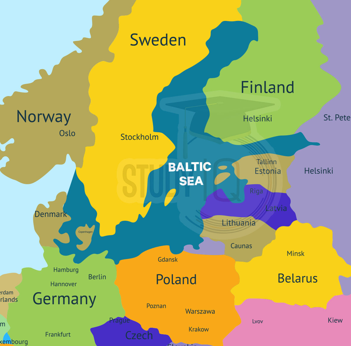
Baltic Sea in World Map
The Baltic Sea is known for its proximity to many countries, brackish water, and seasonality. Here is the map of the Baltic Sea.
Read More: Sea of Azov
Bordering Countries and Geographic Location of Baltic Sea
The Baltic Sea extends into the Atlantic Ocean. The Baltic sea is surrounded by:
- Denmark,
- Estonia,
- Finland,
- Germany,
- Latvia,
- Lithuania,
- Poland,
- Russia,
- Sweden, and
- the North and Central European Plain.
Read More: Sea of Japan
Physical Features of Baltic Sea
The latitude of the Baltic sea is 53°N to 66°N, and its longitude is 10°E to 30°E.
- The Scandinavian ice sheet melted towards the Arctic at the end of the Pleistocene Epoch, creating the Baltic Sea.
- Around 14,000 years ago, northern Europe was covered in ice, reaching the current German-Polish border.
- By 7700 BC, melting ice formed the Yoldia Sea, stretching from the Skagerrak across southern Sweden to Lake Ladoga.
- A thousand years later, Ancylus Lake, a freshwater lake, existed from Arctic Sweden and Finland to the southern Baltic.
- The deepest part of the Baltic Sea is Landsort Deep off the southeast coast of Sweden, at 1,506 feet (459 meters).
- Other deep areas include Gotland Deep (817 feet or 249 meters) and a deepwater channel in the Gulf of Finland.
- The Baltic Sea borders several countries, including the Baltic nations to the west and north, and Russia to the east.
- Belarus is to the southeast, and Poland and a Russian exclave are to the southwest of the Baltic Sea.
Read about: Indian Ocean Dipole
Baltic Sea Climate
The Baltic climate is marked by distinct seasons, with long, cold winters and short, warm summers.
- Average winter temperatures can be around 14 °F (−10 °C) in the northern parts, while midsummer temperatures can reach about 63 °F (17 °C) in the south.
- The climate can vary, influenced by mild maritime weather from the North Atlantic or cold continental conditions, leading to extremes in winter and summer.
- Precipitation averages between 20 to 24 inches (500 to 600 mm) per year, with cloudy weather being common and fog occurring mostly in spring and early summer.
- Winds are usually mild and variable, with sea breezes often seen in coastal areas during the summer.
Read about: Indian Ocean
Baltic Sea Significance
The Baltic Sea, which connected various regions of Europe, served as the economic hub of the Hanseatic League, a federation of trading cities that existed from the thirteenth to the seventeenth centuries. Poland, Sweden, and Denmark competed with one another for control of the Baltic Sea in the late 16th and early 17th centuries.
The Baltic Sea is important to many people. It is located in northern Europe and is surrounded by nine countries, including Poland, Germany, Sweden, Lithuania, Latvia, Finland, and Estonia. It is also significant because it connects to the North Atlantic Ocean. The sea stretches northward, separating the Scandinavian Peninsula from the rest of Europe.
Read More: Mediterranean Sea
 Persian Gulf: Location, Importance and G...
 Erratic Weather in March, Causes and Imp...
 Punjab–Rajasthan River Dispute: Ravi�...