Table of Contents
The Arabian Sea is a prominent body of water located in the northwestern part of the Indian Ocean. It plays a crucial role in international trade, geopolitics, and the marine ecosystem. This article delves into the Arabian Sea’s map, location, surrounding countries, and its overall significance.
Arabian Sea
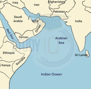
The Arabian Sea is an area of the northern Indian Ocean bounded on the north by Pakistan, Iran, and the Gulf of Oman, on the west by the Gulf of Aden, the Guardafui Channel, and the Arabian Peninsula, on the southeast by the Laccadive Sea, the Somali Sea, and on the east by India. The Gulf of Aden connects the Arabian Sea to the Red Sea via the Bab-el-Mandeb strait in the west, while the Gulf of Oman connects the Arabian Sea to the Persian Gulf in the northwest.
Read More: Atlantic Ocean
Arabian Sea in India Map
The Arabian Sea is bordered by several key regions and countries. To the west, it is flanked by the Arabian Peninsula, while the eastern boundary includes the Indian subcontinent. The northern part is bordered by Pakistan and Iran, with the southern boundary merging into the Indian Ocean.
Geographical Coordinates
- Latitude: 12°N to 25°N
- Longitude: 51°E to 77°E
Major Water Bodies Connected
- Persian Gulf: Via the Strait of Hormuz
- Gulf of Oman: Connecting to the Persian Gulf
- Indian Ocean: Towards the south
- Red Sea: Via the Bab-el-Mandeb Strait and the Gulf of Aden
Where is the Arabian Sea Located
The Arabian Sea is a region of the northwestern part of the Indian Ocean, situated between the Arabian Peninsula (to the west) and the Indian subcontinent (to the east). It is a body of water that connects the Red Sea to the northwest with the Gulf of Oman to the southeast.
Arabian Sea Countries
The Arabian Sea is bordered by several countries namely Yemen, Oman, Pakistan, Iran, India, and the Maldives. All have coastlines on the Arabian Sea. It is an arm of the Indian Ocean and is located between the Arabian Peninsula and the Indian Subcontinent.
Read about: Pacific Ocean
Arabian Sea Islands
The most important islands in the Arabian Sea are the Lakshadweep Islands (India), Socotra (Yemen), Masirah (Oman), and Astola Island (Pakistan).
The Lakshadweep Islands (formerly known as the Laccadive, Minicoy, and Aminidivi Islands) are a group of islands in the Arabian Sea’s Laccadive Sea region, 200 to 440 km (120 to 270 mi) off India’s southwestern coast. The archipelago is a union territory governed by India’s Union Government. The islands are India’s smallest union territory, with a total surface area of only 32 km2 (12 sq mi). The Maldives islands are located nearby. These islands are all part of the Lakshadweep-Maldives-Chagos island group.
Zalzala Koh was a new island that had only been around for a few years. The mud island formed as a result of the 2013 earthquake in Pakistan. The island was completed in 2016.
Read More: South China Sea
Arabian Sea Geography
The Arabian Sea has a surface area of approximately 3,862,000 km2 (1,491,130 sq mi). The sea’s maximum width is about 2,400 km (1,490 mi), and its maximum depth is 4,652 meters (15,262 ft). The Indus River is the largest river that flows into the Arabian Sea. The Arabian Sea has two major branches:
- The Gulf of Aden is in the southwest, which connects with the Red Sea via the Bab-el-Mandeb Strait, and
- The Gulf of Oman is in the northwest, which connects with the Persian Gulf.
On the Indian coast, there are also the Gulfs of Khambhat and Kutch. It has a maximum depth of about 5,450 meters and is known for its high salinity and monsoon winds.
Read about: Indian Ocean Dipole
Arabian Sea Significance
Since as early as the third millennium BCE, the Arabian Sea has served as a crucial marine trade route, especially during the Age of Sail. It connects the Indian Ocean with the Persian Gulf, playing a key role in global shipping and commerce. The sea is rich in oil and natural gas, making it a significant energy source for the region.
Strategically located, the Arabian Sea is home to major ports and naval bases from countries like India, Iran, and the United States, ensuring its importance for regional security. Additionally, it acts as a major transit hub between Asia, the Middle East, and Africa, and supports local economies through its abundant seafood resources.
Read More: East China Sea
Arabian Sea UPSC
With its strategic location concerning the Red Sea (including the Suez Canal) and the Persian Gulf, the Arabian Sea contains some of the world’s busiest shipping lanes, and the main routes originate in those two extensions. In this article, you will get to know about the details of the Arabian sea that would be useful for the UPSC exam.
 Sex Ratio in India 2026: Latest Trends, ...
 Civil Disobedience Movement (CDM): Cause...
 Role of Teachers in Educations, Student ...