Table of Contents
Context: The GSLV-F15 NVS-02 mission marks ISRO’s 100th launch from Sriharikota, deploying a 2nd-generation NavIC Satellite equipped with advanced atomic clocks and L1 frequency for enhanced regional navigation.
What are Navigational Systems?
- Navigational Systems are satellite constellations that broadcast positioning, navigation and timing data over a region or completely across the globe.
- The majority of these constellations make use of radio frequencies in the L-Band to transmit their signals to the receiver on the ground.
What is NavIC Navigation System?
- About: The Indian Regional Navigation Satellite System (IRNSS), with an operational name of NavIC, is an independent stand-alone navigation satellite system developed by the ISRO.
- Timeline: NavIC was originally approved in 2006. It was expected to be completed by late 2011 but only became operational in 2018.
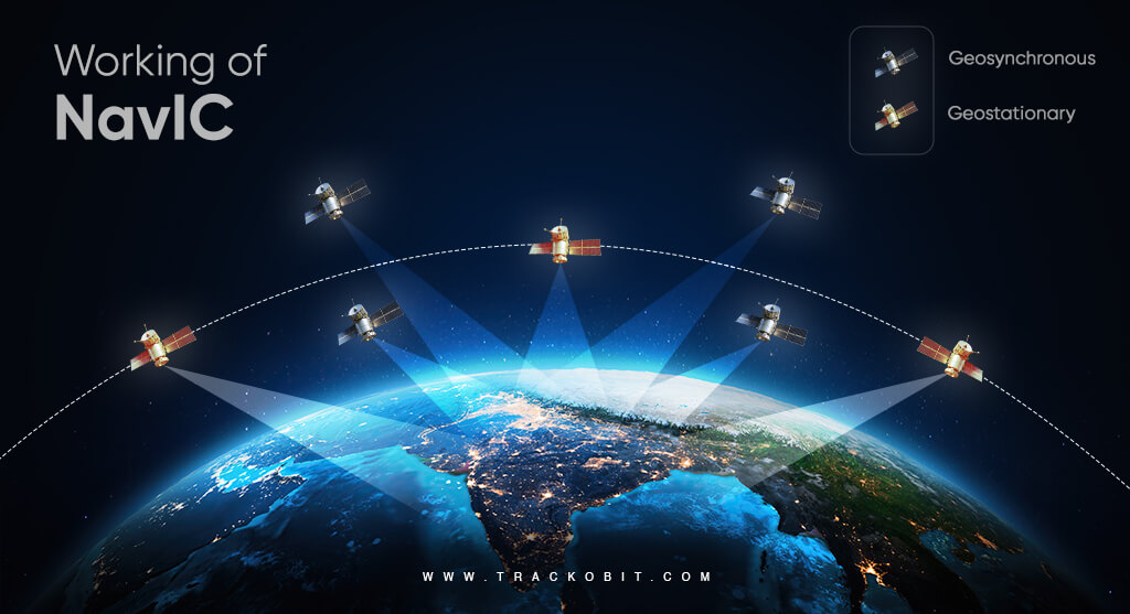
- Constellation: It consists of a constellation of 8 satellites located at a distance of approximately 36,000 Km. Currently, 7 satellites are active.
- 7 satellites initially launched between 2013-2018.
- Designed for a 10-year mission life, but some satellites needed early replacement due to issues with onboard atomic clocks.
| Atomic Clock |
|
Coverage
- Primary service area: This region extends up to 1500 km from the boundaries of the Indian landmass. In this region, it provides accurate position information service accuracy of better than 20 m.
- Extended Service Area: Lies between the primary service area and the area enclosed by the rectangle from Latitude 30° S to 50° N, Longitude 30° E to 130° E.
Services
IRNSS will provide two types of services:
- Standard Positioning Service (SPS): This is provided to all the users.
- Restricted Service (RS): this is an encrypted service and much more accurate (in the range of 1 to 5 meters), and meant for defence applications and use by armed forces.
Second-Generation Satellites
- A total of 5 satellites (NVS-01 to NVS-05) are planned to augment the base layer.
- NVS-01 was launched in May 2023.
- NVS-02 is now being launched to improve accuracy and reliability.
- New satellites are equipped with L1 frequency, widening usability to smaller devices like smartphones and fitness trackers.
Applications of NavIC
Civil Applications
- Positioning through mobile phones: Many Smartphone chipsets have integrated NavIC receivers, which can effectively replace the existing GPS for positioning services.
- Logistics sector: NavIC would revolutionize the logistics sector in India as it would help with better optimization and route suggestions. Route optimization will reduce cost and also pollution.
- Promote startups: There is ample scope for startups to emerge by keeping navigation services at the core of their business. This will also reduce costs for companies that utilize the navigational services of GPS.
- Fleet tracking: Fleet tracking is very useful during mining and transport operations to reduce costs and optimize resources.
- Navigation services: NavIC can provide navigational services to aerial, marine and terrestrial transports due to its better accuracy.
Military Applications
- Enemy positions: A domestic navigational system such as NavIC will help India track enemy positions during war.
- Border security: The borders of the country can be kept under vigilance using an indigenous tracking system. It will prevent surprise attacks by enemies.
- Weapon tracking: Navigational systems can also be used to track fired weapons and also current position of our military assets.
- Drone technology: Drones can be controlled and tracked using such navigational satellites, improving their military capabilities tremendously.
Features of NavIC
- Higher accuracy: NavIC open signals have an accuracy of up to 5 metres and restricted signals will be even more accurate. GPS by comparison is accurate up to around 20 metres.
- Timing Accuracy: Better than 40 nanoseconds.
- Range: The NavIC navigational system provides coverage over the Indian landmass and up to a radius of 1,500 km around it.
- Can work in hard-to-reach areas: In its range area, NavIC signals will be available in even hard-to-reach areas.
- Geo-stationary orbit: NavIC uses satellites placed in high geo-stationery orbit, allowing them to move at a constant speed relative to Earth so that they can look over the same region on Earth.
- Optimal signal receiving: NavIC signals in India are received at a 90-degree angle, making it easier for them to reach devices located even in congested areas, dense forests, or mountains.
- Current usage: Currently, NavIC’s use is limited. It is being used in public vehicle tracking in India, for providing emergency warning alerts to fishermen venturing into the deep sea where there is no terrestrial network connectivity, and for tracking and providing information related to natural disasters.

Comparison of NavIC with Other Global Navigation Systems
NavIC v/s GPS
- Coverage: GPS caters to users across the globe and its satellites circle the earth twice a day, while NavIC is currently for use in India and adjacent areas.
- Satellite constellation: GPS requires 24 Satellites to be operational and has around 31 satellites in orbit. All of these are Geosynchronous Satellites. On the other hand, NavIC has 3 Geostationary satellites and 4 geosynchronous satellites, and these satellites are situated in much higher orbit (signal is less prone to obstructions).
- Accuracy: NavIC satellites use dual frequency bands (L5-band and S-band), which is why the system is relatively more accurate than GPS (which uses a single band and compensation for error due to signal deterioration by the atmosphere).
- Interoperability: NAVIC’s interoperability with GPS can ensure the minimization of technical snags when used in complementarity with existing GPS-enabled solutions.
Other Navigation Systems
- Global Positioning System (GPS): GPS is operated by the U.S. Space Force. Its first satellite was launched in 1978, and its first series of satellites became fully operational by 1993.GPS consists of 31 satellites.
- GLONASS: Russian-owned GLONASS is operated by Roscosmos State Corporation for Space Activities, a department of the Russian government.
- It was launched fully in 1995, with full satellite coverage over Russia in 2010. The constellation consists of 24 satellites.
- Galileo: Owned by the European Global Navigation Satellite Systems Agency, Galileo consists of 26 satellites in orbit, with a plan to reach 30 satellites by 2021.
- BeiDou: Launched first in 2000, BeiDou is owned by China National Space Administration (CNSA). Currently, it has 48 satellites in the orbit.
- QZSS: Launched first in 2010, the Quasi-Zenith Satellite System (QZSS) is operated by the Japan Aerospace Exploration Agency (JAXA).
- It does not provide global coverage but instead maintains Asia-Oceana regional coverage between Japan and Australia.

Significance of NavIC for India
- Strategic significance: It will help to reduce dependence on foreign satellite systems for navigation services, particularly for strategic sectors. It will make the Indian Armed Forces self-reliant.
- Neighbourhood relations: With the provision of extended coverage, one of the stated future uses of the project includes sharing the project with the SAARC nations. This will help in integrating the regional navigation system further and strengthening our “Neighbourhood First” policy.
- Net security provider: Having a global navigation system bolsters the ability of a nation to serve as a net security provider.
- E.g. GPS played a significant role in relief efforts post disasters such as the tsunami in the Indian Ocean region in 2004 and the Pakistan-India earthquake in 2005, and has delivered significant strategic and economic benefits to the US.
- Food and livelihood security: Through land-area mapping, yield monitoring and precision-planting of crops, NAVIC allows for the development of civic capabilities in food and livelihood security.
- Scientific advancement: In addition to its civilian and military applications, it will contribute to the advancement of science and technology.
Challenges Faced by NavIC
- Malfunctions in Atomic Clocks: Replacement of satellites became necessary before the end of their mission life.
- Failure of IRNSS-1H Launch: Heat shield malfunction during launch prevented deployment.
- Underutilization:
- A 2018 CAG Report highlighted delays in the development of user receivers.
- Work on receivers began only in 2017, despite funding approval in 2006.
- Wasted years of satellite mission life due to delays.
| UPSC PYQ |
| Q. Which one of the following countries has its own Satellite Navigation System? (2023)
(a) Australia (b) Canada (c) Israel (d) Japan Answer: D |
 Artificial Intelligence in Diplomacy: Ap...
 Google AI Data Centre in Visakhapatnam: ...
 Drone Warfare: Strategic Shift in Modern...