Table of Contents
The NHAI set up in 1988 works under the Ministry of Road Transport and Highways (MoRTH). NHAI is mainly responsible for the development and maintenance of National Highways. Over the years, NHAI has been important in improving road connectivity in India and boosting economic growth. National highways are very important for India. They connect big cities, towns, and industrial areas, helping to build the country’s infrastructure. These highways are important for moving goods and people, they also cut down travel time making it easier to get medical help and handle emergencies quickly. Moreover, they bring communities closer together, improving social connections. For national security, highways are major support as they help in moving military forces.
Read about: National Parks in India
National Highway List
Here is the complete List of National Highways in India given below:
| Old National Highway Number | New National Highway Number | Serial No. in NH Act, 1956 | States/UTs Through which it Passes |
| NH 1 A and NH 1 D | NH 1 | 1 | Jammu & Kashmir |
| NH 1 B | NH 244 | 144 | Jammu & Kashmir |
| NH 2 | NH 19 (Golden Quadrilateral) | 63 | Bihar, Delhi, Haryana, Jharkhand, Uttar Pradesh, West Bengal |
| NH 2A | NH 519 | 66 | Uttar Pradesh |
| NH 2B | NH 114 | 40 | West Bengal |
| NH 3
NH 50 |
NH 60 | 188 | Maharashtra |
| NH 223 | NH 4 | 12 | Andaman & Nicobar Islands |
| NH 4 A | NH 748 | 165 | Goa, Karnataka |
| NH 4 B | NH 348 | 161 | Maharashtra |
| NH 5
NH 6 NH 60 NH 217 |
NH 16 (Golden Quadrilateral) | 49 | Andhra Pradesh, Odisha, Tamil Nadu, West Bengal |
| NH 7 | NH 135 | 123 | Madhya Pradesh, Uttar Pradesh |
| NH 7 A | NH 138 | 131 | Tamil Nadu |
| NH 8 | NH 48 (Golden Quadrilateral) | 157 | Delhi, Gujarat, Haryana, Karnataka, Maharashtra, Rajasthan, Tamil Nadu |
| NH 8 A | NH 41 | 139 | Gujarat |
| NH 8 C | NH 147 | 154 | Gujarat |
| NH 8 D | NH 151 | 171 | Gujarat |
| NH 9 | NH 65 | 196 | Andhra Pradesh, Maharashtra, Karnataka, Telangana |
| NH 11 | NH 21 | 73 | Rajasthan, Uttar Pradesh |
| NH 11 A | NH 148 | 158 | Rajasthan |
| NH 12 | NH 45 | 336 | Madhya Pradesh, Chattisgarh |
| NH 18
NH 4 |
NH 40 | 136 | Andhra Pradesh, Tamil Nadu |
| NH 21
NH 22 NH 95 |
NH 5 | 13 | Haryana, Chandigarh, Himachal Pradesh, Punjab |
| NH 23 | NH 320 | 71 | Jharkhand |
| NH 24 | NH 530 | 102 | Uttar Pradesh |
| NH 30 | NH 319 | 65 | Bihar |
| NH 35 | NH 112 | 37 | West Bengal |
| NH 39 | NH 129 | 98 | Assam, Nagaland |
| NH 47 | NH 544 | 147 | Kerala, Tamil Nadu |
| NH 47 A | NH 966 B | 205 | Kerala |
| NH 47 C | NH 966 A | 204 | Kerala |
| NH 55 | NH 110 | 34 | West Bengal |
| NH 56 | NH 731 | 110 | Uttar Pradesh |
| NH 79 | NH 156 | 184 | Rajasthan |
| NH 152 | NH 127 A | 87 | Assam |
| NH 38 & NH 153 | NH 315 | 45 | Assam, Arunachal Pradesh |
Read about: World Heritage Sites in India
State-Wise National Highways Length
| State | Length of National Highways (Kms) |
| Andhra Pradesh | 6529.5 |
| Arunachal Pradesh | 2537.4 |
| Assam | 3908.5 |
| Bihar | 5030.6 |
| Chattisgarh | 3605.8 |
| Goa | 292.9 |
| Gujarat | 6635 |
| Haryana | 3097.6 |
| Himachal Pradesh | 2606.9 |
| Jharkhand | 3366.8 |
| Karnataka | 7334.8 |
| Kerala | 1781.6 |
| Madhya Pradesh | 8772.3 |
| Maharashtra | 17756.6 |
| Manipur | 1750.3 |
| Meghalaya | 1155.6 |
| Mizoram | 1422.5 |
| Nagaland | 1547.7 |
| Odisha | 5761.5 |
| Punjab | 3769.5 |
| Rajasthan | 9988.8 |
| Sikkim | 463 |
| Tami Nadu | 6741.5 |
| Telangana | 3795.5 |
| Tripura | 853.8 |
| Uttar Pradesh | 11736.8 |
| Uttarakhand | 2949.3 |
| West Bengal | 3664.5 |
Longest National Highway in India
NH 44 (formerly NH7) is the longest national highway in India of length 3745 Km, running from Jammu and Kashmir to Kanyakumari, passing through states like Himachal Pradesh, Punjab, Haryana, Delhi, Uttar Pradesh, Madhya Pradesh, Maharashtra, Telangana, Andhra Pradesh, Karnataka, and Tamil Nadu. 7 National highway merged in National highway 44.
Shortest national highway in India
NH- 548 and NH- 118, both are India’s shortest National highways, each have length 5Km,
- NH- 548 located in Maharastra
- NH-118 is located in Jharkhand
National Highways Important Facts
- The Golden Quadrilateral is a network of national highways connecting Delhi, Kolkata, Mumbai, and Chennai, the major cities in India. India has the second-largest road network in the world, with national highways making up 40% of it.
- The Leh-Manali highway connects Shimla to Leh in Ladakh and is the second-highest motorable highway in the world. NH 48 (formerly NH8) is the longest national highway within a single state, running all the way through Gujarat from the Rajasthan border to the Maharashtra border.
- The North-South Corridor (NH 7, NH 44, NH 16) is the longest national highway corridor in India, stretching over 4,000 km from Srinagar in Jammu and Kashmir to Kanyakumari in Tamil Nadu. The East-West Corridor (NH 27, NH 30, NH 31, NH 31C, NH 12, NH 16) is the second-longest, running about 3,700 km from Porbandar in Gujarat to Silchar in Assam.
- NH 52 goes through the northeastern states of Assam, Meghalaya, and Mizoram and is the only national highway that passes through a wildlife sanctuary (Nokrek National Park).
- The longest road tunnel in India is the Chenani-Nashri Tunnel, which is 9.2 km long and located on NH 44 in Jammu and Kashmir. The Bandra-Worli Sea Link is a toll bridge that connects Bandra in Mumbai to Worli across Mahim Bay and is part of NH 48.
- NH 66 runs along the west coast of India from Panvel in Maharashtra to Kanyakumari in Tamil Nadu. It was previously known as NH 17 and is the only national highway in India that passes through four states: Maharashtra, Goa, Karnataka, and Kerala.
Read about: States and Capitals of India
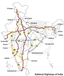
National Highways Map
The national highways of India form a vast network connecting major cities, towns, and rural areas across the country. The map displays the extensive road system that plays a crucial role in facilitating trade, commerce, and travel.
Read about: Wildlife Sanctuaries of India
National Highways Authority of India
The National Highways Authority of India (NHAI) is an autonomous agency responsible for the development, management, and maintenance of India’s national highways. It was established in 1988 and operates under the Ministry of Road Transport and Highways. NHAI is responsible for the construction of new highways, upgrading and expansion of existing highways, toll collection, and monitoring the overall safety and efficiency of the national highway network.
| National Highway Authority of India |
|
Read about: National Symbols of India
National Highways in India UPSC
National Highways in India is an important topic for the UPSC (Union Public Service Commission) exam. The exam covers a wide range of topics, including the infrastructure of the country, which includes the national highway network. Candidates need to have a thorough understanding of the national highways in India and their significance in the country’s economy and development.
Read about: Union Territories
 TNPSC Group 2 Mains Result 2026 PDF, Sco...
 Best UPSC Mains Booklist 2026: Subject-w...
 UPPSC Notification 2026 Out, Apply Onlin...