Table of Contents
Context: Implementation of recommendations of Kasturirangan Committee by Karnataka
More in News
- The Union government reissued the draft notification classifying parts of the Western Ghats in six States, including Karnataka, as ecologically sensitive areas (ESAs).
- Karnataka Forest and Environment Minister said the decision on the implementation of the Kasturirangan Committee report would be taken only after discussing the issue in the State Cabinet and with leaders of all political parties of the State.
Recommendations of Kasturirangan Committee (2013) on Western Ghats
- It sought to balance development and environmental protection in contrast to the system proposed by the Gadgil report.
- It distinguished between cultural and natural landscapes in the region.
- It has recommended a prohibition on development activities in a 60,000 sq. km ecologically sensitive area spread over Gujarat, Karnataka, Maharashtra, Goa, Kerala and Tamil Nadu.
- Out of this, 20,668 sq km of the area falls in Karnataka covering 1,576 villages.
- It recommended that instead of the total area of Western Ghats, only 37% of the total area should be brought under ESA and a complete ban on mining, quarrying and sand mining be imposed in ESA.
This article provides a wealth of crucial information on the Western Ghats. Western Ghats is an important part of Geography, an important subject in the UPSC Syllabus. Students can also go for the UPSC Mock Test to get more accuracy in their preparations.
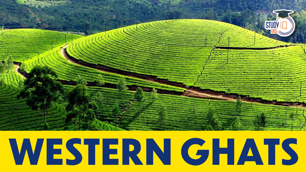
About Western Ghats
A mountain range known as the Western Ghats runs parallel along India’s western coast from Gujarat to Tamil Nadu, passing through the states of Maharashtra, Goa, Karnataka, and Kerala. The Ghats are also a UNESCO World Heritage site and are frequently referred to as the Great Escarpment of India.
The Western Ghats were created by the Arabian basin being subducted and the peninsula being tilted east and northeast during the Himalayan uplift. Because of the escarpments and staircase formations on the hill, it appears as though mountains towards the west are blocked. The Western Ghats, which encompass six states including Gujarat, Maharashtra, Goa, Karnataka, Tamil Nadu, and Kerala, is one of the world’s eight biodiversity hotspots.
It has been given the UNESCO World Heritage designation. One of the eight “hottest hotspots” for biological diversity in the globe. According to UNESCO, the Western Ghats are older than the Himalayas. By blocking rain-filled monsoon winds that arrive from the southwest in the late summer, they have an impact on the weather patterns associated with the Indian monsoon. It extends all the way from Kanyakumari to Tapi Valley. Up to 11° N, it is referred to as Sahyadri. It is separated into three parts:
- Northern Western Ghats
- Middle Sahyadri(Central Western Ghats)
- Southern Western Ghats
Northern Western Ghats
In the region between Tapi Valley and 16° N latitude lie the Northern Western Ghats. It has basaltic lava all over it. The highest point is Kalsubai. Mountains are cut through by rivers. Horizontal sheets of Deccan lavas (Deccan Traps) make up the northern Ghats, which extend from Tapi Valley to a bit to the north of Goa. This section of the Ghats has an average elevation of 1,200 metres above mean sea level, however, some peaks have higher elevations.
Kalasubai (1,646 m), Salher (1,567 m), which is located around 90 km north of Nashik, Mahabaleshwar (1,438 m), and Harishchandragad (1,424 m) are significant peaks. The Konkan Plains in the west and the Deccan Plateau in the east are connected by road and rail through the crucial passes of Thal ghat and Bhor ghat.
Middle Sahyadri (Central Western Ghats)
The Nilgiri hills are located in the Middle Sahyadri range, which extends from latitude 16°N. Gneisses and granites make up this part. There is a lot of woodland in the area. The western scarp has been extensively shattered by headward erosion caused by westward moving streams. Although many peaks reach 1500 metres, the average height is 1200 metres.
The Vavul Mala (2,339 m), Kudremukh (1,892 m), and Pashpagiri (1,714 m) are significant peaks. Around the triangular intersection of Karnataka, Kerala, and Tamil Nadu, the Nilgiri Hills rise abruptly to heights of more than 2,000 metres and link to the Sahyadris. They serve as the juncture where the Western and Eastern Ghats converge. The two highest peaks in this region are Makurti (2,554 m) and Doda Betta (2,637 m).
It is in the Central Western Ghats and has a granitic structure. Karnataka’s tallest peak, Mullayanagiri, is located on Baba Budan Hill. Along with waterfalls like Gersoppa/jog Falls across the Sharavathi River, this area has developed nick sites. This area is marked by two distinct characteristics: the Malnad hills and the Maidan plateaus. Talakaveri Lake is a body of water fed by the River Kaveri, which originates in the Brahmagiri Hills.
Southern Western Ghats
The main Sahyadri range and the southern portion of the Western Ghats are divided by Pal ghat Gap. A different name for it is the southern mountain complex. The high mountains abruptly come to a stop on each side of this gap. Pal Ghat Gap is a rift valley. The lowlands of Tamil Nadu and the coastal plains of Kerala are connected by a multitude of motorways and railway lines that take advantage of this gap. Through this opening, moist-bearing clouds from the southwest monsoon can travel some distance inland and provide rain to the Mysore region.
There is a complicated network of steep, uneven slopes on both the eastern and western sides of the Ghats south of the Pal ghat Gap. Southern India’s highest point is Anai Mudi (2,695 m). Three mountains that radiate in opposing directions surround Anai Mudi. To the north, the Palani (900-1,200 m) range, to the northeast, and to the south, the Cardamom Hills or Maalaimalar range may be found.
The Nilgiris, Annamalai, and Cardamon ranges, as well as the Palani Palghat gap, which is situated between the southern half of the Western Ghats and the main Sahyadri range, are the three parallel ranges to the coast that make up the southern Western Ghats. The elevation of these mountains varies from 1600 to 2500 metres. The tallest peak in Nilgiris is Doddabetta. The highest peak in South India and Annamalai is Anamudi. Agasti Malai is the highest point in the Cardamom Hills.
| About Eco-Sensitive Zones (ESZ) |
|
Western Ghats Geography and Climate
The Western Ghats is a mountain range that stretches from Gujarat in the north to the southernmost point of the Indian subcontinent. It runs parallel to the western coast of India. The Anaimalai Hills, Nilgiri Hills, and Cardamom Hills are only a few of the minor ranges that make up this Sahyadri mountain range.
The monsoon season in India is brought on by the Western Ghats, which are renowned for their heavy rainfall. The area experiences 2,500 to 3,000 mm of yearly rainfall. In the Western Ghats, the monsoon season starts in June and lasts through September. The tropical climate of the area is distinguished by hot, humid summers and moderate winters.
Western Ghats Biodiversity
The Western Ghats is one of the top biodiversity hotspots in the world, home to a broad range of plant and animal species. In addition to 6,000 insect species, the range is home to 139 animal species, 508 bird species, 179 amphibian species, and over 5,000 kinds of flowering plants. The Nilgiri tahr, Lion-tailed macaque, and Malabar giant squirrel are among the endangered species that call the Western Ghats home.
In addition, the Western Ghats are the only place on earth where a number of endemic species can be found. More than 325 endemic plant species and 160 endemic animal species can be found in the range. Due to its isolation from neighbouring mountain ranges and distinctive topography, which has produced a variety of microhabitats, the area has a high level of endemism.
Western Ghats Importance and Threats
The Western Ghats are crucial to the ecology of the area because they provide crucial ecosystem services like soil conservation, carbon sequestration, and water provision. Millions of people who live in the area depend on the range for their livelihood and use the forests for medicinal herbs, fuelwood, and timber.
Despite its significance, the Western Ghats is threatened by a number of factors, including habitat degradation, deforestation, and fragmentation. Additionally, the region is under more pressure from human endeavours including infrastructure development, mining, and agriculture. The biodiversity of the area is also under threat from climate change, as variations in temperature and rainfall patterns have an impact on plant and animal populations.
Western Ghats Highest Peak
Anamudi is the highest peak in the Western Ghats, with an elevation of 2,695 meters (8,842 feet). It’s located in Kerala, India. Anamudi is situated within the Eravikulam National Park and is a popular destination for trekkers and nature enthusiasts.
Western Ghats Biodiversity Hotspot
One of the biologically diverse places in the globe, the Western Ghats has a distinctive assortment of plant and animal species. Due to the high degree of endemism in the area, conservation efforts must focus there. Despite several dangers, the Western Ghats can be preserved for future generations with the cooperation of government and civil society organisations.
Western Ghats UPSC
The Western Ghats are renowned for their endemism and biological richness. It is also one of the eight most active hotspots for biodiversity in the world. Taman, the wild child of the Western Ghats, is known as “Queen’s flowers” because of its purple blossoms, which make the tree stand out as a mass of a single, brilliant colour. Students can read all the details related to UPSC by visiting the official website of StudyIQ UPSC Online Coaching.
 Great Indian Bustard (GIB): Features, Th...
 Astronomy in the Atacama Desert: Telesco...
 Seshachalam Forest: Topography, Vegetati...