Table of Contents
Coastal landforms are different types of features created where land meets the sea. They are shaped by things like erosion, deposition, tides, waves, and human activities. In this article, you can learn about what coastal landforms are, how they form, the different types, and see diagrams that explain these processes.
Coastal Landforms Meaning
Coastal landforms are found along coastlines, shaped by different processes and the materials of the coast. They come in many sizes and shapes, from gentle beaches to tall cliffs. Coastal landforms can be grouped into two main types: erosional (formed by erosion) and depositional (formed by deposition). Any part of the coast may show both types of landforms. These landforms are the result of geological processes such as erosion, deposition, weathering, and tectonic activity, as well as environmental factors such as waves, tides, and sea level changes. The meaning of coastal landforms lies in their role in shaping coastal environments, influencing coastal ecosystems, and providing habitats for various species. They also play a significant role in human activities, such as recreation, tourism, fishing, and coastal development.
Coastal Landforms Formation
Coastal landforms are shaped by a combination of geological processes, including erosion, deposition, weathering, and tectonic activity, as well as environmental factors such as waves, tides, and sea level changes. Here is how some of these landforms are formed:
- Erosion: Coastal erosion happens when waves and sand wear away the land. This process can create cliffs, caves, and other features. How fast erosion occurs depends on wave strength, the type of rock, and whether there are plants along the coast.
- Deposition: Deposition happens when waves, rivers, or glaciers drop off sediment along the coast. This creates features like beaches, spits, barrier islands, and deltas. Factors like wave strength, the amount of sediment, and changes in sea level affect deposition.
- Weathering: Weathering is when rocks break down at or near the Earth’s surface. This can happen through chemical, physical, or biological processes. Weathering helps shape coastal landforms by weakening rocks, making them easier to erode.
- Tectonic Activity: Tectonic activity, such as the movement of tectonic plates and the uplift or subsidence of land, can influence coastal landforms. For example, the formation of coastal cliffs may be influenced by tectonic uplift, while the sinking of land can lead to the formation of coastal lagoons.
- Sea Level Changes: Changes in sea level, which can be caused by factors such as climate change, glacial melting, and tectonic activity, can have a significant impact on coastal landforms. Rising sea levels can lead to coastal erosion, inundation of low-lying areas, and changes in the distribution of coastal habitats.
Types of Coastal Landforms
Coastal landforms are diverse and varied, shaped by a combination of geological processes, erosion, deposition, and other environmental factors. Here are some common types of coastal landforms:
| Erosional Landforms | Description |
|---|---|
| Cliffs | Steep rock faces formed by wave erosion. |
| Sea Caves | Hollowed-out openings in coastal cliffs. |
| Sea Arches and Stacks | Formed by the erosion of headlands. |
| Wave-cut Platforms | Flat areas at the base of cliffs resulting from wave erosion. |
| Depositional Landforms | Description |
|---|---|
| Beaches | Accumulations of sand or gravel along the shoreline. |
| Spits and Tombolos | Linear landforms formed by longshore drift. |
| Barrier Islands | Long, narrow islands parallel to the coastline. |
| Deltas | Formed at the mouths of rivers where sediment is deposited. |
| Complex Coastal Features | Description |
|---|---|
| Estuaries | Semi-enclosed coastal bodies of water where rivers meet the sea. |
| Lagoons | Shallow coastal water bodies separated from the ocean by barrier islands or spits. |
| Fjords | Deep, narrow inlets with steep cliffs, formed by glacial erosion. |
- Beaches: Beaches are gently sloping areas of sediment (such as sand, gravel, or pebbles) along the shoreline. They are formed by the deposition of sediment by waves and currents.
- Cliffs: Cliffs are steep rock faces found along coastlines, formed by waves eroding the land. They create stunning views and can be made of different types of rock.
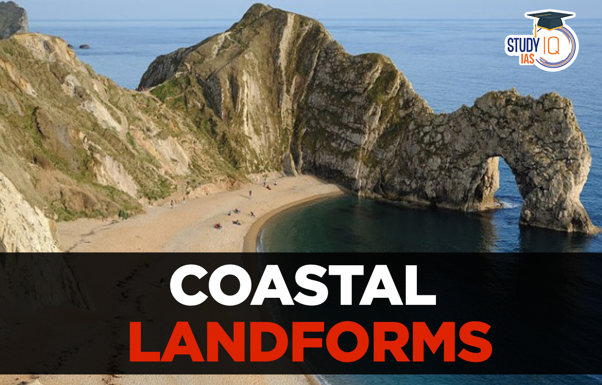
- Caves, Arches, and Stacks: These features form when waves erode softer rock layers. First, a cave forms from the force of the water. Over time, the cave can turn into an arch. Eventually, if the arch collapses, it leaves behind a tall, isolated rock column called a stack.
- Spits and Tombolos: Spits are narrow strips of sand or gravel that extend from the coastline into the sea, formed by the deposition of sediment carried by longshore drift. Tombolos are similar features but connect an island to the mainland.
- Barrier Islands: Barrier islands are long, narrow islands parallel to the coastline, separated from the mainland by a lagoon or bay. They provide protection to the mainland from waves and storms.
- Estuaries and Deltas: Estuaries are semi-enclosed coastal bodies of water where freshwater from rivers meets and mixes with saltwater from the sea. Deltas form at the mouths of rivers where sediment carried by the river is deposited, often creating intricate networks of channels and marshes.
- Headlands and Bays: Headlands are high land areas that stick out into the sea, while bays are curved coastal areas surrounded by land on three sides. Both are formed by the uneven erosion of coastal rocks.
- Lagoons: Lagoons are shallow bodies of water separated from the open sea by barrier islands or spits. They can be found in coastal areas with low wave energy.
Significance of Coastal Landforms
The significance of coastal landforms extends across ecological, economic, recreational, and geological domains, making them essential features of our planet’s landscape. Here’s an exploration of their significance:
- Ecological Importance:
- Provide habitats for diverse flora and fauna.
- Act as nurseries for marine life.
- Offer natural protection against erosion and storm surges.
- Economic Value:
- Tourism and recreation industries.
- Support commercial and recreational fishing.
- Serve as hubs for shipping and trade.
- Recreational Opportunities:
- Offer leisure activities like beach-going, water sports, and wildlife viewing.
- Attract millions of visitors annually for relaxation and adventure.
- Geological and Scientific Value:
- Preserve geological records of Earth’s history.
- Provide research opportunities in various scientific fields.
- Facilitate monitoring and conservation efforts for coastal environments.
 Lokmanya Tilak Jayanti 2026: Biography, ...
 Sex Ratio in India 2026: Latest Trends, ...
 Civil Disobedience Movement (CDM): Cause...