Table of Contents
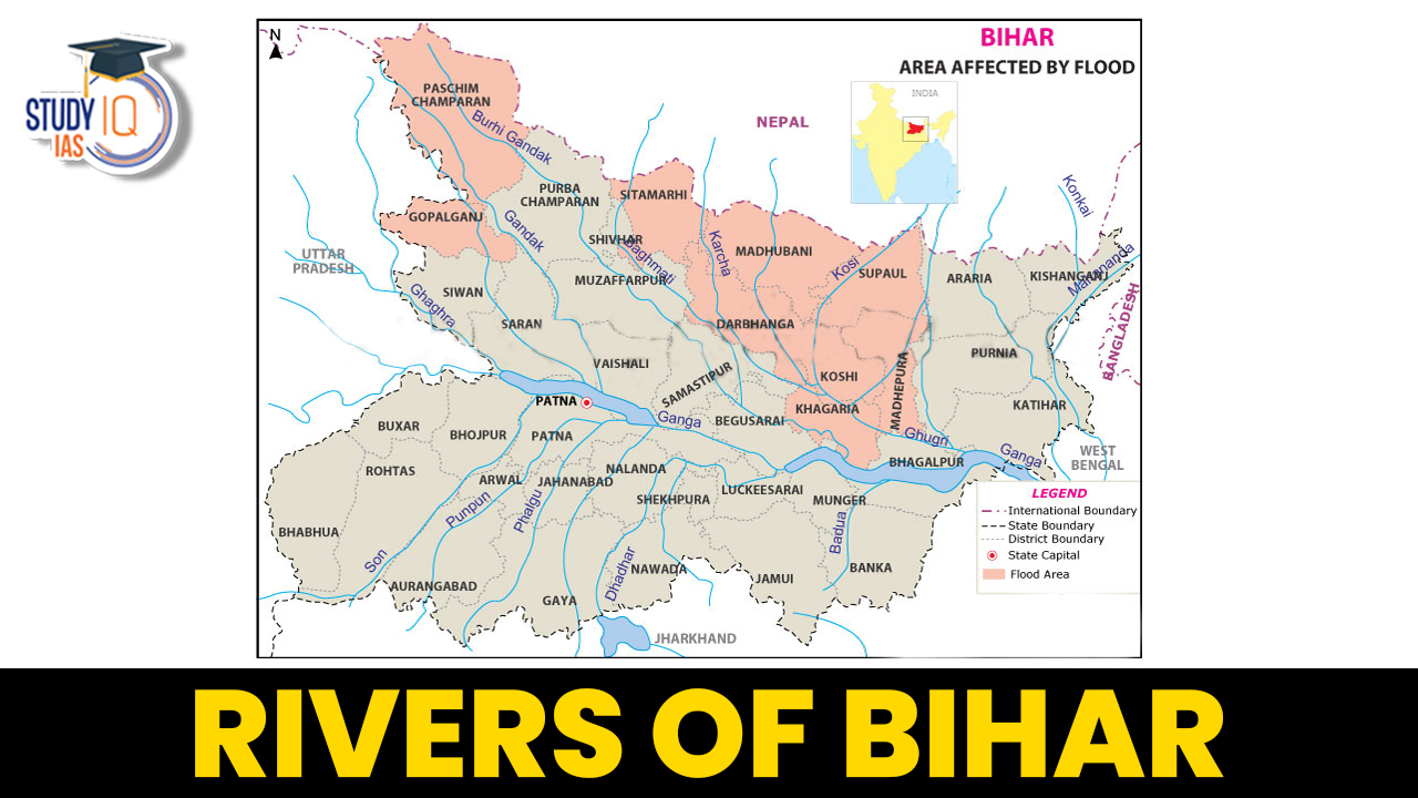
Rivers of Bihar
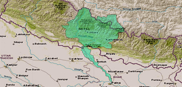
Bihar has an area of 3.82 lakh hectares of water, which is 4.1 per cent of the total geographical area of the state. Bihar is located in the eastern part of India which is in the central portion of the Indo-Gangetic plain and is bounded by the Himalayas from the north and the plateau from the south which is the source of the entire river flowing here. Although an entirely landlocked state, Bihar is very rich in water resources, both ground and surface water resources. The rivers of Bihar form the major source of surface water resources. River Ganga is the base of the Drainage System of Bihar. The Drainage System of Bihar is trellis and dendritic due to physical condition.
Bihar is a completely agriculture-based state, and here the rivers play an important role in making the economy of the state. This state is endowed with many places with many seasonal and perennial rivers. These form the source of surface water in this state. Some of the northern and southern alluvial state tracts have the availability of water throughout the seasons. The Ganga River separates this state into two unequal parts. Additionally, the rivers of Bihar are split into two groups based on where they are located, namely the rivers of the South Rivers of Bihar and the North Rivers of Bihar.
Read about: Rivers of India
Northern Rivers of Bihar
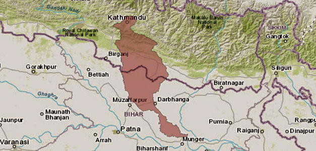
The rivers of North Bihar originate from the mountain ranges of the Himalayas. These includes Ghaghra, Gandak, Budhi Gandak, Bagmati, Kosi and Mahananda etc. All the rivers flowing in North Bihar flow from the plains of Bihar and join the river Ganga flowing through the central part of Bihar. Most of the rivers flowing from the Himalayas are continuous and receive water from the rains in the rainy season and the melting of the glaciers located in the mountainous areas in the summer. The Gandak, Karmnasa and Ghaghra rivers determine the boundary between Bihar and Uttar Pradesh.
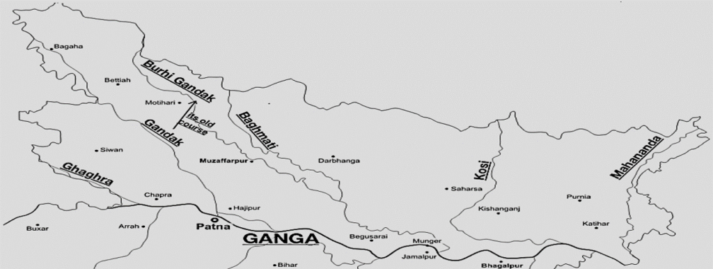
Characteristics of Northern Rivers of Bihar
- The Himalayas are the source of these rivers. These rivers are situated between Tibet and Nepal as a result of this.
- These northern rivers experience 80 times more precipitation during the monsoon season than during other times of the year.
- These northern rivers create Oxbow lakes (Chairs) as a result of the shifting course mechanism.
- These rivers are disastrous because of their upper portions’ high levels of siltation and steep slopes.
Read about: Indus River System
Southern Rivers of Bihar
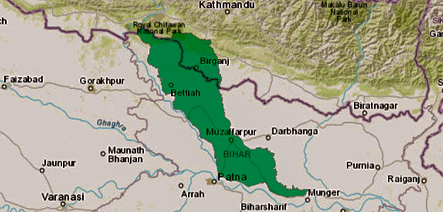
The Kiul, Son, Badua Chandan, and Karmnasa rivers which flow into the Ganga drain large portions of the southern plains of Bihar, according to the Bihar river map.
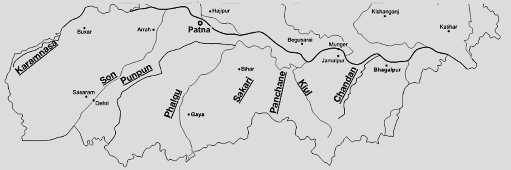
Characteristics of Southern Bihar Rivers
- These rivers have their source in the Vindhyachal Hills, Chhotanagpur Hills, or Rajmahal Hills.
- The drainage of the area is hampered by leaves on the southern side of the River Ganga.
- Due to the many rivers’ courses, land formations on the southern plains are known as Tal (Low-lying Areas).
Read about: Brahmaputra River
List of Rivers of Bihar
A detailed list of the River of Bihar has been provided in the table along with their tributaries and other details below:
| List of Rivers of Bihar | |||||||
| Name of Basin | Total Catchment Area(Sq.km) | Catchment in Bihar(Sq Km) | Name of Main River | Length of Main River in Bihar(Km) | Left Bank Tributaries | Right Bank Tributaries | Flood Prone Area(Sq.Km) |
| Ghaghra | 127950 | 2995 | Ghaghra | 83 | Little Gandaki,Sondhi Nala,Jharahi and Daha | Nil | 2530 |
| Gandak | 40553 | 4188 | Gandak | 260 | Bhabsa,Harha | Kakra | 3350 |
| Burhi Gandak | 12021 | 9601 | Burhi Gandak | 320 | Masan, Balor,Pandai,Sikta,balan,Tilawe,Tiur | Dhanauti,Kohra,Danda-Fardo-Danda-Kedane-none-Balane | 8210 |
| Bagmati-Adhwara | 14384 | 6500 | Bagmati | 394 | Lakhandei,Darbhanga Bagmati,old Kamla | Lalbakeya,Hasanpur bagmati | 4440 |
| Kamla-Balan | 7232 | 4488 | Kamla | 120 | Sugarave,Dhauri,Soni ,Balan | Nil | 3700 |
| Kosi | 74030 | 11410 | Kosi | 260 | Fariani Dhar,Dhemana dhar | Bagmati,Kamla balan ,Bhutahi balan,trijugi | 10150 |
| Mahananda | 23700 | 6150 | Mahananda | 376 | Donk | Balason,chenge,Mechi,Eastern Kankai,western Kankai,Parman | 5150 |
| Main Ganga Stem | 136970 | 16205 | Ganga | 445 | Ghaghra,Gandak,burhi-Gandak,Kosi,Mahananda | Karmnasa, Son,Punpun,kiul-Harohar, Badua, Chandan | 12920 |
| Karmnasa | 7792 | 5127 | Karmnasa | 24 76 km (forms Common boundary between Bihar and UP) |
Nil | Dharmawati,Gopai,Durgawati | Nil |
| Son | 70228 | 1483 | Son | 202 | Nil | Nil | 3700 |
| Punpun | 9026 | 7536 | Punpun | 235 | Mohrahar, Dardha | Dhowa | 6130 |
| Kiul-Harohar | 17225 | 12806 | Kiul | 41 | Sakari ,falgu,Mohane Paimar,Panchane and Harohar | Nil | 6340 |
| Badua | 2215 | 2215 | Badua | 130 | Belharna,Gobra Nala | Chanan,Barne nala,Kamjori | 1050 |
| Chandan | 4093 | 2371 | Chandan | 118 | Orhni ,Kudar | Chatri | 1130 |
| Source: Second Bihar State Irrigation Commission Report,1994 | |||||||
Read about: Monsoon in India
Detailed List of Rivers of Bihar
The detailed list of rivers in Bihar state has been discussed below:
Ghaghra River
The Ghaghra river basin has a total catchment area of 1,27,950 Sq Km, of which the area lying in Bihar is 2995 Sq Km, the rest 70,303 Sq Km being in Nepal and 54,652 Sq km in UP. Sixteen districts of UP and three districts namely Gopalganj, Siwan and Chapra of Bihar are covered by the catchment of this basin in India. Nearly the entire plains of the catchment lie below the south of the Indo-Nepal border line in India. This forms part of the alluvial Gangetic plains.
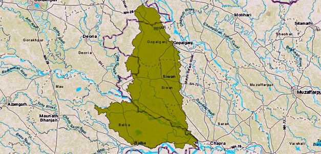
In Bihar State, the tributaries such as the Little Gandak, the Jharahi and the Daha joining the Ghaghra on its left bank flow through silted cross sections. There are also some low-lying lands called `Chaurs’ which remain submerged for a considerable period due to drainage congestion.
| Ghaghra River | |
| Total Length of Main River in Bihar | 83 Km |
| Average annual Rainfall | 1200 mm |
| Total length of Embankment | 132.9 Km |
| Area protected by flood | 790 Sq Km |
| Flood Prone Area | 2530 Sq. Km |
| Source: Second Bihar State Irrigation Commission Report,1994 | |
Gandak River
The total catchment area of the Gandak river basin upto its outfall into the Ganga is 40,553 Sq Km of which- 4,188 Sq Km lie in Bihar, 895 Sq Km lies in UP and the rest 35,470 Sq Km lies in Nepal. The basin is roughly trapezoidal in shape up to Valmiki Nagar. The river has a very steep slope in the mountains but after it debouches into the plains, the slope gradually becomes flatter. Like other rivers of North Bihar, it also brings an enormous quantity of sediment load along with its flow during the monsoon period.
The river Gandak flows more or less on the ridge line and therefore, any breach in the banks causes great devastations. The problem of flooding gets` further aggravated when the Ganga is also in flood simultaneously and the outfall of the river Gandak is choked resulting in backflow of the Ganga into the Gandak. The river has been embanked on both banks and the problem is one of proper maintenance of these embankments. Any breach in the embankment, therefore, results in catastrophe in the area.
| Gandak River | |
| Total Length of Main River in Bihar | 260 Km |
| Average annual Rainfall | 1125 mm |
| Total length of Embankment | 511.66 Km |
| Area protected by flood | 6240 Sq Km |
| Flood Prone Area | 3350 Sq. Km |
| Source: Second Bihar State Irrigation Commission Report,1994 | |
Burhi Gandak
The catchment area of the Burhi Gandak is 12,021 Sq Km out of which 2420 Sq Km of the hilly catchment lies in Nepal and the rest 9601 Sq Km lies in Bihar. The catchment is fan-shaped up to the confluence of the Dhanauti and thereafter its shape is elongated, narrow and rectangular. The Burhi Gandak river basin is bounded by the Someshwar range of hills in the north, the Bagmati basin in the east, the Gandak river basin in the west and the main Ganga stem in the south.
The sediment brought by Burhi Gandak river formed inland deltas where the steep slope of terai converged into the flat slope of the plains. This resulted in the meandering and braiding tendencies in the river leading to shifting of courses. Such changes in the river course and avulsions and cut-offs of the meander loops formed local depressions known as Mauns. The Burhi Gandak river basin has numerous gullies and ridges and also saucer type natural depressions locally known as chaurs. The southern portion of the basin, however, is fairly level and without much undulation.
| Burhi Gandak River | |
| Total Length of Main River in Bihar | 320 Km |
| Average annual Rainfall | 1283 mm |
| Total length of Embankment | 779.26 Km |
| Area protected by flood | 6730 Sq Km |
| Flood Prone Area | 8210 Sq. Km |
Bagmati River
The total catchment area of the basin is 14,384 Sq Km including the catchment of the Bagmati-Adhwara group of rivers. This basin is located on the south of the Himalayan range in Nepal and north of the river Ganga in India and lies between the Burhi Gandak basin on the West and the Kamla-Balan basin on the east.
The Bagmati river system carries a lot of sediment load contributed by its own catchment as well as its tributaries which has put the river regime in disarray and created problems like drainage congestion, meandering of the river course, rising of the river bed resulting in rising of the flood level and reduction in channel capacity etc.During floods the rivers of the basin spill over its banks and inundate large part of lands in the district of Sitamarhi, East Champaran, Muzaffarpur, Darbhanga, Samastipur and Khagaria.
| Bagmati River | |
| Total Length of Main River in Bihar | 394 Km |
| Average annual Rainfall | 1255 mm |
| Total length of Embankment | 478.14 Km |
| Area protected by flood | 1800 Sq Km |
| Flood Prone Area | 4440 Sq. Km |
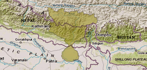
Kosi River
The Kosi drains a total catchment area of 74030 Sq Km out of which only 11410 Sq Km lies in India and the rest 62620 Sq Km lies in Tibet and Nepal. It is a snowfed river and hence perennial. The catchment area falling within Indian territory is distributed under several districts of Bihar namely –
- Madhubani
- Darbhanga
- Saharsa
- Supaul
- Madhepura
- Araria
- Purnea
- Katihar
- Bhagalpur
- Khagaria
The Kosi brings enormous amount of silt from the Himalayas mostly between the months of July to September. The silt load is deposited in the bed as the river travels in the plains and causes the river to spill its banks and shift its course. Such excessive deposition of silt has resulted in reduction of the channel capacity gradually and lots of shoals and islands have been formed in the bed of the river.
Due to excessive quantity of silt load being brought down by it during monsoon period, the river Kosi is known to have shifted its course about 112 Km to the west in the last 250 years. Unlike many rivers in India the river Kosi does-not have any defined flood plain. The flood problem gets aggravated when the Ganga is also in flood simultaneously and the outfall of the river Kosi is choked resulting in back flow of the Ganga waters into the Kosi.
The districts on the left bank of the river Kosi are flood prone
- Supaul
- Saharsa
- Madhepura
- Araria
- Purnia
- Katihar
The districts on the right bank of the river Kosi are flood prone
- Madhubani
- Darbhanga
- Khagaria
| Kosi River | |
| Total Length of Main River in Bihar | 260 Km |
| Average annual Rainfall | 1456 mm |
| Total length of Embankment | 637.41 Km |
| Area protected by flood | 9720 Sq Km |
| Flood Prone Area | 10150 Sq. Km |
Mahananda River
The river Mahananda drains a total catchment area of 23700 Sq Km, out of which 6150 Sq Km lies in Bihar and rest 17550 in Bangladesh, Nepal and West Bengal. It is bounded by the Himalayas in the north, the ridges separating it from the Tista river system in the east, the Ganga in the south and the Kosi in west.
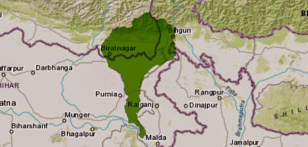
The river Mahananda brings enormous amount of silt from the Himalayas. Due to excessive deposition of silt the capacity of the river channel has been gradually reduced resulting in meandering tendency of the river in the alluvial plains and over bank spilling during floods.
| Mahananda River | |
| Total Length of Main River in Bihar | 376 Km |
| Average annual Rainfall | 1563 mm |
| Total length of Embankment | 225.33 Km |
| Area protected by flood | 1010 Sq Km |
| Flood Prone Area | 5150 Sq. Km |
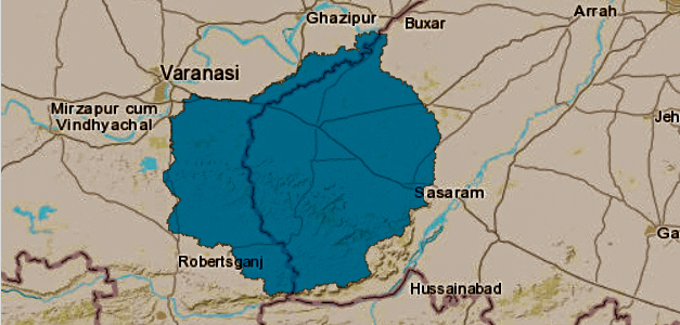
Karmnasa River
The Karamnasa River basin is situated between latitudes 24 32 N and 25 31 N and longitudes 83 0 E and 84 5 E. The Karamnasa rises near Sarodag on the northern face of the Kaimur range about 29 km west of Rohtasgarh in Mirzapur district of UP at an elevation of 350m and forms a boundary between Bihar and UP from the point River Gurwat joins Karamnasa. Then it flows through Varanasi district in UP and finally falls in Ganga near Chausa. Its important tributaries are the Durgawati, the Gurwat and Chandraprabha. The Total geographical area of the basin is 5127 sq km. The total length of the river is 192 km of which 92 km lies in UP, 24 km in Bihar and balance 76 km forms the common-boundary between Bihar and UP. Its other tributaries are Lorse, Kumda, Geria, Dharmawati etc.
| Karmnasa River | |
| Total Length of Main River in Bihar: | 24 76 km (forms Common boundary between Bihar and UP) |
| Average annual Rainfall: | 929 mm |
| Total length of Embankment: | NIL |
| Area protected by flood: | NIL |
| Flood Prone Area: | NIL |
Son River
The Son basin extends over an area of 70228 Sq Km and covers large areas in the states of Madhya Pradesh, UP and Bihar,15820 Sq Km of its catchment area lies in Bihar and Jharkhand and 1483 SQ.Km in Bihar as per GIS.
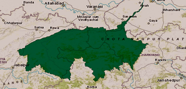
In 1975, the flood due to spill of the river Son in its lower reach resulted in flooding of the entire Danapur and most part of the Patna town causing extensive damage to private and public properties. Practically there appears no silt problem in the Son basin because annual silt load does not follow a regular pattern. This basin covers Rohtas, Bhojpur, Aurangabad and Patna districts.
| Son River | |
| Total Length of Main River in Bihar | 202 Km |
| Average annual Rainfall | 954 mm |
| Total length of Embankment | 59.54 Km |
| Area protected by flood | 210 Sq Km |
| Flood Prone Area | 3700 Sq. Km |
Punpun River
The Punpun basin drains a total catchment area of 9026 Sq Km lies in Bihar and Jharkhand and 7536 Sq.Km in Bihar. The catchment covers the districts of Patna, Jahanabad, Gaya, Aurangabad. Due to low bank and inadequate channel capacity, all the channels in the lower reaches spill heavily over their banks even during norinal floods. Spilling is more acute on both banks of the Punpun north of Jahanabad-Kinjer road. The spill of the Punpun after flowing north-eastwards meets the spills of its’ two. tributaries the Morhar and the Dardha.
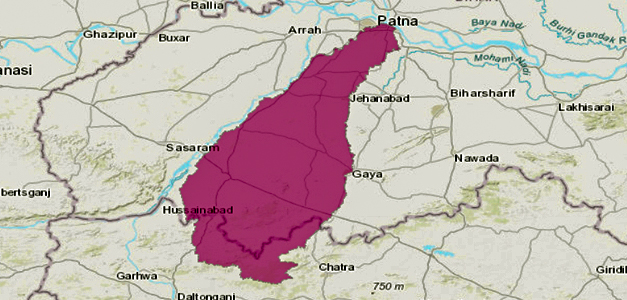
The spilling of flood water on left bank of the Punpun has, however, been checked to a great extent after construction of its left bank embankment under Patna Town Protection Scheme. The flood situation worsens during the period when the Ganga is in high stage simultaneously and the Ganga back water flow enters into the Punpun and the Dardha and the Dhowa river system resulting inundation of a large area besides adversely affecting the Mokama Tal area.
| Punpun River | |
| Total Length of Rivers in Bihar | 235 Km |
| Average annual Rainfall | 954 mm |
| Total length of Embankment | 37.62 Km |
| Area protected by flood | 200 Sq Km |
| Flood Prone Area | 6130 Sq. Km |
Kiul River
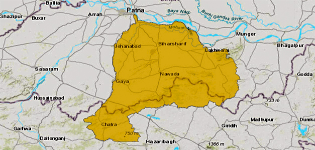
The Kiul-Harohar river system drains an area of 17225 Sq Km in Bihar and Jharkhand and 12806 Sq.Km in Bihar as per GIS. The upper catchment of the river system lies in Chotanagpur plateau area which is characterised by low hills and slopes with depressions and valleys.
The flood problems of Kiul river basin are not of very serious nature like those of the river basins of North Bihar. However, flash floods have been occurring during period of heavy rains in the catchment. The Kiul and the Harohar rivers flow almost on the ridges in their lower reaches.
| Kiul River | |
| Total Length of Main River in Bihar | 41 Km |
| Average annual Rainfall | 1104 mm |
| Total length of Embankment | 14 Km |
| Area protected by flood | 60 Sq Km |
| Flood Prone Area | 6340 Sq. Km |
Chandan River
The basin is situated between latitudes 240 30 N and 220 51 N and Longitudes 840 36 E and 870 27 E. The basin is drained independently by the river Chandan and the chir. The river Bilasi runs almost parallel to the Chandan river on its left and falls into Chandan which ultimately outfalls into the Ganga.
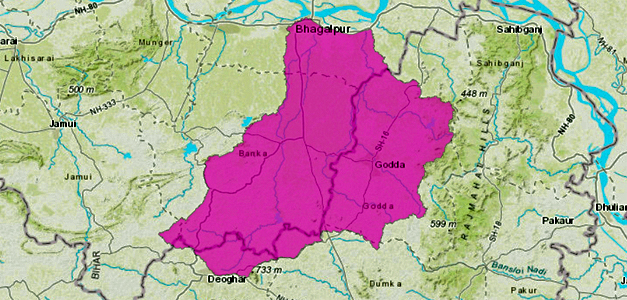
The watershed of these three rivers have been grouped together as one basin.The river originated from the hills of Deoghar in Jharkhand state at an elevation of 274 M and after travelling 110Km length bifurcates into number of small channels with deltaic river characteristic before meeting the river Ganga through Jamunia Nala. The important tributaries of Chandan are Orhni, Kuldar and Chatri.
| Chandan River | |
| Total Length of Main River in Bihar | 118 Km |
| Average annual Rainfall | 118 mm |
| Total length of Embankment | 83.18 Km |
| Area protected by flood | 1640 Sq Km |
| Flood Prone Area | 1130 Sq. Km |
Read about: Important Dams in India
 Operation Amistad: India's Humanitarian ...
 World MSME Day 2026: Theme, History, Sig...
 FIFA World Cup Winners List From 1930-20...