Table of Contents
Drainage System of Bihar
Drainage systems, commonly referred to as river systems in geomorphology, are the patterns created by the streams, rivers, and lakes in a specific drainage basin. A drainage system is governed by the topography of the land, which is dominated by hard as well as soft rocks.
Bihar is situated in the central portion of the Indo-Gangetic plain. The portion lying on the northern side of the left bank of the Ganga is known as north Bihar and that lying on the southern side as south Bihar. Under the existing drainage system in Bihar, mainly rivers, lakes, wetlands, waterfalls and various hot water bodies are included. Under this drainage system, irrigation is done in the entire state through canals and tube wells, ponds and wells extracted from various rivers. Check the Drainage System of Bihar overview in the table below:
| Drainage System of Bihar | |
| Particulars | Data |
| Geographical Area of Bigar | 94163 Sq. Km |
| Bihar Population (2011 census) | 103,804,637 |
| Number of Districts in Bihar | 38 |
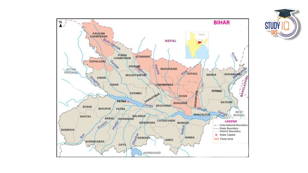
| Number of flood prone districts in Bihar | 28 |
| No. of River Basins in Bihar | 14 |
| Bihar Average annual Rainfall | 1205 mm |
| Bihar Flood Prone Area | 68800 Sq. Km |
| Total length of Embankment (Dams) Constructed in Bihar | 3759.94 Km |
| Area protected by flood in Bihar | 36,460.46 Sq Km |
| Source: Second Bihar State Irrigation Commission Report,1994 | |
Drainage System and Rivers of Bihar
Bihar has an area of 3.82 lakh hectares of water, which is 4.1 per cent of the total geographical area of the state. The base of the drainage system of Bihar is the river Ganges. The Ganges and its tributaries have played an important role in developing the topographical features of Bihar. On the basis of the origin of the rivers, the rivers of Bihar can be divided into two categories-
Rivers of North Bihar
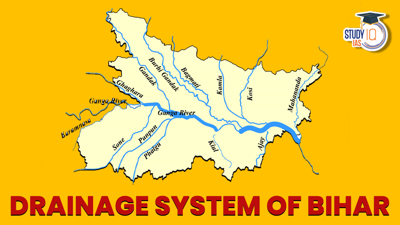
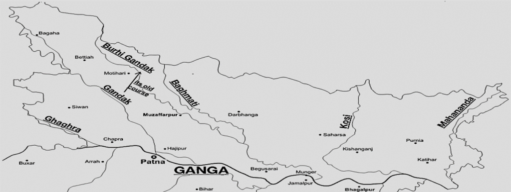
The rivers of North Bihar originate from the mountain ranges of the Himalayas. These include Ghaghra, Gandak, Budhi Gandak, Bagmati, Kosi and Mahananda etc.
Rivers of South Bihar
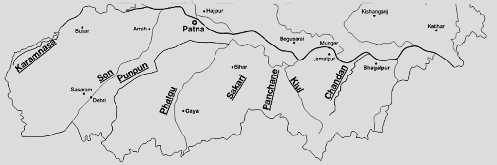
The rivers of south Bihar originate from varied sources. These include Son, Karmnasha, Punpun, Ajay, Kiul, Falgu,
Drainage System: 14 Drainage Basins of Bihar
As per the “Second Bihar State Irrigation Commission 1994” report, the rivers of Bihar have been divided into 14 basins such as:
| 14 Drainage Basins of Bihar | |
|
|
The Ganga flowing from west to east in this state is the main drainage channel with seven major rivers/basins namely Ghaghra, Gandak, Burhi-Gandak, Kamla Balan, Bagmati, Kosi and Mahananda on its north and six namely Karmnasa, Sone, Punpun, Kiul-Harohar, Badua and Chandan on its south.
All the rivers excluding Burhi-Gandak joining Ganga on its left bank in Bihar originate from the Himalayas, flow through a considerable length in Nepal and a large part of their catchment falls in the glacial regions of the great Himalayas. These rivers are snow-fed and hence perennial.
About 80% to 90% of the annual rainfall occurs in monsoon months on account of the southwest monsoon. As a result, the entire northern region of this state is affected by flooding almost every year due to excessive rainfall in their catchment. The average annual rainfall in Bihar is 1205 mm with significant variations in its areal distribution.
Drainage System of Bihar Map
Check the Drainage System of Bihar Map for a better understanding of Bihar’s drainage system:
List of Rivers in Bihar
The List of Rivers of Bihar has been mentioned in the table provided below with their tributaries, flood-prone area etc:
| List of Rivers in Bihar | |||||
| Name of River | Left Bank Tributaries | Right Bank Tributaries | Flood Prone Area(Sq.Km) | Length of Embankment Constructed(Km) | Area Protected by flood(Sq.Km) |
| Ghaghra | Little Gandaki,Sondhi Nala,Jharahi and Daha | Nil | 2530 | 132.9 | 790 |
| Gandak | Bhabsa,Harha | Kakra | 3350 | 511.66 | 6240 |
| Burhi Gandak | Masan, Balor,Pandai,Sikta,balan,Tilawe,Tiur | Dhanauti,Kohra,Danda-Fardo-Danda-Kedane-none-Balane | 8210 | 779.26 | 6730 |
| Bagmati-Adhwara | Lakhandei,Darbhanga Bagmati,old Kamla | Lalbakeya,Hasanpur bagmati | 4440 | 478.14 | 1800 |
| Kamla-Balan | Sugarave,Dhauri,Soni ,Balan | Nil | 3700 | 203.9 | 5620 |
| Kosi | Fariani Dhar,Dhemana dhar | Bagmati,Kamla balan ,Bhutahi balan,trijugi | 10150 | 637.41 | 9720 |
| Mahananda | Donk | Balason,chenge,Mechi,Eastern Kankai,western Kankai,Parman | 5150 | 225.33 | 1010 |
| Main Ganga Stem | Ghaghra,Gandak,burhi-Gandak,Kosi,Mahananda | Karmnasa,sone,Punpun,kiul-Harohar,Badua,Chandan | 12920 | 596.92 | 2440 |
| Karmnasa | Nil | Dharmawati,Gopai,Durgawati | Nil | NIL | Nil |
| Sone | Nil | Nil | 3700 | 954 | 210 |
| Punpun | Mohrahar, Dardha | Dhowa | 6130 | 37.62 | 200 |
| Kiul-Harohar | Sakari ,falgu,Mohane Paimar,Panchane and Harohar | Nil | 6340 | 14 | 60 |
| Badua | Belharna,Gobra Nala | Chanan,Barne nala,Kamjori | 1050 | NIL | Nil |
| Chandan | Orhni ,Kudar | Chatri | 1130 | 83.18 | 1640 |
| Source: Second Bihar State Irrigation Commission Report,1994 | |||||
List of Lakes in Bihar
In the northern plains of Bihar, many natural visarpa lakes have been formed as a result of the discharge of rivers like Ganga, Budhi Gandak, Kosi and Mahananda, because due to the gentle slope in the plains, the velocity of the rivers becomes very slow, as a result of which the rivers unable to transport the sediments carried by them. These lakes are also known by the names of Taal, Chaur or Man etc. in the local language. A Lakes of Bihar has been mentioned below with their location:
| List of Lakes in Bihar | |
| Lake | Location |
| Kanwar Lake | Majhola village of Begusarai district of Bihar state |
| Kusheshwarsthan Lake | Kusheshwarsthan block of Darbhanga, Bihar. |
| Gogabil Lake | Manihari in the Katihar district of Bihar state. |
| Simri Lake | Simri Bakhtiyarpur block at a distance of 25 kilometres from Saharsa in the state of Bihar. |
| Jagatpur Lake | Bhagalpur district of the state |
| Udaipur Lake | West Champaran District. |
| Anupam Lake | Kaimur Wildlife Sanctuary, Kaimur District and Rohtas District of Bihar |
List of Waterfalls in Bihar
The List of major Waterfall in Bihar has been provided in the table below:
| List of Waterfalls of Bihar | |
| Waterfalls | Location |
| Kakolat Falls | in Kakolat hill (Nawada). |
| Durgavati Falls | Kaimur district |
| Karkat Falls | Kaimur Hills of Kaimur district. |
| Jiarkund Falls | on the Phulwaria River in the Bhojpur district. |
| Telhar Kund | Kaimur district on Bhabua and Paroudha roads |
| Okharin Kund | Rohtas district of Bihar |
| Sukhaldari Falls | Border of Uttar Pradesh, Madhya Pradesh and Bihar |
| Dhuan Kund Waterfall | Kav River in Tarachandi Hill, Sasaram (Rohtas district). |
List of Hot Springs in Bihar
Most of the hot springs in Bihar are located in Rajgir and Munger districts. Apart from this, hot springs are also found in Gaya and Nalanda districts. Generally, they are related to dead volcanic activities or radioactive minerals located in the ground. Sulphur, minerals and salts etc. are found in sufficient quantity in the water coming out of hot water bodies. Hot water bodies are mainly found in igneous and metamorphic rocks. The temperature of their water is about 70°C, which remains almost the same throughout the year. Check the List of Hot Springs of Bihar below:
| List of Hot Springs of Bihar | |
| Springs | Location |
| Brahmakund | Rajgir (hottest 87°C) |
| Suryakund | Rajgir |
| Rishikund | Munger |
| Laxman Kund | Munger |
| Saptadhara/Satdharva | Rajgir |
| Makhdoom Kund | Rajgir |
| Sita Kund | Munger |
| Rameshwar Kund | Munger |
 Nicobarese Tribal Governance Debate 2026...
 Influence of Indian Ideas on Southeast A...
 Global Peace Index 2026: Top 10 Safest C...