Table of Contents
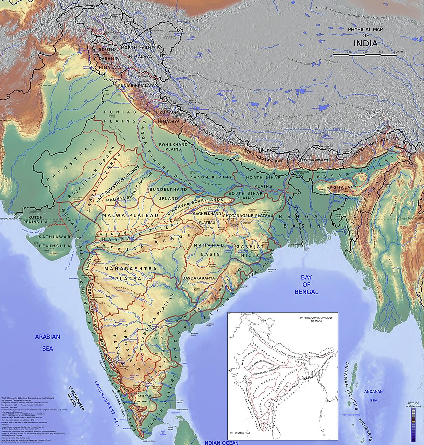
The Peninsular Plateau, Chota Nagpur Plateau, Bundelkhand Upland, and Central Highland are only a few examples of the plateaus in India. Any area of land with a flat top and has height less then 1000 m are called a plateau. A plateau is a large, flat area of land that is sometimes surrounded by mountains. It has steep hills called escarpments around it. Plateaus are usually higher than the land around them but not too steep. One of the oldest plateaus in the world is in India’s Deccan region. Plateaus are important because they have many minerals, which is why a lot of mining happens in these areas.
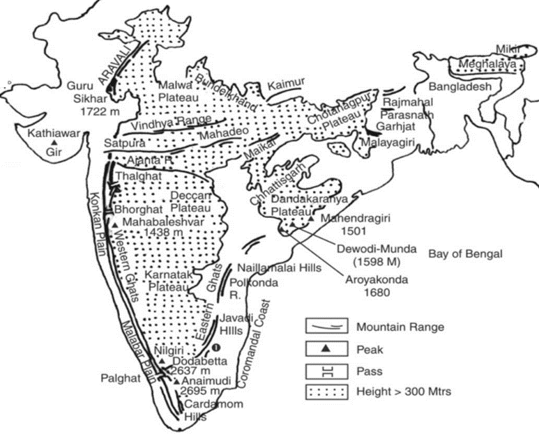
Plateaus in India Map
Plateaus in India can be studied as part of the Geography in the UPSC Syllabus. Plateaus are a type of Secondary Landforms which also include mountains, plains, and hills.
Plateaus in India Overview
Plateau in Indian are the large, flat region of land, sometimes surrounded by mountains but typically surrounded by escarpments. Typically, plateaus are formed when magma rises to the surface from a deep region of the earth but cannot pierce the crust. Certain plateaus are located distant from mountain ranges, like the Deccan plateau in central India. The Overview of Plateaus in India have been provided below:
| Plateaus in India Overview | |
| Particulars | Details |
| Largest Plateau in India | Deccan Plateau |
| How many Plateaus are there in India | There are a total of seven Plateaus in India. |
| Major Plateaus in India | The Marwar Plateau, Central Highland, Bundelkhand Upland, Malwa Plateau, Baghelkhand, Chota Nagpur Plateau, Meghalaya Plateau, Deccan Plateau, and Maharashtra Plateau |
Plateaus in India
The peninsular plateau of India is composed of Different types of Rocks as crystalline, igneous, and metamorphic materials. As a result of the breakdown and drift of the Gondwana continent, it is one of the oldest landmasses. There are shallow, wide valleys and rounded hills on the plateau. This plateau is divided into the Central Highlands and the Deccan Plateau.
- Mineral Resources abound on India’s plateaus.
- India’s Chota Nagpur plateau contains enormous deposits of iron, coal, and manganese.
- The river drops from a tremendous height in the plateau regions, so there can be more than one waterfall there. The Hundru Falls on the river Subarnarekha on the Chota Nagpur plateau and the Jog Falls in Karnataka are two examples of these waterfalls in India.
- On the lava plateaus, the majority of the black soil is rich and suitable for farming.
- The patch of black dirt known as the Deccan Trap is one of the distinguishing characteristics of the Peninsular plateau. The rocks are igneous because they are made of Volcanic Eruption.
- On the Peninsular Plateau’s western and northern edges lie the Aravalli Hills.
- These have hills that have degraded and look fractured. They go in a southwest-northeast route from Gujarat to Delhi.
Also Read – Tibetan Plateau and Its Geographical Importance
Plateaus in India – Peninsular Plateau
One of India’s plateaus is the Peninsular Plateau. It looks like a triangle, with its base at the bottom of the North Indian plain and the top near Kanyakumari. This plateau is very large, covering over 1.6 million square kilometers, and it usually sits 600 to 900 meters above sea level.
- The Peninsular Plateau is one of Earth’s oldest geographical landforms.
- The peninsula’s basic slope is indicated by the fact that the majority of its rivers flow from west to east.
- An unusual river that flows in a fissure from east to west is the Narmada-Tapti.
- Numerous smaller plateaus, hilly terrain, river basins, and valleys make up the Peninsular Plateau.
- This incredibly solid block is composed primarily of Archaean gneisses and schists.
Types of Plateaus in India
There are seven Plateaus in India in total. The seven plateaus are referred to as the Marwar Plateau, Central Highland, Bundelkhand Upland, Malwa Plateau, Baghelkhand, Chota Nagpur Plateau, Meghalaya Plateau, Deccan Plateau, and Maharashtra Plateau. All these Types of Plateaus in India have been discussed below.
Deccan Plateau
- The Deccan Plateau covers an area of about 500,000 square kilometers.
- Its triangle-shaped shape is defined by the Satpura and Vindhya in the northwest, the Mahadev and Maikal in the north, the Western Ghats in the west, and the Eastern Ghats in the east.
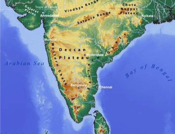
- The Deccan Plateau is typically 600 meters above sea level. From 500 meters in the north to 1000 meters in the south, the elevation changes.
- Its main rivers’ current direction provides a reliable indication of its general slope, which flows from west to east.
Maharashtra Plateau
- The Maharashtra Plateau, which is situated in Maharashtra, makes up the northern part of the Deccan Plateau. Most of the region is composed of basaltic rocks that were created by lava.
- The area has taken on the look of a rolling plain due to weathering.
- The horizontal lava sheets produced the step-like topography of the Deccan Trap.
- The broad and shallow basins of the Godavari, Bhima, and Krishna are surrounded by flat-topped, steep-sided hills and mountains.
- Regur, a soil of black cotton, covers the whole region.
Marwar Plateau
- The Marwar plateau is located in eastern Rajasthan. The Marwar plateau is to the east of Aravalis, and the Marwar plain is to the west.
- The Marwar plateau dips down to the east and is typically between 250 and 500 meters above sea level.
- Its components are limestone from the Vindhayan age, sandstone, and shales.
- Before joining the Chambal River in the northwest, the Banas River and its tributaries, the Berach River and the Khari River, originate in the Aravali Range.
- The plateau top appears to be a rolling plain due to the action of these rivers’ erosion.
Malwa Plateau
- The Malwa Plateau, which is generally shaped like a triangle based on the Vindhyan Hills, is surrounded by the Aravali Range in the west, Madhya Bharat Pathar in the north, and Bundelkhand in the east.
- The Narmada, Tapi, and Mahi rivers flow into the Arabian Sea from this plateau’s two drainage basins, while the Chambal and Betwa join the Yamuna to empty into the Bay of Bengal.
- It is drained in the north by the Chambal and numerous of its right bank tributaries, such as the Kali, Sindh, and Parbati. The Ken, Betwa, and upper courses of the Sindh are also included.
- It is covered in black soil and is composed of a huge lava flow.
- The sloping surface of this plateau is traversed by rivers. The plateau’s distinguishing feature is the Chambal ravines in the north.
Central Highland
- East of the Marwar or Mewar Upland is the Central Highland, also known as the Madhya Bharat Pathar or Madhya Bharat Plateau.
- The plateau is mostly composed of the basin of the Chambal river, which flows in a rift valley.
- The Kali Sindh, which rises from Rana Pratap Sagar, the Banas, which traverses the Mewar plateau, and the Parwan and Parbati, which rise from Madhya Pradesh, are some of its primary tributaries.
- It is a gently undulating plateau with rounded hills built of sandstone.
The ravines or badlands of the Chambal River are to the north. There are thick woodlands located here.
Bundelkhand Upland
- The Yamuna River, the Madhya Bharat Pathar, the Vindhyan Scarplands, the Malwa Plateau, and the Yamuna River all abut the Bundelkhand Upland to the north and west, respectively.
- The Plateau is an old dissected upland of the Bundelkhand gneiss, comprised of granite and gneiss, that descends down from the Vindhyan Scarp toward the Yamuna River.
- The Bundelkhand Upland is made up of four districts in Madhya Pradesh and five in Uttar Pradesh.
- The area’s distinguishing characteristic is a collection of granite and sandstone hillocks.
- Due to the erosive activity of the rivers that stream through it, it has an undulating (wave-like) surface that makes it unsuitable for farming.
- The plateau is traversed by a number of streams, including Betwa, Dhasan, and Ken.
Baghelkhand
- North of the Maikal Range is the Baghelkhand plateau. It is made of granite on the east and of limestone and sandstone on the west.
- The Son river defines Baghelkhand’s northern border.
- In the center of the plateau, a body of water divides the Mahanadi river system from the Son drainage system in the north.
- The Bhanrer and Kaimur are located not far from the trough axis.
- The strata’s overall horizontality suggests that there haven’t been any major upheavals.
Chota Nagpur Plateau
- The Chotanagpur plateau is the northeastern part of the Indian Peninsula and is mostly made of Gondwana rocks.
- It includes Jharkhand, northern Chhattisgarh, and Purulia district in West Bengal.
- The Son river flows into the Ganga to the northwest of the plateau.
- The plateau has a radial drainage pattern with many rivers and streams flowing in different directions.
- Major rivers like the Damodar, Subarnarekha, North Koel, South Koel, and Barkar have created large drainage basins.
- The Damodar river flows through a rift valley in the middle of this region from west to east and is a major source of coal in the Gondwana coal fields.
- The Rajmahal Hills are on the northeastern side of the Chotanagpur Plateau, made mostly of basalt and covered in lava flows.
Meghalaya Plateau
- The peninsular plateau extends eastward across the Rajmahal Hills to the Meghalaya or Shillong plateau.
- Shillong (1,961 m) is the highest peak on this plateau.
- The Garo-Rajmahal Gap separates this plateau from the main block.
- This gap was created by down-faulting and later filled with sediments from the Ganga and Brahmaputra rivers.
- The Meghalaya plateau slopes north toward the Brahmaputra valley and south toward the Surma and Meghna rivers.
- Its western edge aligns closely with Bangladesh’s border.
- The plateau has three sections: Khasi-Jaintia Hills (1,500 m) in the west, Mikir Hills (900 m) in the center, and Garo Hills (900 m) in the east.
Importance of Plateaus in India
Plateaus in India is one of the significant feature of the Physiography of India and it possesses abundance of natural resources, which has increased the country’s geographic and biological diversity. The plateau has always been a stunning element of nature that allows you to connect to several historical events and discover the biodiversity with old rocks. India has a vast variety of peninsular plateaus that are spread over many areas and boundaries. These triangle occurrences take the form of little hills surrounded by lovely scenery and various animal and plant species.
The Plateaus in India has a lot of noteworthy characteristics. India’s natural habitat is diverse and variable because of these characteristics.
Reservoirs of Minerals
Most of the world’s minerals are found in plateaus. It is easier to get minerals from plateaus than from mountains. Many raw materials used in making things come from plateaus. For example, we get gold from the plateaus in Western Australia, Africa, and India. In India, the Chottanagpur Plateau provides mica, iron, coal, and other metals.
Hydro Power Production
Plateaus in India have many waterfalls, with Jog and Hundru being the biggest ones. The edges of these plateaus are great spots for making electricity from water, called hydel electricity. The Koyna Hydroelectric Project is the largest power plant in India, producing 1960 megawatts of electricity. The Shivanasamudra Hydroelectric Power Plant is India’s first power station, located on the Kaveri River in Karnataka.
Agriculture and Animal Rearing
Plateaus have large grasslands, which are great for raising animals like sheep, goats, and cattle. Some plateaus, called lava plateaus, have very fertile soil, making them good for farming because they contain more minerals than other plateaus. In India, one plateau has rich black soil that contains iron. This black soil is excellent for growing crops, so it helps a lot with agriculture.
Plateau in India UPSC
The Peninsular Plateau, which stretches from the Aravallis in the north-west to the Shillong plateau in the north-east and Kanyakumari in the south, is the largest physiographic unit in India. It has a triangular form. It is made up of various tiny plateaus and mountains, covering an area of about 16 lakh square kilometers, and makes about 50% of the Indian continent. It is a prehistoric tabular block made up of Dharwar rock system, Schist, and Archean Gneiss. In addition, igneous Basalt rocks can be found in the Deccan plateau.
One of India’s oldest and most stable landmasses is this one. Since its establishment, it has only slightly changed structurally. Except for the few localized locations where marine infractions have occurred, it has never been submerged beneath the sea.
 UKSSSC High Court Recruitment 2026 Apply...
 UPSC Prelims Result 2026 LIVE: Result PD...
 UPSC Prelims Result 2026 Out: Check Roll...