Table of Contents
India is geographically positioned in Southern Asia, sharing both land and maritime borders with multiple countries, making its geography highly significant for strategic, economic, and cultural reasons. India ranks as the seventh-largest country in the world by area and second by population. With a vast geographical spread, it has land borders totaling 15,106.7 kilometers and a coastline stretching over 7,516.6 kilometers.
9 Neighbouring Countries of India
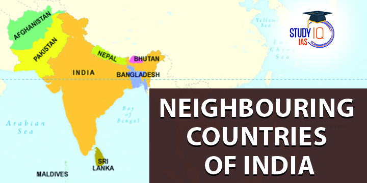
India shares its borders with a total of 9 countries, including 7 land borders and 2 sea borders. Understanding these neighbouring countries is crucial for various competitive exams, especially in the General Awareness section.
| S.No | Country | Bordering States |
| 1 | Afghanistan | Jammu and Kashmir (POK Part) |
| 2 | Bangladesh |
West Bengal, Mizoram, Meghalaya, Tripura, and Assam
|
| 3 | Bhutan |
Arunachal Pradesh, Assam, Sikkim, and West Bengal
|
| 4 | China |
Jammu and Kashmir, Himachal Pradesh, Uttrakhand, Sikkim, and Arunachal Pradesh
|
| 5 | Myanmar |
Arunachal Pradesh, Manipur, Mizoram, and Nagaland
|
| 6 | Nepal |
Sikkim, West Bengal, Bihar, Uttar Pradesh, and Uttrakhand
|
| 7 | Pakistan |
Jammu and Kashmir, Punjab, Gujarat, and Rajasthan
|
| 8 | Sri Lanka | Separated from India by Gulf of Mannar |
| 9 | Maldives |
The south-west part of the Indian Ocean below the Lakshadweep Island
|
1. Afghanistan
India and Afghanistan have strong ties and work together in business, technology, and culture. India is the biggest investor in rebuilding Afghanistan. India supports Afghanistan through various programs, including building infrastructure, helping strengthen institutions, and providing food aid with regular wheat deliveries. Since 2001, over 10,000 Afghan students have studied in India on scholarships. The bond of trust between the two countries is rooted in their shared history. Polls show that many Afghans feel positively about India and feel at home when they visit.
| Afghanistan |
|
2. Bangladesh
Bangladesh and India have a long shared history. India is dedicated to keeping good relations with its neighbors, and Bangladesh is one of them. India recognized Bangladesh as an independent country and fought alongside its people in 1971 to help free it from West Pakistan.
| Bangladesh |
|
3. Bhutan
India and Bhutan have always had good relations, and these have recently improved even more. Their partnership has helped both countries grow, especially through economic cooperation. Bhutan has received support from India in areas like telecommunications, education, and forestry. Overall, India is seen as a long-term business and development partner for Bhutan.
| Bhutan |
|
4. China
India and China have a close relationship. As their economies become more connected, the two countries are working together more closely. High-ranking officials and ministers from both countries visit each other often. In 2003, India officially recognized Tibet as part of China, and in 2004, China recognized Sikkim as part of India.
| China |
|
5. Myanmar
After Burma gained independence from the UK in 1948, India kept strong political ties with the country. Burma is located south of India’s northeastern states: Mizoram, Manipur, Nagaland, and Arunachal Pradesh. Its closeness to China makes the relationship between India and Burma strategically important. They share a long border and generally have friendly relations.
| Myanmar |
|
6. Nepal
Nepal is also a friendly neighbor of India. It shares borders with five Indian states: Sikkim, West Bengal, Bihar, Uttar Pradesh, and Uttarakhand, to the east, south, and west. To the north, it borders the Tibet Autonomous Region of China. There is a long history of free movement between the two countries. Nepal has a population of about 29 million people and covers an area of 147,181 square kilometers. The relationship between India and Nepal is based on many years of cultural connections.
| Nepal |
|
7. Pakistan
India and Pakistan have a complicated relationship. Pakistan has often been unfriendly toward India, while India has worked hard to improve and stabilize their ties. To help build trust and peace, both countries have put several measures in place.
| Pakistan |
|
8. Sri Lanka
India and Sri Lanka have a long history of friendship. Many Tamils in Sri Lanka have Indian roots, which has created a cultural connection. Over the years, their relationship has grown, with strong political and trade ties. Sri Lanka is India’s largest trading partner in South Asia, and India is Sri Lanka’s biggest global trading partner. Since the Free Trade Agreement started in March 2000, trade between them has increased rapidly.
| Sri Lanka |
|
9. Maldives
India and the Maldives have been friendly since 1981 when they signed a trade agreement. The Maldives is located south of India’s Lakshadweep Islands in the Indian Ocean. Both countries share strong ethnic, cultural, and commercial ties. India supports the Maldives in its economic development and maintains a close relationship with it.
| Maldives |
|
Also, Check Lakes of India
India’s Border Area
India shares a 15,200 km land border with their neighbouring countries. Lakshadweep Islands, Andaman and the Nicobar Islands are 7,516.6 km long in total of coastline of the mainland. Water boundaries are shared with the Maldives (from the south-west) and Sri Lanka (from the south-east). India shares seven borders: Afghanistan and Pakistan to the northwest, China, Bhutan, and Nepal to the north, Myanmar to the east, and Bangladesh to the east.
| Neighbouring Countries of India | |
| Total Neighbouring Countries Of India | 9 |
| Land border length | 15200 |
| Neighbouring Countries Of India | Afghanistan, Pakistan, China, Nepal, Bhutan, Bangladesh, Sri Lanka, Maldives and Myanmar |
| Total Length Of Indian Coastline | 7516.6 km |
Neighbouring Countries of India and their Capitals
We have discussed the Neighbouring Countries of India with their Capitals, along with the length of the border with India:
| Country | Capital | Length of Border with India |
| Afghanistan | Kabul | 106 km |
| Bhutan | Thimphu | 699 km |
| Bangladesh | Dhaka | 4156 km |
| China | Beijing | 3488 km |
| Myanmar | Naypyidaw | 1643 km |
| Nepal | Kathmandu | 1751 km |
| Pakistan | Islamabad | 3233 km |
| Sri Lanka | Sri Jayawardenepura Kotte (Legislative Capital) and Columbo (Executive Capital) | Separated by the Gulf of Mannar |
Also, Check Seasons of India
Neighbouring Countries of India in Detail
| Country | Important Facts | Important Information |
| Afghanistan |
|
Afghanistan is a landlocked, multiethnic country in south-central Asia. It is situated along important trade routes between southern and eastern Asia to Europe and the Middle East. |
| Bhutan |
|
Bhutan is a country in south-central Asia that is situated in the eastern Himalayan ranges. |
| Bangladesh |
|
Bangladesh is a country in South Asia that is situated in the Padma (Ganges) and Jamuna (Brahmaputra) river delta in the northeastern region of the Indian subcontinent. Bangladesh, a riverine country known as the “Land of the Bengals,” is one of the world’s most densely inhabited countries. |
| China |
|
China has the largest population of any nation in the world and is the largest of all Asian countries. it covers almost the entire area of East Asia. Only Russia and Canada are larger countries than China, and it is nearly as big as all of Europe. |
| Myanmar |
|
Myanmar is situated in the western part of mainland Southeast Asia. The Union of Burma, which had been the nation’s official English name since 1885, was changed to the Union of Myanmar in 1989. |
| Nepal |
|
Nepal is located along the southern Himalayan mountain ranges. It is a landlocked country bordered to the east, south, and west by India and to the north by China’s Tibet Autonomous Region. |
| Pakistan |
|
Pakistan is a populous, ethnically diverse country in South Asia. Pakistan has historically and culturally been linked to its neighbours Iran, Afghanistan, and India due to its predominantly Indo-Iranian-speaking people. |
| Sri Lanka |
|
The island nation of Sri Lanka is located in the Indian Ocean and is separated from peninsular India by the Palk Strait. |


 Districts of MP List, Name, Importance, ...
 Critical Minerals, Key Issues, Importanc...
 Grasslands in the World, Map, Types and ...


