Table of Contents
Tamil Nadu, a vibrant state located in southern India, is renowned for its rich cultural heritage, diverse landscapes, and historical significance. The state is divided into 38 districts, each with its unique administrative framework, demographics, and geographical features. This article provides a comprehensive list of the districts of Tamil Nadu, along with a brief overview of their areas, headquarters, and notable features.
Districts of Tamil Nadu
Tamil Nadu, a prominent southern state in India, has a rich cultural heritage and a well-structured administrative framework. Established in 1956 with just 13 districts, Tamil Nadu has grown to encompass 38 districts today, effectively catering to its diverse population and geographic landscape.
| Districts in Tamil Nadu Important Facts | |
| Total District in Tamil Nadu State | 38 |
| Date of Formation | 1 November 1956 |
| State Capital | Chennai |
| Total Area | 130,058 km2 |
| Total Population | 72,147,030 |
Read More: Districts of Karnataka List
Total Districts in Tamil Nadu
The number of Districts in Tamil Nadu has changed several times in recent years. The total number of districts in the state is currently 38. The state’s most recent district was added in 2020. Tamil Nadu has not created a new district since then. We have provided a brief history of Tamil Nadu districts here.
- The Chennai district’s border area was expanded on January 5, 2018.
- Tenkasi district was separated from Tirunelveli on November 22, 2019.
- Kallakurichi district was separated from Viluppuram district on November 26, 2019.
- Tirupattur and Ranipet districts of Tamil Nadu were separated from the Vellore district on November 29, 2019.
- Chengalpattu district was separated from Kanchipuram on November 30, 2019.
- Mayiladuthurai district was separated from Nagapattinam district on March 24, 2020.
Read about: Union Territories
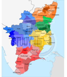
District of Tamil Nadu Map
To understand the districts of Tamil Nadu better, it is necessary to understand their geographical location within the state of Tamil Nadu. The Tamilnadu District Map is provided here to assist you in identifying the same.
Read about: Districts of India
List of Districts of Tamil Nadu
We’ve listed the names of all 38 districts in Tamil Nadu, as well as the dates each district was established. Check out the table below for more information on the districts of Tamil Nadu.
| No. | District | Headquarters | Area (km²) | Population (2021) |
|---|---|---|---|---|
| 1 | Ariyalur | Ariyalur | 2,027.6 | 754,894 |
| 2 | Chengalpattu | Chengalpattu | 2,802.6 | 2,556,244 |
| 3 | Chennai | Chennai | 462.3 | 6,748,026 |
| 4 | Coimbatore | Coimbatore | 4,304.8 | 3,464,679 |
| 5 | Cuddalore | Cuddalore | 3,746.4 | 2,564,584 |
| 6 | Dharmapuri | Dharmapuri | 4,622.4 | 1,484,769 |
| 7 | Dindigul | Dindigul | 6,266.6 | 2,235,702 |
| 8 | Erode | Erode | 2,825.1 | 2,033,154 |
| 9 | Kanchipuram | Kanchipuram | 4,280.4 | 2,880,829 |
| 10 | Karur | Karur | 2,756.5 | 1,045,118 |
| 11 | Krishnagiri | Krishnagiri | 5,255.7 | 1,059,357 |
| 12 | Madurai | Madurai | 3,730.1 | 3,058,868 |
| 13 | Nagapattinam | Nagapattinam | 2,509.1 | 1,698,068 |
| 14 | Namakkal | Namakkal | 3,117.7 | 1,359,052 |
| 15 | Perambalur | Perambalur | 1,862.1 | 565,223 |
| 16 | Pudukkottai | Pudukkottai | 4,700.0 | 1,156,698 |
| 17 | Ramanathapuram | Ramanathapuram | 4,500.6 | 1,047,893 |
| 18 | Salem | Salem | 5,323.3 | 3,708,927 |
| 19 | Sivaganga | Sivaganga | 4,208.3 | 1,012,437 |
| 20 | Thanjavur | Thanjavur | 3,350.5 | 2,458,777 |
| 21 | Theni | Theni | 3,122.5 | 1,210,879 |
| 22 | Tiruchirappalli | Tiruchirappalli | 4,529.2 | 2,747,278 |
| 23 | Tirunelveli | Tirunelveli | 6,313.8 | 1,705,020 |
| 24 | Vellore | Vellore | 6,295.4 | 2,197,200 |
| 25 | Villupuram | Villupuram | 3,626.5 | 2,615,454 |
| 26 | Tenkasi | Tenkasi | 3,489.5 | 1,059,657 |
| 27 | Tirupattur | Tirupattur | 2,458.0 | 1,014,399 |
| 28 | Ranipet | Ranipet | 2,642.4 | 1,294,634 |
| 29 | Tiruvannamalai | Tiruvannamalai | 4,389.0 | 1,062,840 |
| 30 | Thoothukudi | Thoothukudi | 4,351.2 | 1,697,309 |
| 31 | Tiruvarur | Tiruvarur | 2,512.2 | 1,127,246 |
| 32 | Mayiladuthurai | Mayiladuthurai | 1,595.7 | 547,925 |
| 33 | Kallakurichi | Kallakurichi | 2,735.5 | 1,071,302 |
Districts of Tamil Nadu Administrative Structure
Tamil Nadu’s districts are divided into numerous subdivisions. We have provided information about the state’s administrative structure here.
| Administrative Structure of Districts in Tamil Nadu | |
| Revenue Divisions | 87 |
| Taluks | 310 |
| Municipal Corporations | 15 |
| Municipalities | 121 |
| Blocks | 385 |
| Village Panchayats | 12,618 |
| Town Panchayats | 528 |
 APSC Answer Key 2026: Download Unofficia...
 APSC Question Paper 2026 PDF Out: Downlo...
 JPSC Civil Services Pre Result 2026 Out ...