Table of Contents
Context: ISRO conducted research on the growth of glacial lakes in the Indian Himalayan region and the associated risks of glacial lake outburst floods (GLOFs).
ISRO’s Analysis of Himalayan Glacial Lakes
- Used satellite data from 1984 to 2023 to assess changes in glacial environments.
- Found significant expansion in the size of glacial lakes in Indus, Ganga, and Brahmaputra basins.
- Identified 676 lakes that had expanded significantly since 1984, out of 2,431 lakes larger than 10 hectares.
- 601 lakes more than doubled in size, 10 lakes grew 1.5 to 2 times larger, and 65 lakes grew 1.5 times larger.
- 130 of the expanding lakes are in India.
Formation of Glacial Lakes
- Created by meltwater accumulating in depressions left by retreating glaciers.
- ISRO categorised glacial lakes into four types: moraine-dammed, ice-dammed, erosion-based, and others.
- Moraine-dammed lakes are formed by water dammed by debris left by glaciers.
- Ice-dammed lakes are formed by water dammed by ice.
- Erosion-based lakes are formed by water trapped in depressions created by erosion.
- Importance: Source of freshwater for rivers.
- Risks of Glacial Lakes:
- Glacial lake outburst floods (GLOFs) can have devastating consequences downstream.
- GLOFs occur when large volumes of meltwater are released due to dam failures.
- Dam failures can be triggered by avalanches or other factors.
| GLOF Risk Mitigation |
|
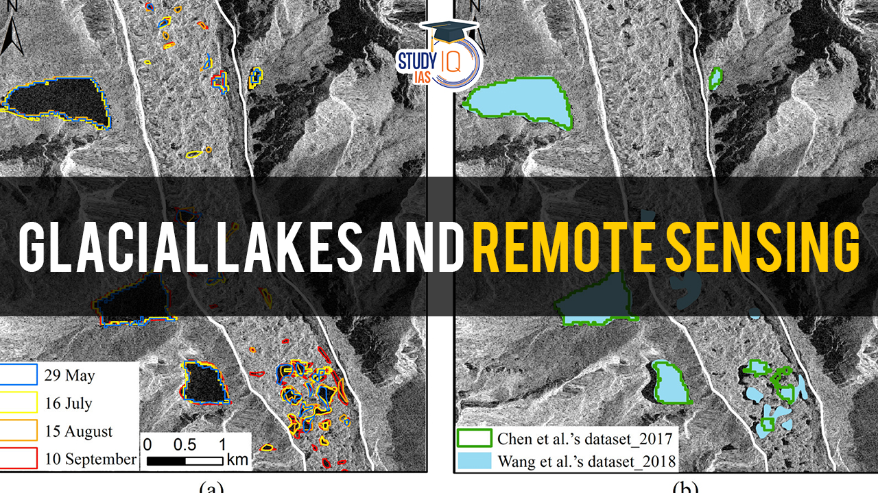
Role of Satellite Monitoring
- Challenging to monitor glacial lakes due to rugged Himalayan terrain.
- Satellite remote sensing is a valuable tool due to:
- Wide coverage
- Revisit capability
- Satellite data helps understand glacial lake dynamics for:
- Environmental impact assessment
- Developing strategies for:
- GLOF risk management
- Climate change adaptation
Key Findings
- Expansion of Glacial Lakes: The study reveals a significant expansion in the size of glacial lakes over the study period, with 676 lakes exhibiting notable growth since 1984. This expansion is attributed to the accelerated retreat of glaciers driven by global warming.
- Geographical Distribution: Of the expanded glacial lakes, 130 are located in India, primarily in the Indus, Ganga, and Brahmaputra river basins. This distribution highlights the regional significance of the issue and the implications for downstream communities.
- Formation Processes: Glacial lakes are categorized into four main types based on formation processes: moraine-dammed, ice-dammed, erosion-based, and others. Understanding these formation mechanisms is crucial for assessing associated risks and devising mitigation strategies.
- Risks of GLOFs: The proliferation of glacial lakes increases the risk of GLOFs, which can have catastrophic consequences for downstream settlements and infrastructure. Timely monitoring and mitigation efforts are essential to reduce the likelihood and impact of GLOFs.
Implications and Mitigation Strategies
- Remote Sensing for Monitoring: Satellite remote sensing emerges as a valuable tool for monitoring glacial lakes and assessing their dynamics. Continuous monitoring enables early detection of changes and facilitates proactive risk management.
- Mitigation Measures: The study highlights mitigation strategies to address the risks posed by glacial lakes, including lowering lake levels and implementing siphoning techniques using High-Density Polyethylene (HDPE) pipes. These measures can help mitigate the impacts of GLOFs and protect downstream communities.
Conclusion
The study underscores the urgent need to address the escalating risks associated with glacial lake expansion in the Himalayas. By leveraging satellite remote sensing technology and adopting proactive mitigation measures, stakeholders can mitigate the impacts of GLOFs and safeguard vulnerable communities. Continued research and collaborative efforts are essential to effectively manage the complex challenges posed by climate change in glacier-rich regions.
 Oor Pare Prehistoric Site: Location, Roc...
 Assam Election 2026: Exit Poll, Result D...
 Great Indian Bustard (GIB): Features, Th...