Table of Contents
Context
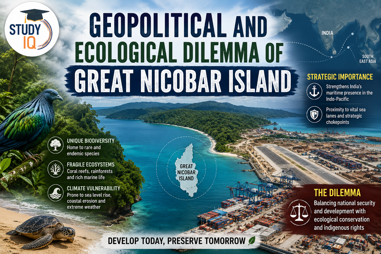
The Great Nicobar Island (GNI) project has brought one of India’s most intense developmental dilemmas to the forefront.
Read Also: UPSC Daily Current Affairs 2026
Why is Infrastructure Development on Great Nicobar Island Strategically Vital for India?
- Countering China’s ‘String of Pearls’: Developing Great Nicobar prevents a strategic security vacuum and counters Chinese naval encirclement east of Port Blair.
- g, China has secured footholds around India by investing in ports like Gwadar, Hambantota, Kyaukphyu, and Chittagong.
- Watching the Malacca Strait: A naval base at Great Nicobar places Indian surveillance right at the mouth of the world’s busiest shipping lane.
- g, Unlike INS Baaz which is too far to track Chinese submarines, GNI mirrors the forward-basing style of Diego Garcia.
- Ending Dependence on Foreign Ports: A domestic transshipment hub stops a risky commercial dependency and keeps vital shipping revenues within India.
- g, Much of India’s international cargo is currently routed through Colombo’s southern terminal, where China holds a 70-year lease.
- Fixing Past Neglect: Actively utilizing Great Nicobar’s strategic geography corrects decades of administrative neglect that turned a natural asset into a vulnerability.
- g, Admiral Arun Prakash called this a “failure of strategic imagination,” a gap exposed during the under-resourced 2004 tsunami response.
Why Does the Great Nicobar Island Project Pose a Threat to Ecological Sustainability?
- Permanent Loss to a Biodiversity Hotspot: Planting replacement trees far away in landlocked states like Haryana or Madhya Pradesh cannot bring back Nicobar’s unique tropical plants and wildlife.
- Threat to Leatherback Turtle Breeding Grounds: Building a deep-water port directly over the Galathea Bay nesting grounds violates the Convention on Biological Diversity (CBD) and India’s own Marine Turtle Action Plan.
- Displacing the Shompen Tribe: Forcing displacement on the Shompen tribe without obtaining genuine Free, Prior, and Informed Consent (FPIC) violates the Forest Rights Act of 2006
- In the 2013 Niyamgiri case, the Supreme Court ruled that tribal councils have the final say over their forests.
- Flawed Environmental Studies: The project’s environmental report is weak because it only looked at a single season, completely ignoring monsoon wildlife and migrating species.
- High Earthquake and Tsunami Risk (Zone V): Building heavy concrete structures on a volatile, disaster-prone coast without climate-proof designs risks wasting billions of rupees if a disaster hits.
How to Balance National Security and the Environment?
- Redesign the Port’s Location: Hire experts to alter the layout of the port so India gets its deep-water naval capacity without destroying Galathea Bay.
- g, : Oman moved its Duqm port 3 kilometers away from turtle nesting zones after marine surveys.
- Demand a Thorough 2-Year Environmental Study: Order a fresh, independent environmental review that spans all seasons and is led by wildlife experts.
- g, Australia’s EPBC Act mandates Strategic Environmental Assessments for projects of national significance.
- Make the Shompen Tribe Guardians of the Forest: Treat local indigenous communities as legal partners and protectors of the island rather than treating their consent as a bureaucratic checkbox.
- g., Colombia’s Atrato River judgment (2016) granted the river legal personhood and established indigenous communities as its custodians.
- Build a Nature-First Eco-Military Base: Construct the naval base to be net-zero by using solar or hydrogen power, turtle-friendly dark-sky lighting, and zero-waste systems.
- g., HMAS Stirling in Australia runs on 70% renewable energy
- Keep Environmental Adjustments Local: Ensure that any tree-planting or habitat restoration happens right within the Andaman and Nicobar islands, backed by public data tracking.
- g.,Costa Rica’s National Biodiversity Institute publishes real-time deforestation and compensation data as a governance standard.
|
Prelims Fact Box- Great Nicobar Island |
| 1. Houses Indira Point, India’s southernmost territory, located at 6°45′ N latitude.
2. Positioned 45 km north of the Six Degree Channel, a vital global shipping lane separating India from Sumatra, Indonesia. 3. Located roughly 90 km from Sumatra and near the western entry of the Malacca Strait. 4. Geography: Formed as part of the continuous submarine mountain range extending from the Arakan Yoma (Myanmar) to Sumatra. 5. Rivers: Galathea, Alexandra, Amrit Kaur, Dogmar, and Jubilee. 6. Climate Type: Equatorial/Tropical Monsoon climate 7. Biosphere Reserve: Great Nicobar Biosphere Reservewhich contains Galathea and Campbell Bay National Parks. 8. Endemic Fauna: Nicobar Megapode and the Nicobar Crab-eating Macaque. 9. Legal Safeguards: Protected under the Fifth Schedule configurations, Forest Rights Act (2006), and the Andaman and Nicobar Islands (Protection of Aboriginal Tribes) Regulation. 10. Monitored under the Andaman and Nicobar Command (ANC) at Port Blair, India’s only operational tri-services theater command. 11. Anchored by INS Baaz (naval air station at Campbell Bay) 12. Acts as the primary staging area for the tri-services joint amphibious exercise: Exercise KAVACH. |
|
Read More Notes |
|
| Environment Notes | Art and Culture Notes |
| Science and Tech | History Notes |
| Geography Notes | Indian Polity Notes |
| General Knowledge | International Relation |
|
Explore StudyIQ Courses |
|
 Commercialisation of Space: India’s Pr...
 National Investment Policy for Urea 2026...
 India’s Textile Industry: Global Chall...