Table of Contents
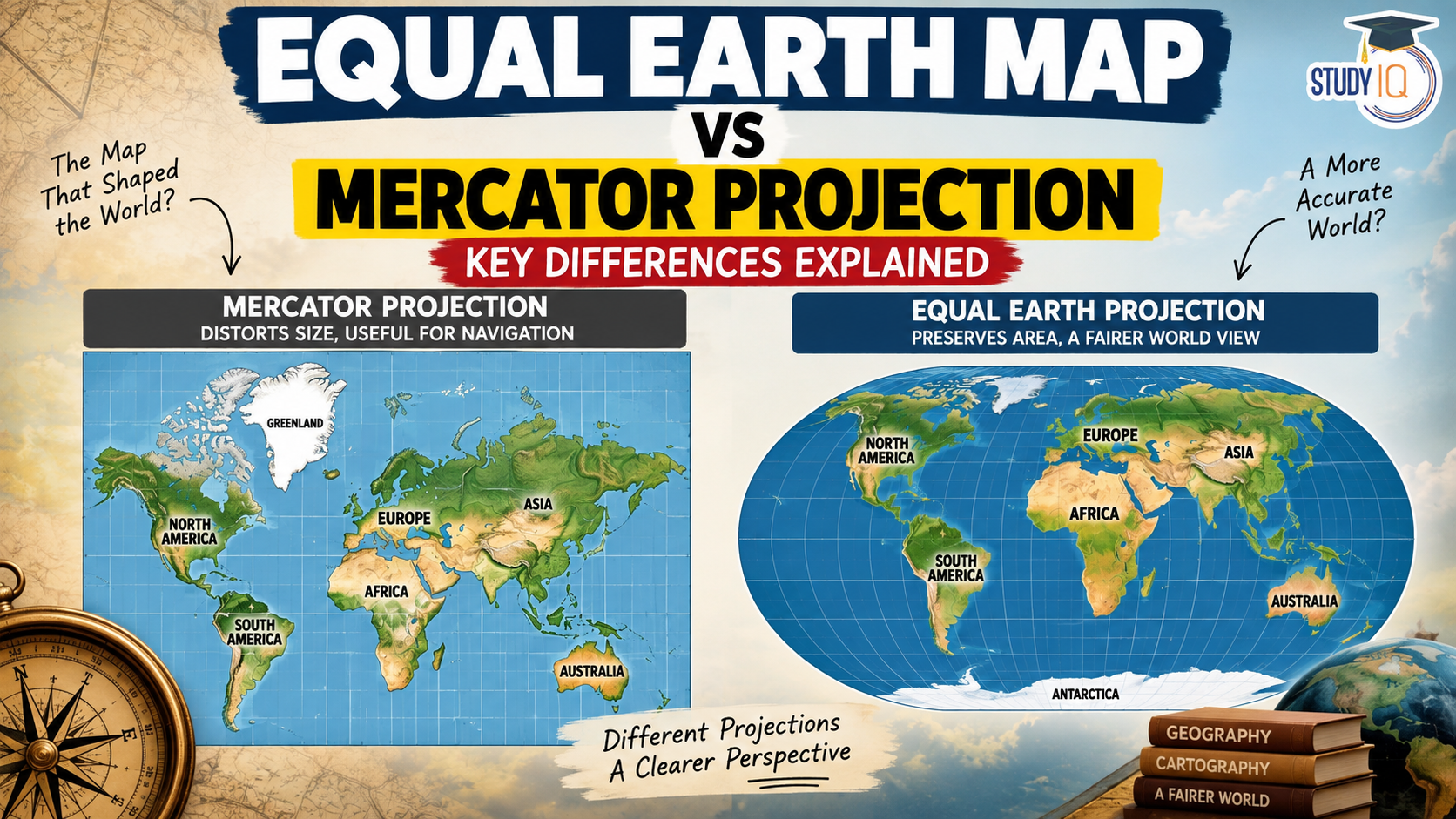
Equal Earth Map vs Mercator Projection is an important topic in geography and cartography. While the Mercator projection is widely known for its usefulness in navigation, the Equal Earth projection offers a more accurate representation of the relative size of continents and countries. The debate has gained renewed attention following the United Nations General Assembly’s support for greater use of Equal Earth-style equal-area mapping.
Read Also: UPSC Daily Current Affairs 2026
What Is a Map Projection?
A map projection is a mathematical method of representing the Earth’s three-dimensional, curved surface on a two-dimensional map.
Because the Earth is approximately spherical or spheroidal, transferring it onto a flat surface inevitably creates some distortion. A map projection may distort:
- Area – the relative size of regions
- Shape – the appearance of landmasses
- Distance – the space between locations
- Direction – compass bearings
Therefore, no single flat map can preserve all geographical properties perfectly.
What Is the Mercator Projection?
The Mercator projection was developed by Flemish cartographer Gerardus Mercator in 1569.
It is a cylindrical conformal projection, meaning it preserves local angles and shapes relatively well. Its greatest advantage is navigation because rhumb lines, or lines of constant compass bearing, appear as straight lines.
Key Features of Mercator
- Developed in 1569
- Cylindrical projection
- Conformal projection
- Preserves local angles
- Useful for marine navigation
- Has severe area distortion towards the poles
However, the Mercator projection makes regions at high latitudes appear much larger than they actually are.
Why Does Mercator Distort Size?
On a Mercator map, the spacing between parallels increases as latitude increases. This stretching is necessary to maintain angles and local shapes.
As a result, areas near the poles are greatly enlarged.
For example:
Africa vs Greenland
- Africa is approximately 14 times larger than Greenland.
- Yet Greenland can appear almost comparable to Africa on a Mercator world map.
Similarly, Antarctica appears enormously enlarged.
This does not mean Mercator is an inaccurate map in every sense. Rather, it is not designed to preserve area.
What Is the Equal Earth Projection?
The Equal Earth projection was introduced in 2018 by cartographers Bojan Šavrič, Tom Patterson and Bernhard Jenny.
It is an equal-area pseudocylindrical projection designed to represent the relative sizes of continents and countries more accurately while maintaining a visually balanced world map.
Unlike Mercator, Equal Earth prioritises area accuracy rather than conformality.
Key Features of Equal Earth
- Introduced in 2018
- Equal-area projection
- Preserves relative areas
- Curved meridians
- Reduces polar size distortion
- Useful for thematic and statistical maps
- Better suited for comparing the size of continents


Equal Earth Map vs Mercator Projection
| Feature | Mercator Projection | Equal Earth Projection |
|---|---|---|
| Developed | 1569 | 2018 |
| Projection type | Cylindrical | Pseudocylindrical |
| Main property preserved | Angles/local shape | Area |
| Area accuracy | Low, especially near poles | High |
| Shape | Relatively accurate locally | Some distortion |
| Navigation | Excellent | Not designed for navigation |
| Polar distortion | Very high | Much lower |
| Continental size comparison | Poor | Excellent |
| Major application | Navigation | Thematic/statistical mapping |
Why Is Equal Earth Important?
The importance of Equal Earth lies in how geographical information is perceived.
Traditional Mercator maps can make countries and regions closer to the poles appear disproportionately large. Equal Earth corrects this particular problem by preserving relative area.
This is particularly useful when maps are used to show:
- Population distribution
- Climate change
- Agricultural land
- Natural resources
- Deforestation
- Economic indicators
- Biodiversity
- Global inequality
For such applications, comparing the actual size of geographical regions is often more important than preserving navigation-friendly angles.
Is Mercator a “Bad” Map?
No.
This is an important point for understanding the map-projection debate.
Mercator is highly useful for navigation because it allows constant compass bearings to be represented as straight lines.
The problem arises when it is used as a general-purpose world map and viewers interpret its apparent sizes as actual areas.
Similarly, Equal Earth is not a perfect replacement for Mercator. It sacrifices some shape and distance accuracy to preserve area.
The best projection depends on the purpose of the map.
Why Is the Debate Also Political?
Map projections can influence how people visually perceive the world.
The Mercator projection has been criticised for making Europe and other high-latitude regions appear disproportionately large while reducing the apparent size of tropical regions, particularly parts of Africa and South America.
This has generated arguments about a Eurocentric or colonial visual representation of the world.
However, the historical reason for Mercator’s development was primarily navigation, rather than an explicit attempt to promote European political power.
Therefore, the debate should distinguish between the technical purpose of a projection and its later cultural or political effects.
Equal Earth and the UN
The recent UN discussion has brought renewed attention to the question of how the world should be represented on maps.
The underlying principle is not that one projection should replace every other projection. Instead, different projections should be used according to their purpose.
For example:
- Navigation → Mercator
- Area comparison → Equal Earth
- General world maps → Robinson/Winkel Tripel
- Polar mapping → Azimuthal projections
Thus, the Equal Earth debate is ultimately about choosing the right cartographic tool for the right purpose.

 India-China Border Tensions 2026: LAC, I...
 Career247 Rebrands as Adda247 Skills to ...
 GRAP Stage I Explained: AQI Limits, Meas...











 WhatsApp