Table of Contents
India’s biogeographic classification is a division of the country based on biogeographic characteristics. India has a rich heritage of natural diversity. Among the top 17 megadiverse countries in the world, India ranks fourth in Asia and tenth globally. The study of the distribution of species, organisms, and ecosystems in geographical space and over geological time is known as biogeography. India has ten biogeographical zones.
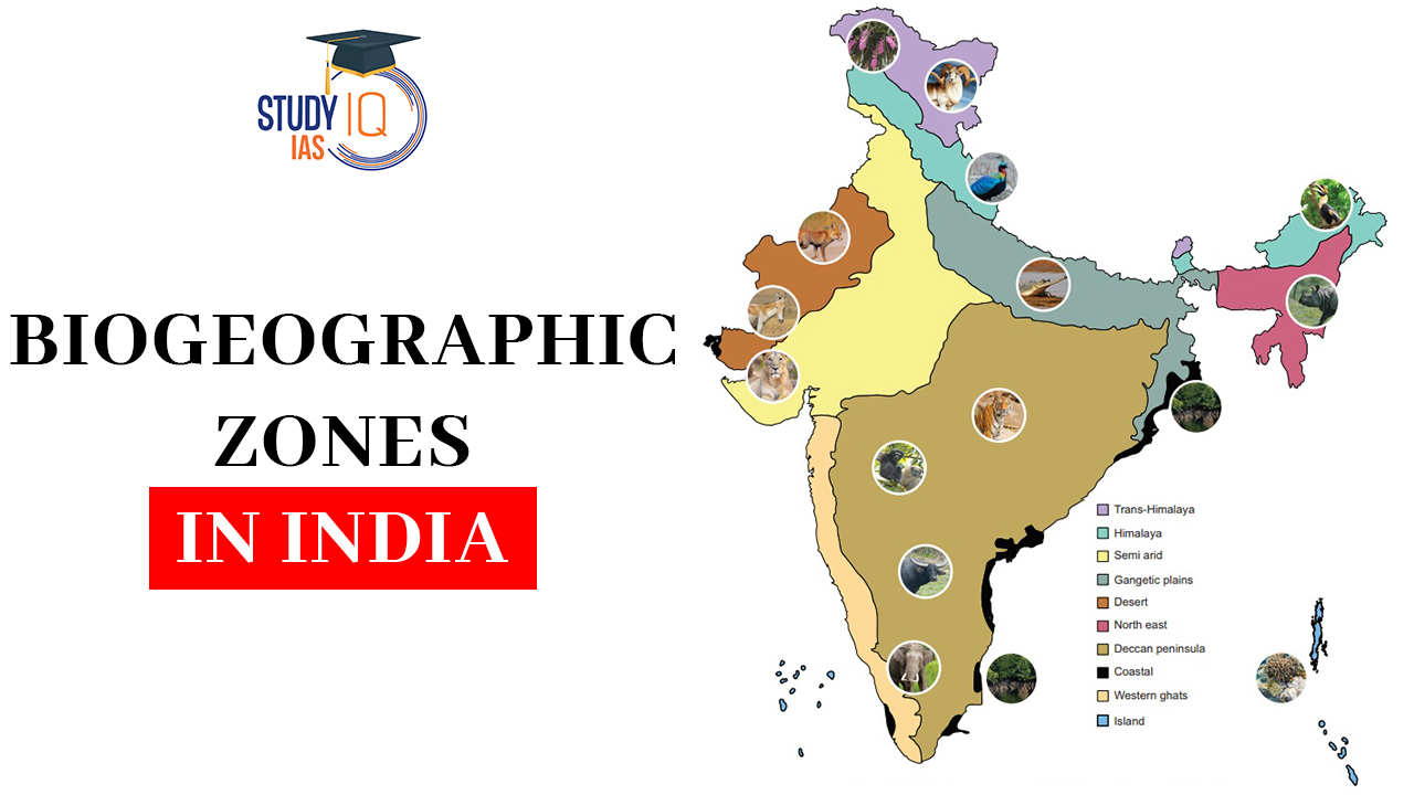
India is a megadiverse country. With only 2.4 per cent of the total land area of the world, the known biological diversity of India contributes 8 per cent to the known global biological diversity. In terms of Biogeography, India has been divided into 10 biogeographic zones as shown in the map below:
List of Biogeographic Zones in India
The List of Biogeographic Zones in India has been discussed below:
| List of Biogeographic Zones in India | ||
| Name of the Zone | Total Area | Percentage |
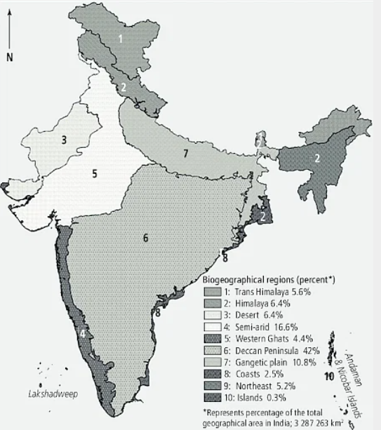
| Trans-Himalayan Region | 184823 | 5.62% |
| Himalayan Zone | 210662 | 6.41% |
| Indian Desert Zone | 215757 | 6.56% |
| Semi-arid Zone | 545950 | 16.60% |
| Western Ghats | 132606 | 4.03% |
| Deccan Plateau | 1380380 | 41.99% |
| Gangetic Plain | 354782 | 10.79% |
| North East Region | 82813 | 2.52% |
| Islands | 171341 | 5.21% |
| Coastal Region | 8249 | 0.25% |
| Total | 3287263 | 100% |
About Biogeographic Zones in India
India is one of the 17 megadiverse nations of the world with an amazing diversity of ecosystems, climates, and species. To comprehend and conserve this rich biodiversity successfully, India has been roughly subdivided into 10 distinctive biogeographic zones. This division was largely carried out by Rodgers and Panwar of the Wildlife Institute of India (WII) in 1988 for conservation planning reasons. Every Biogeographic Zones in India is marked by its distinct geographical conditions, climate, and the typical flora and fauna adapted to living within it.
Trans-Himalayan Region
- It comprises the high-altitude, chilly, and arid mountain regions of Himachal Pradesh’s Ladakh, Jammu and Kashmir, North Sikkim, Lahaul, and Spiti regions, making up 5.6% of the country’s total land area.
- The world’s largest populations of wild sheep and goats, as well as other uncommon wildlife like the Snow Leopard and the migratory Black-necked Crane (Grus nigricollis), may all be found in this area, which has limited alpine steppe flora that supports several endemic species.
- An exceptionally sensitive ecosystem exists in the cold, arid desert of this region.
Himalayan Zone
- It contains some of the highest peaks on the globe and makes up 6.4% of the entire geographic area.
- India is one of the regions with the greatest diversity of habitats and species due to the Himalayan region.
- Himalayas in the east, northwest, west, and centre
- The grassy meadows, moist mixed deciduous forests, and alpine and subalpine forests offer a variety of habitats for endangered bovid species such as the Himalayan Tahr (Hemitragus jemlabicus), Bharal (Pseudois nayaur), Ibex (Capra ibex), Markhor (Capra falconeri), and Takin (Budorcas taxicolor).
- The Hangul (Cervus eldi eldi) and Musk Deer (Moschus moschiferus) are two other uncommon and endangered species that are endemic to this area.
Indian Desert Zone
- It is the severely dry area west of the Aravalli mountain range, which contains both the saltwater desert of Gujarat and the sand desert of Rajasthan.
- The Indian desert, which mostly includes Rajasthan’s western and northwestern parts as well as a portion of Gujarat’s Kachchh region in the southwest, marks India’s northern border.
- At the Aravalli range in the east, it is 350–450 meters above sea level; in the south and west, it is 100 meters; and in the Rann of Kachchh, it is 20 meters.
- Numerous endangered mammal species, including the wolf (Canis lupus), caracal (Felis caracal), desert cat (Felis libyca), and birds of conservation concern, such as the houbara bustard (Chlamydotis undulate) and the great indian bustard (Ardeotis nigriceps), can be found there in huge tracts of grassland.
Semi-arid Zone
- 16.6% of the overall geographic area that is made up of the semi-arid region serves as a transitional area between the desert and the Western Ghats‘ lush forests.
- There are two sizable semi-arid zones in peninsular India. Along with numerous man-made and natural lakes, this semi-arid region also features marshy areas.
- The highest wildlife biomass is found in this zone’s main grass and palatable shrub layer.
- The region is characterised by irregular vegetation covered in barren soil, as well as a constant lack of soil water.
- The Punjab plains, Delhi, Haryana, the western margins of Himachal Pradesh, Jammu and Kashmir, eastern Rajasthan, eastern Gujarat, and northwest Madhya Pradesh are all included in this region.
- The semi-arid zone in Western India is distinguished by savannah woodland, dry deciduous forest, and tropical thorn forest.
- The Aravalli System, located in the centre of this region, is home to two different plant species: tropical dry deciduous forest and tropical thorn forest.
- Sambar (Cervus unicolour) and Chital (Axis axis) are two cervid species that are only found in better-wooded hills and moister valley regions, respectively.
- One of the endangered species present in this area is the lion (Leo persica), a carnivorous species that is only found in a tiny area of Gujarat. Other endangered species include the caracal (Felis caracal), jackal (Canis aureus), and wolf (Canis lupus).
Western Ghats
- Western Ghats account for 4% of the total geographical area. It is one of two “hotspots” for biodiversity and one of India’s key tropical evergreen forest zones.
- From the Tapti River in the north to Kanyakumari in the south, the Western Ghats run along the west coast of peninsular India, spanning through the states of Gujarat, Maharashtra, Goa, Karnataka, Tamil Nadu, and Kerala.
- One of India’s largest tropical evergreen forested regions and one of the world’s 25 biodiversity “hotspots” with a vast array of plant species is the Western Ghats zone.
- Nearly 4000 types of blooming plants may be found in the area, which makes up nearly 27% of all the flora in India. There are 1500 indigenous species among them.
- With a wide variety of ancient lineages, the Western Ghats region is an important genetic resource.
- The majority of the vertebrate species found in peninsular India have living populations in the Western Ghats, along with an endemic faunal component.
- The Malabar Grey Hornbill (Ocycerous griseus), Nilgiri Tahr (Hemitragus bylocrius), Grizzled Giant Squirrel (Ratufa macroura), Lion Tailed Macaque (Macaca silenus), and Nilgiri Langur (Presbytis jobni) are all native to this area.
- Only a small portion of the Western Ghats is home to the endangered Travancore Tortoise (Indotestudo forsteni) and Cane Turtle (Heosemys silvatica).
Deccan Plateau
- The Deccan Plateau, which makes up 42% of the country’s total land area, is its greatest biogeographic zone.
- It is a semi-arid area that is under the Western Ghats’ rain shadow.
- The region is rather uniform, with climates ranging from moist-deciduous/semi-evergreen to semi-arid.
- The best forests in India are found in this biogeographic region, which is by far the largest and includes the states of Madhya Pradesh, Maharashtra, and Odisha.
- The central highlands include the Vindhya and Satpura hill ranges, the Chhota Nagpur Plateau, the Eastern Ghats, the Tamil Nadu Plains, and the Karnataka Plateau. The varied flora of the Vindhya and Satpura hill ranges is well known.
- Although deciduous forests predominate, there are regions with more ecological diversity in the hill ranges. Numerous wildlife species can be found in the area, which is made up of degraded scrubland, thorn woods, and deciduous forests.
- This area is home to the following species
- Barking deer (Muntiacus muntjak), Sambar (Cervus unicolour), Nilgai (Boselapbus tragocamelus), Chital (Axis axis), Gaur (Antilope cervicapra), and Elephant (Elephas maximus) are all found in the Bihar-Orissa and Karnataka-Tamil Nadu regions.
- A small area between the borders of Orissa, Madhya Pradesh, and Maharashtra is home to wild buffalo (Bubalus bubalis).
- Cervus duvauceli, often known as the Hard Ground Swamp Deer, is currently confined to a single area in Madhya Pradesh.
Gangetic Plain
- About 10.8% of the world’s land area is made up of the Gangetic plain. Over several miles, the Gangetic plain is topographically uniform.
- This zone includes the Gangetic split as well as the Upper Gangetic plain, Middle Gangetic plain, and Lower Gangetic plain.
- The majority of the land is used for agriculture, and there are many people living in this area, which runs from eastern Rajasthan through Uttar Pradesh to Bihar and West Bengal.
- The Terai-Bhabar regions of Uttar Pradesh, Bihar, and West Bengal are included in the Gangetic plain.
- Some of the largest population densities and topographic regularity can be found in the teak, shisham, sal, khair, and other trees from these forests.
- The Rhinoceros unicornis, Elephant (Elephas maximus), Buffalo (Bubalus bubalis), Swamp Deer (Cervus duvauceli), and Hog-Deer (Axis porcinus) are among the species of this area.
North East Region
- The North East Region accounts for 5.2 per cent of the total geographical area.
- This area serves as a meeting place for the Himalayan Mountains and peninsular India, as well as a transition zone between the Indian, Indo-Malayan, and Indo-Chinese biogeographical areas.
- Thus, the North-East serves as both a biodiversity hotspot (the Eastern Himalaya) and a biogeographical “gateway” for much of India’s flora and wildlife.
- Many of the species that make up this biological diversity are either unique to the Khasi Hills as a whole or to certain localised locations within the region.
Islands
- This zone is one of the three tropical moist evergreen forest zones and makes up about 0.3% of India’s total land area.
- Unique plants and animals can be found on the islands. These islands contain some of India’s best evergreen forests, a wide variety of corals, and high-endemism hotspots.
- The Lakshadweep Islands and the Andaman Islands make up the two main groups of islands.
- A collection of 27 tiny islands known as the Lakshadweep Islands can be found in the Arabian Sea. Their distance from Kerala’s shore is 320 kilometres.
- The Andaman and Nicobar Islands are a 348-island group that extends north-south in the Bay of Bengal.
- The distance between Cape Negrais in Burma and the Andaman Islands is around 190 kilometres.
- The five islands that make up the 300 km long Great Andaman are situated near one another, with the Little Andaman to the south. 800 m-deep canals are separating the Nicobar island groupings from the Andaman and from one another.
- The only endemic island biodiversity in India is found on the Andaman and Nicobar Islands. The Narcondam hornbill and the South Andaman krait are two examples of the indigenous wildlife of the Andaman and Nicobar Islands.
Coastal Region
- India’s wealth and health zone is the coastal region, which makes up about 2.5 per cent of the country’s total land area and is home to sandy beaches, mangroves, mud flats, coral reefs, and marine angiosperm pastures.
- There are 5,423 kilometres of shoreline between Gujarat and the Sunderbans, according to estimates.
- The Lakshadweep is composed of 25 coral islets and features a typical reef lagoon system with a diverse range of wildlife. However, there is almost no natural vegetation on the crowded Lakshadweep islands.
Challenges of Biogeographic Zones of India
Here are the key challenges faced by the Biogeographic Zones of India:
- Changes in Climatic Conditions
- Drying up of rivers and aquifers
- Loss of Species and Biomass
- Desertification
- Rapid melting of glaciers
- Floods and Droughts
Key Problems
- Deforestation and Loss of Habitat: Due to logging, agriculture, urbanization, and infrastructure development.
- Poaching and Wildlife Trade: Endangers tigers, elephants, and pangolins in various regions.
- Invasive Alien Species: Exotic plants and animals interfere with indigenous biodiversity (e.g., Lantana, Parthenium).
- Climate Change: Changes temperature and precipitation patterns, affecting vulnerable ecosystems such as the Himalayas and coastal areas.
- Pollution: Industries and agriculture discharge air, water, and soil pollutants that impact biodiversity and ecological equilibrium.
- Human-Wildlife Conflict: Spread to forest regions causes repeated conflict, particularly in the Deccan Peninsula and Himalayan regions.
- Overgrazing: Destroys grasslands and forest boundaries, particularly in arid and semi-arid regions.
- Mining and Quarrying: Causes destruction of habitats and water pollution in areas such as the Western Ghats and Central Highlands.
- Unsustainable Tourism: Harms fragile ecosystems in areas like the Himalayas and Andaman & Nicobar Islands.
- Poor Conservation Management: Insufficient enforcement, financing, and local participation in the administration of protected areas and reserves.
 Great Indian Bustard (GIB): Features, Th...
 Seshachalam Forest: Topography, Vegetati...
 NGT Mandates Mitigation of Arsenic &...