Table of Contents
Context: Pakistan violated the ceasefire along the Line of Control in the Kashmir Valley by resorting to unprovoked firing.
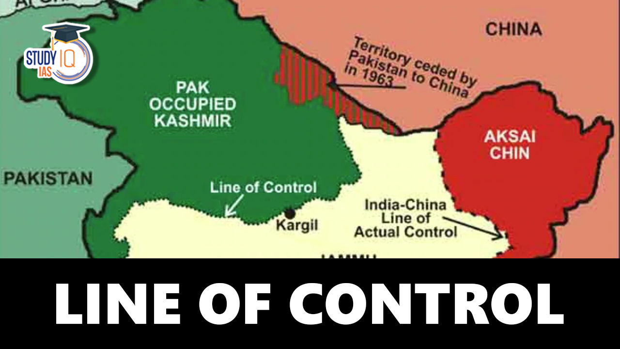
The Line of Control (LoC) is perhaps the most sensitive and unstable border in the world, dividing Indian-administered Jammu & Kashmir from Pakistan-administered areas. It is not an internationally recognised boundary, but acts as the de facto military control line between India and Pakistan. The LoC continues to be a reminder of unsettled differences between the two nuclear-armed neighbours, with repeated ceasefire violations and militant intrusions.
Following the Pahalgam terror attack in April 2025, the LoC has again been brought under sharp focus, underscoring recurring cross-border threats and the imperative for strong security measures.
Line of Control (LoC)
- Nature of the Boundary: The Line of Control (LoC) serves as the de facto military boundary between India and Pakistan in the Jammu and Kashmir region.
- Historical Background: It originated as the Ceasefire Line after the first India-Pakistan war in 1947–48 over Kashmir.
- Redesignation Post Simla Agreement: After the 1971 Indo-Pak war, the Simla Agreement signed on 3 July 1972 officially renamed the Ceasefire Line as the Line of Control.
- Length and Coverage: The LoC spans approximately 740 kilometres, running from Ladakh in the north to Poonch district in the south.
- Security and Militarization: It is a highly militarised zone, frequently witnessing cross-border firing and skirmishes between the armed forces of both nations.
- Territorial Demarcation:
- On the Indian side, it encompasses parts of Jammu and Kashmir. and Ladakh.
- On the Pakistani side, it covers Pakistan-occupied Kashmir (PoK), including Gilgit and Baltistan.
Read More: Kargil Vijay Diwas
What is the Line of Control (LoC)?
The Line of Control (LoC) is a de facto border that divides the portions of the former princely state of Jammu and Kashmir that India and Pakistan militarily control. It is not a legally recognised international border. The Simla Agreement, which put an end to the Indo-Pakistani War in 1971, included its establishment. The cease-fire line was renamed the “Line of Control” by both nations, who also promised to uphold it regardless of their respective positions. The line is essentially the same as the original 1949 cease-fire line, with a few minor modifications.
Jammu and Kashmir and Ladakh are the two union territories that make up the portion of the erstwhile princely state that is under Indian administration. Azad Kashmir and Gilgit-Baltistan are the two regions under Pakistani administration. The Siachen Glacier, which became a cause of dispute in 1984, is located beyond NJ9842, the northernmost point of the Line of Control. The border between Pakistan’s Punjab and the Jammu province is to the south of the Line of Control and has an ambiguous status; Pakistan refers to it as a “working border,” while India refers to it as an “international boundary” (Sangam, Chenab River, Akhnoor).
Read More: Amar Jawan Jyoti
Background of the Line of Control
After the partition of India, present-day India and Pakistan contested the princely state of Jammu and Kashmir – India because the ruler acceded to the country, and Pakistan because of the state’s Muslim-majority population. Before a cease-fire was negotiated through UN mediation, the First Kashmir War of 1947 raged for more than a year. A cease-fire line was agreed upon by all parties.
Only minimal changes were made to the original ceasefire line after the 1965 Kashmir War and the 1971 Indo-Pakistani War (which saw Bangladesh gain independence). Both nations agreed to turn the ceasefire line into a “Line of Control” (LoC) and observe it as a de facto border that armed conflict should not cross in the succeeding Simla Agreement in 1972.
The agreement declared that “neither side shall seek to alter it unilaterally, irrespective of mutual differences and legal interpretations”. Investigation of ceasefire violations (CFVs) was the responsibility of the United Nations Military Observer Group in India and Pakistan (UNMOGIP), although this responsibility waned after 1971. The Indian subcontinent, and the Kashmir Line of Control in particular, were mentioned as some of the most hazardous regions in the world by US President Bill Clinton in 2000.
Also Read: India-Pakistan Border Disputes
Current Situation at LOC
1. Heightened Military Alertness
In the aftermath of the Pahalgam attack, the Indian Army has intensified its vigilance along the LoC. Reports indicate increased troop deployments and surveillance activities to thwart any potential infiltration attempts by militants. The Indian Army remains on high alert, especially in sensitive sectors prone to cross-border incursions.
2. Ceasefire Violations and Infiltration Attempts
There have been multiple instances of ceasefire violations and attempted infiltrations by Pakistani troops along the LoC. Notably, on April 1, 2025, Pakistani forces attempted to intrude into the Indian side in the Krishna Ghati sector of Poonch district, which was successfully repelled by Indian troops.
3. Diplomatic Fallout
The Pahalgam attack has led to a significant deterioration in diplomatic relations between India and Pakistan. India has downgraded diplomatic ties, revoked visas for Pakistani nationals, and suspended the Indus Waters Treaty, a critical water-sharing agreement. In retaliation, Pakistan has closed its airspace to Indian airlines, suspended trade, and warned that any attempt by India to divert shared river waters would be considered an act of war.
4. Suspension of Bilateral Agreements
Pakistan has announced the suspension of all bilateral agreements with India, including the 1972 Simla Agreement, citing India’s actions as provocations. This move further exacerbates the already strained relations and raises concerns about the stability of the region.
Comparison Between LOC and LAC
Check the comparison between the Line of Control (LOC) and Line of Actual Control (LAC) in the table given below:
|
Comparison Between LOC and LAC |
|
| Line of Control (LOC) | Line of Actual Control (LAC) |
| Location: Three regions of Kashmir (i.e. Azad Kashmir, Gilgit & Baltistan) occupied by Pakistan and two-thirds, Jammu, Ladakh, and the Kashmir Valley, which is administered by India. (although the whole of Kashmir is an integral part of India) | Location: LAC is scattered in three areas of northern Indian states: eastern (Sikkim, Arunachal Pradesh), middle (Uttarakhand, Himachal Pradesh) and western (Ladakh, Kashmir). |
| LOC is clearly demarcated by the military, and a lot of activities (i.e. face to face confrontation, firings, etc) take place. The Indian and Pakistani armies are present here. | There are big empty regions, and nearly 50 to 100 km distance is maintained between the Indian & Chinese armies. |
| Length of LOC is 776 kilometres (unofficial) | Length of LAC is 4,057 kilometres (unofficial) |
| It is the border between India & Pakistan | It is the border between India & China |
 China’s Global Ocean Mapping Initiativ...
 Strait of Hormuz Crisis: Causes, Impact ...
 Political Shift in Nepal: Opportunity an...