Table of Contents
ISRO Launched PSLV-C56
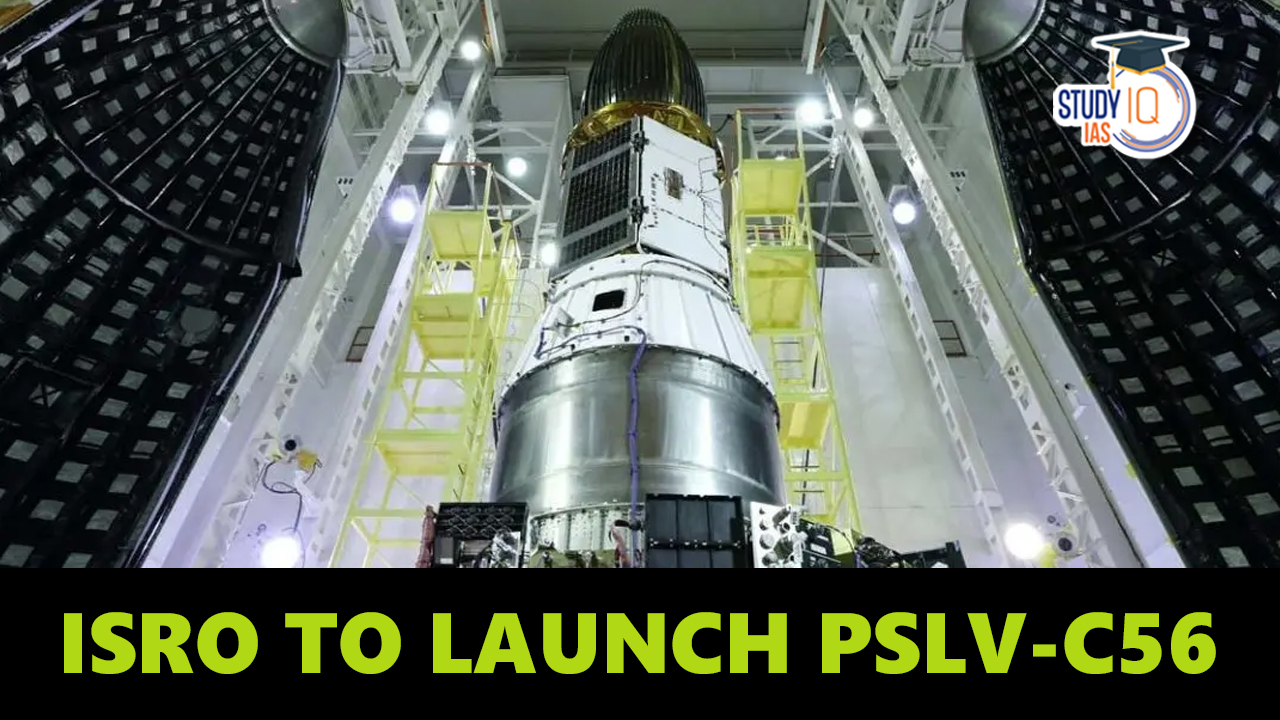
The ISRO (Indian Space Research Organisation) has been launched PSLV-C56 carrying Singapore’s DS-SAR Satellite and other 6 satellites on July 30, 2023, from Satish Dhawan Space Centre, Sriharikota. The seven satellites will be launched into near-equatorial orbit over the polar satellite launch vehicle PSLV-C56. The DS-SAR satellite, a synthetic aperture radar (SAR) spacecraft created by Singapore and Israel, is the main payload.
The six other satellites are co-passengers from different nations and organizations. Since the PSLV-C56 is set up in its core-alone configuration, its first stage does not utilize solid rocket strap-on motors. Because of this, it functions as a flexible and adaptable launch vehicle that can meet various mission needs. The Satish Dhawan Space Centre in Sriharikota, Andhra Pradesh, will serve as the launch site for the PSLV-C56.
Also Read: Chandrayaan 3 Mission
DS-SAR Satellite
The DS-SAR satellite is developed under a partnership between DSTA (representing the Government of Singapore) and ST Engineering. Once deployed and operational, it will be used to support the satellite imagery requirements of various agencies within the Government of Singapore. ST Engineering will use it for multi-modal and higher responsiveness imagery and geospatial services for their commercial customers.
- DS-SAR carries a Synthetic Aperture Radar (SAR) payload developed by Israel Aerospace Industries (IAI). This allows the DS-SAR to provide for all-weather day and night coverage and is capable of imaging at 1m resolution at full polarimetry.
- The 360 kg DS-SAR satellite uses synthetic aperture radar (SAR) to produce high-resolution photographs of the Earth’s surface in all kinds of weather and at all hours of the day.
- The National University of Singapore, DSO National Laboratories, and ST Engineering, a Singapore-based corporation, worked together to design and construct the satellite.
- The DS-SAR satellite will be launched by the PSLV-C56 rocket into a NEO, or near-equatorial orbit, at an altitude of 535 km and an inclination of 5 degrees. The satellite will be able to cover a significant portion of the equatorial region of the planet from this orbit.
Along with DS-SAR, PSLV-C56 will carry six co-passenger satellites
- VELOX-AM, a 23 kg technology demonstration microsatellite.
- ARCADE Atmospheric Coupling and Dynamics Explorer (ARCADE), an experimental satellite
- SCOOB-II , a 3U nanosatellite flying a technology demonstrator payload
- NuLIoN by NuSpace, an advanced 3U nanosatellite enabling seamless IoT connectivity in both urban & remote locations.
- Galassia-2, a 3U nanosatellite that will be orbiting at low earth orbit.
- ORB-12 STRIDER , satellite is developed under an International collaboration
What is Polar Satellite?
As the Earth revolves on its axis, polar satellites, a type of artificial satellite, travel over the poles as they circle the planet in a north-south orientation. Polar satellites may cover the whole surface of the Earth over time, unlike geostationary satellites, which maintain a stable location over the equator; this makes them ideal for a variety of tasks like mapping, weather monitoring, reconnaissance, and communication.
Low Earth orbit (LEO) for polar satellites is typically 500–800 km above the surface of the planet. They have cameras and sensors that can record many kinds of data, including data from radar, magnetometers, microwaves, and visible and infrared light. Some polar satellites also include reaction wheels or thrusters to regulate their height and orientation.
Applications of Polar satellites
- High-resolution maps of the topography, land use, vegetation, water resources, and natural disasters can be produced using polar satellites. They can also keep track of environmental changes over time, like logging, urbanization, glacier melting, and sea level rise.
- Polar satellites can measure a variety of climatic and meteorological variables, including cloud cover, precipitation, radiation, temperature, humidity, pressure, and wind speed. Additionally, they can track storms and cyclones and offer early warning systems for environmental dangers.
- For military and security needs, polar satellites can gather intelligence and surveillance information. They can keep an eye out for enemy troop movements, missile launches, nuclear tests, and the development of weaponry. For military activities, they can also help with communication and navigation.
Polar Satellite Launch Vehicle (PSLV)
- An impressive feat of Indian space technology is PSLV. It is a flexible and dependable rocket that can put different kinds of satellites into varied orbits. Its four stages alternate between solid and liquid propellants.
- Indian Remote Sensing (IRS) satellites are to be launched using PSLV into polar sun-synchronous orbits as its primary goal. These satellites are used for a variety of purposes, including resource mapping, disaster management, and earth observation.
- Additionally, PSLV has shown that it is capable of launching numerous satellites on a single mission and of inserting satellites into geostationary and extraterrestrial orbits.
Most Notable Missions of PSLV
- Chandrayaan-1: India’s first lunar mission, Chandrayaan-1, was launched in 2008. It was equipped with an orbiter and an impactor that travelled to the moon successfully and carried out research.
- Mars Orbiter project (MOM): India’s first interplanetary project, the Mars Orbiter project (MOM), was launched in 2013. It was equipped with a spacecraft that entered Mars’ orbit and carried out numerous investigations of the planet’s atmosphere and surface.
- Astrosat Mission: launched in 2015, it was India’s first observatory in orbit. It carried a collection of tools for observing the cosmos at various wavelengths, including X-ray, ultraviolet, and visible light.
- Cartosat-2 series: A constellation of high-resolution earth imaging satellites called the Cartosat-2 series. They offer information for applications including cartography, city planning, coastal land use, rural development, and other things.
- RISAT series: A group of radar imaging satellites known as the RISAT series. They provide daytime and nighttime surface monitoring in all weather conditions.
 UPSC CMS Admit Card 2026 Out, Download H...
 UPSC Principal and Vice Principal Recrui...
 Lokmanya Tilak Jayanti 2026: Biography, ...