Table of Contents
Context: India has summarily rejected China’s attempt to lay claim over areas of Arunachal Pradesh after it issued new official names for them.
More on the News
- China’s Ministry of Civil Affairs on Sunday had released the standardized names of 11 places for Arunachal Pradesh, which it calls “Zangnan, the southern part of Tibet”.
- This is the third batch of standardized geographical names for Arunachal Pradesh issued by China’s civil affairs ministry.
- The first set of names was announced by China in 2017 days after the Dalai Lama’s visit to Arunachal Pradesh. And the second batch of 15 places was issued in 2021.
- Possible factors behind the latest move by China:
- One factor could be China’s retaliation against India’s decision to hold a G-20 engagement group meeting on Innovation technology in Itanagar, which the Chinese embassy had boycotted.
- Additionally, China’s recent move may be a response to India’s decision to rebuff a PLA attempt to take over a post at Yangtse in the Tawang sector of the Line of Actual Control (LAC) in December 2022.
What is China’s argument for claiming the areas in Arunachal Pradesh?
- Dispute over the legality of the McMahon Line: China disputes the legality of the McMahon Line, which was agreed upon at the Simla Convention of 1914 between Tibet and British India.
- China claims that Tibet had no authority to enter into international agreements and, therefore, did not give its consent to the convention.
- Historical ties: China also bases its claims on the historical ties that have existed between the monasteries in Tawang and Lhasa. China claims that Tawang was historically part of Tibet and, therefore, falls under its jurisdiction.
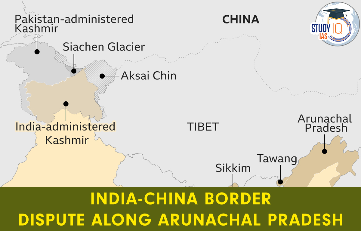
An Overview of India-China Border
- India shares total boundary of around 3,488 km with China (second largest after Bangladesh).
- The Sino-Indian border is generally divided into three sectors namely: Western sector, Middle sector, and Eastern sector.
| Western Sector | India shares a boundary of about 2152 km with China in the western sector.
It lies between Jammu and Kashmir and Xinjiang, and Aksai Chin is the disputed territory of this region. The dispute of Aksai Chin can be dated back to the failure of the Colonial Empire failing to demarcate the clear border between India and China. At present, LAC (Line of Actual Control) is the border line separating Indian areas of Jammu & Kashmir from Aksai Chin which is concurrent to the Chinese-claimed Aksai Chin. |
| Middle Sector | It is about a 625km long boundary, it is the only sector where both countries have fewer disagreements, and it borders Ladakh and Nepal.
The border of Uttarakhand and Himachal Pradesh touches the border of Chinese occupied region of Tibet. |
| Eastern Sector | It is an 1140 km long boundary with China that extends from eastern Bhutan to the Talu Pass over the Tri-junction of Tibet, India and Myanmar.
This boundary line is named as McMahon Line. China considers the McMahon line illegal. |
What is the Importance of Arunachal Pradesh from an Indian/Chinese Perspective?
- Indian perspective:
- Arunachal Pradesh is strategically significant due to its location and its importance as a buffer state between India and China.
- It serves as a protective shield to India’s northeast and provides a critical strategic depth to India’s military defences.
- Chinese perspective:
- From a Chinese perspective, Arunachal Pradesh is important due to its strategic location, natural resources, and its potential as a gateway to Southeast Asia.
- Additionally, Arunachal Pradesh holds significant hydro-power potential. China’s control over India’s water supply to the north-eastern region gives it the ability to use water as a geostrategic weapon against India by causing flooding or drought in the region.
 Santa Marta TAFF Conference 2026: Key Hi...
 International Firefighters Day 2026: His...
 Tamil Nadu Election Results 2026 LIVE: T...