Table of Contents
Context: 3 hyperspectral satellites developed by Indian startup Pixxel were recently launched by SpaceX Falcon-9. With this, Pixxel has completed Phase 1 of its Firefly Constellation, placing a total of six satellites in orbit.
What is Meant by Hyper-Spectral Imaging Satellite
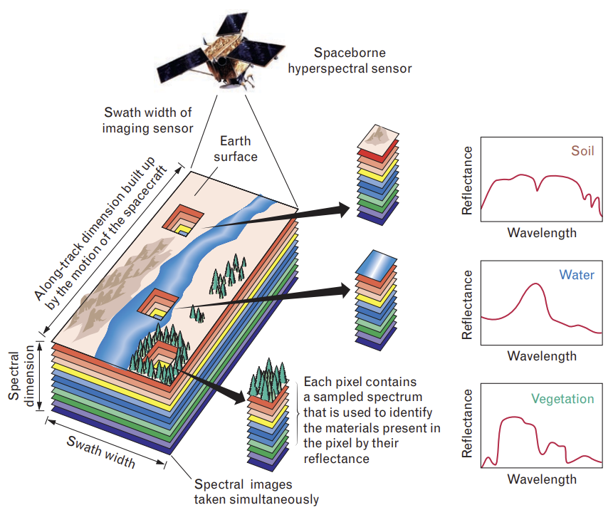
- A hyperspectral imaging (HSI) satellite is an Earth observation satellite that captures images across dozens to hundreds of narrow spectral bands (from visible to short-wave infrared), instead of just a few bands (as in RGB or multispectral imaging).
- It provides a detailed spectral signature for every pixel on Earth’s surface, enabling precise detection of materials, gases, crops, or minerals.
Key Features
- Spectral Bands: Captures data in 37 to 100+ bands (vs 3 in RGB, 4–12 in multispectral).
- High Resolution: Up to 5-metre resolution (Pixxel’s Firefly).
- Spectral Range: Covers visible (400 nm) to short-wave infrared (~2500 nm).
- Data Richness: Each pixel contains a continuous reflectance spectrum, enabling chemical & physical property analysis.
- Constellation Advantage: Multiple satellites provide frequent global coverage (Pixxel → 24 hrs with 6 satellites).
| Multispectral Imaging |
|
About Firefly Constellation
- Firefly is Pixxel’s flagship hyperspectral imaging satellite constellation, featuring six of the highest-resolution commercial hyperspectral satellites.
- Satellites are designed to deliver critical climate and Earth insights with unmatched precision.
- A satellite constellation is a network of identical artificial satellites with the same purpose and shared control, designed to work as a system.

| Related Information |
|


 Advanced Air Defence Radars: Types, Comp...
 Ion Chromatography, Working and Applicat...
 Broadly Neutralising Antibodies (bNAbs):...


