Table of Contents
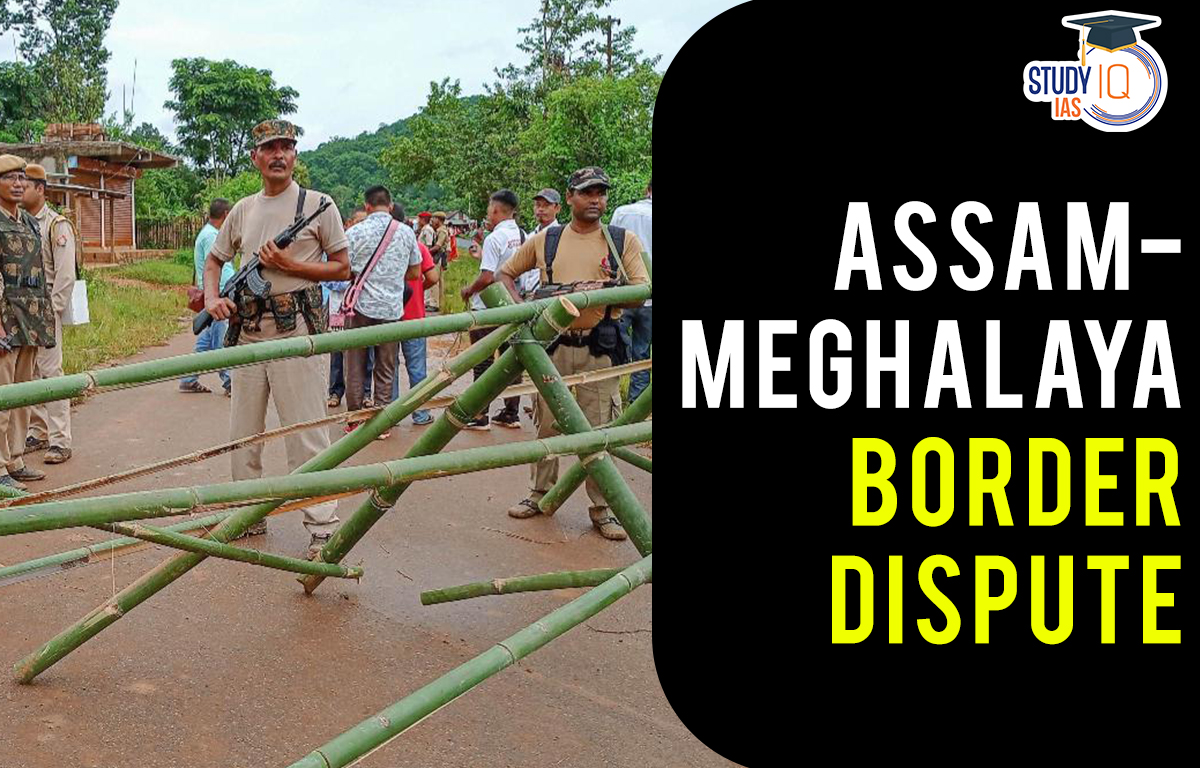
Context: Recently there has been a dispute between the Governments of Assam and Meghalaya over the ownership of Mukroh village.
Inter State Border Disputes in India
- A Challenge in India: India has faced several challenges like merger of princely states, curbing secessionist sentiments, establishing democratic institutions and most importantly reorganizing states on amicable parameters.
- State Reorganization Act, 1956: The State Reorganization Act, 1956, demarcated the boundaries on the grounds of language, administrative convenience and other factors.
- Later with more regions getting statehood, various border disputes started arising which are unresolved till date.
- These disputes sometimes become a challenge to fraternity and harmony in the country.
- Assam-Meghalaya Dispute: As most of the North-Eastern States were part of Assam itself prior to reorganization, Assam has border disputes with almost all these States.
- Meghalaya was carved out of Assam as an autonomous State in 1972 and became a full-fledged state in 1972.
- Till now, Meghalaya and Assam had disputes over 12 areas but in 2022 they signed a historic agreement which resolved disputes over six areas.
What are the Causes of Inter-State Border Disputes in India?
- Colonial Records: The continued use of British records and notifications for demarcating the boundaries has resulted in disputes.
- The British had demarcated boundaries unilaterally and for their own administrative convenience without taking into account local demands and needs.
- Parameters of Re-organisation: Several border disputes have their roots in State reorganization of the 1950s which was primarily on the basis of language. State’s identity was linked with language.
- For instance, dispute between Karnataka and Kerala over Kasargod where people speaking Kannada reside.
- Also, most of the demarcation took place based on colonial cartographies without taking into account the village boundaries and socio-cultural liminality.
- Competition for Resources: As resources are limited, especially in States with difficult terrain and geography, they get indulged in disputes to have maximum gains.
- For instance, Himachal Pradesh and UT of Ladakh have disputes over Sarchu, which has a huge tourism potential.
- Regionalism: Regionalism based on ethnicity, language etc. is a driving force for such inter -state disputes.
- For instance, Nagaland claims all Naga dominated areas in north Cachar.
- Opportunism of Political Parties: It has been alleged that some disputes have political motives behind them because they usually come up during elections.
- So instead of finding a resolution for the border dispute, the political parties use them as a tool to mobilize people and expand their vote bank.
- Such opportunistic behaviour has resulted in perpetuating the issue rather than its resolution.
- Geographical Factors: Sometimes geography also plays a role in disputes, as it is difficult to demarcate boundaries with rivers changing courses, hills etc.
- For instance, Uttar Pradesh and Bihar have disputes due to the course change of river Ganga.
- Ineffective Use of Constitutional and Statutory Mechanisms: Article 263 of Indian Constitution provides for creation of Inter-state council to serve as platform to resolve disputes among Union and States as well as between the States.
- The State Re-organisation Act, 1956 has established Zonal councils to facilitate dialogues.
- However, these mechanisms have not been explored well by states concerned.
What is the Impact of Inter-State Border Disputes?
- Trust Deficit: Border disputes always come with instability, trust deficit and are detrimental to the overall social fabric of the society.
- Rise of Secessionist Tendencies: Border disputes if remain unresolved for a long period of time can result in growing feelings of secession among people which pose a great threat to unity and territorial integrity of the country.
- Violence Clashes: Clashes over border disputes sometimes become violent which can result in loss of life and property.
- Lack of Development in Disputed Regions: As disputed areas become politically fragile and unstable, economic and infrastructure development in such areas get hampered which ultimately affects the local population residing there.
- Spillover Effect: Unresolved border disputes at many times have spillover effects on other issues between States like interstate water disputes, migration etc. which can possibly result in more disputes.
- Loss of faith in Law and Order Machinery: Violence and instability created by disputes make people apprehensive of functioning of law and order machinery and government.
What could be Possible Solutions?
- Permanent Inter-State Councils: As suggested by Sarkaria Commission, a permanent inter-state council can be constituted to inquire and advice on disputes, ensure better coordination among states and resolve issues amicably.
- Role of Judiciary: Under article 131, the Constitution allows States to approach the Supreme Court for resolving disputes. But many such cases are pending before the court.
- Delivering judgements on issues in a time bound manner can lead to speedy resolution of the disputes.
- Role of Union Government: Instead of being a neutral mediator, the Union Government can act as an active facilitator to bring consensus among States which can result in timely resolution of disputes and can further improve coordination between Union and States over other issues.
- Involvement of Locals: Committees formed for border dispute resolution must have some members from locals residing in the place like traditional heads, landowners, student unions representatives etc. which will be a key to successful resolution and minimise the scope for issues to arise again.
- Rehabilitation Policy: After clear demarcation of borders, many people need to be rehabilitated in socio-economic-political sense.
- All the dimensions should be considered while making arrangements for rehabilitation of people.
 Daily Quiz 11 July 2025
 Operation Baam: Baloch Separatist Group ...
 Article 326 and Electoral Roll Revision ...