Table of Contents
Context: A resolution has been introduced in the United States Senate seeking to recognise the McMahon Line as the international boundary between China and Arunachal Pradesh.
About the Resolution
- The resolution introduced in the United States Senate seeks to recognize the McMahon Line as the international boundary between China and Arunachal Pradesh, a disputed border region between the two countries.
- The resolution is a symbolic move and does not have any legal binding.
- It, however, reflects the growing concern among some members of the US Congress about China’s territorial claims and its aggressive actions in the region.
- The resolution is believed to send a strong message to China that the US stands with India on the issue of territorial sovereignty.
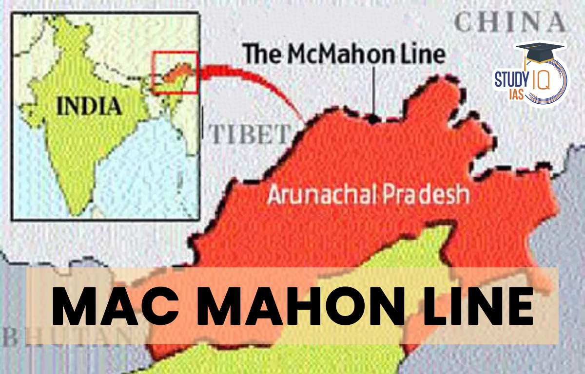
What is the McMahon Line?
- The McMahon Line serves as the de facto boundary between China and India in the Eastern Sector.
- It specifically represents the boundary between Arunachal Pradesh and Tibet, from Bhutan in the west to Myanmar in the east.
- China has historically disputed the boundary and claims the state of Arunachal Pradesh as part of the Tibetan Autonomous Region (TAR).

Under what Circumstances was it Drawn?
- The McMahon Line was drawn during the Simla Convention of 1914, officially described as the Convention Between Great Britain, China, and Tibet.
- The government of the Republic of China represented China at the convention. This government was in power on the mainland from 1912 to 1949.
- In 1949, the leaders of this government were forced to flee to Taiwan during a civil war, which led to the establishment of the communist government in Beijing and the formation of the People’s Republic of China.
- Before the signing of the convention, the border in the eastern Himalayan region (currently India’s Northeast and northern Myanmar) was undefined. The McMahon Line was drawn to mark the boundaries of Tibet and British India’s respective spheres of influence in this region.
- After the first Anglo-Burmese War (1824-26), the British gained almost complete control over the Assam Valley.
- From there, the British expanded their influence outwards in the predominantly tribal lands across the Northeast. For a long time, these tribal lands acted as a buffer between British India and Tibet.
- As the 20th century began, China’s control over Tibet had weakened, and the British were concerned about Tibet coming under Russian influence. To prevent this, the British led an expedition into Tibet and signed the Convention of Lhasa in 1904.
- At the same time, China was worried about Britain’s growing influence in the region. During the final years of the Qing dynasty, China invaded and took control of the southeastern Kham region. This invasion also pushed into the tribal regions north of the Assam Valley. British officials responded by calling for an extension of British jurisdiction into the tribal territory.
Simla Convention of 1913-14
- The convention attempted to settle the question of Tibet’s sovereignty and avoid further territorial disputes in the region.
- The Tibetan government in Lhasa was represented by Paljor Dorje Shatra, and Britain by Sir Arthur Henry McMahon, foreign secretary of British India at Delhi. The Chinese representative was Ivan Chen.
- The treaty divided the Buddhist region into “Outer Tibet” and “Inner Tibet”:
-
- Outer Tibet would “remain in the hands of the Tibetan Government at Lhasa under Chinese suzerainty”, though China was not allowed to interfere in its affairs.
- Inner Tibet would be under the direct jurisdiction of the Republic of China.
- The convention also determined the border between China proper and Tibet as well as Tibet and British India that would later be known as the McMahon Line.
- China’s Response:
-
- While a draft convention was agreed upon by all three countries on April 27, 1914, China immediately rejected it.
- The final convention was only signed by McMahon on behalf of Britain and Shatra on behalf of Lhasa.
- Ivan Chen did not consent to the convention, arguing that Tibet had no independent authority to enter into international agreements.
How was the border between British India and China decided?
- The 890-km border from Bhutan to the Isu Razi Pass on the Burma border was drawn along the crest of the Himalayas.
- The “highest watershed principle” was used to determine the border, which followed the highest ridge between two river plains
- Tawang, which would have been part of Tibet under this principle, was included in British India due to its proximity to the Assam Valley (this was contested by Tibet for years).
- The border remained porous and Lhasa still held some influence in the region.
- The War of 1962 demonstrated the strategic importance of Tawang, as capturing it would give an invading army easy access to the valley in the south.
- McMahon’s decision to include Tawang under British jurisdiction was affirmed by the events of the War of 1962.
The Highest Watershed Principle:
- It is a method of determining the boundary line between two countries that have a mountainous terrain.
- This principle involves drawing the border along the highest ridge or crest that separates the watersheds of two adjacent river systems, with the idea being that this would be the most logical way of drawing borders in mountainous regions.
- This principle aims to follow the natural boundary provided by the mountains, and to avoid disputes over the use and control of water resources that often arise when borders are drawn along river valleys or basins.
Current Status of Mc Mahon Line
- The status of the McMahon line has been disputed since its establishment in 1914.
- China has contested its legitimacy and claimed parts of the territory it demarcates.
- After the communist revolution in China in 1949, the new government repudiated all international agreements and treaties, including the McMahon line.
- China demanded a renegotiation of all its borders, including the McMahon line.
 EPFO VISHWAS 2026: One-Time Dispute Reso...
 MP ADPO Recruitment 2026 Notification Ou...
 FIFA World Cup Winners List From 1930-20...